
Older properties are likely to have changed ownership several times, they might have been altered, extended or rebuilt and may also have changed their use. Building up a picture of the history of a house through time usually involves piecing together information from a variety of record types held in different places, including archive material and online resources. Some of these sources may provide evidence for the building, some for owners and/or occupiers, and some for both.
Our collections contain a variety of records that can provide information about the history of a building. Which of these will be relevant depends upon the location and age of the building, and whether it has had a previous use other than being a home.
The question ‘how old is my house?’ may not be easy to answer if there is neither a surviving written record of who built a house and when, nor any plans or drawings. It is more likely that you will identify an approximate date range, especially for older properties.
The physical structure of the property and its visual appearance can also provide clues to its date:
- Look at the building type and style, materials used and architectural features.
- Consider if there may have been different phases of construction, alterations and extensions.


A Survey with Maps of the Estate belonging to William Serjeantson Esq. lying within the several townships of Hanlith, Kirby in Malhamdale, &c. by George Lang of Leyland, 1776 – showing pages recording lands in Bordley & detail from Plan VI of Bordley Hall Farm [Z.1443]
Key sources for researching building history at the Archives include:
Historic maps and plans
Including tithe maps/apportionments, enclosure maps/awards, estate plans and historic Ordnance Survey maps. Find out more on our introduction to historic maps and plans page.
Historic property deeds
Including the North Riding Registry of Deeds, indentures, conveyances, abstracts of title, manor court books and leases. Find out more on our introduction to historic property deeds page.
Drawings and photographs
Provide a visual record of the history of an area and its buildings; in them we can see what houses looked like. In conjunction with historic maps, aerial photographs and other evidence, they are an excellent resource for tracing how a place may have changed over time.
- Architectural plans and drawings
- Local authority plans and building control records
- Historic photographs and postcards
- Aerial photographs
Documentary evidence
- Estate surveys and rentals
- Unique manuscripts
- Sales catalogues and particulars
- Wills and probate
- Inventories
- Newspapers
All of these, as well as local history publications, articles, and reports on the results of previous research can all contain information about specific property and buildings. We hold a small collection of books on local history, including several place-specific publications. Many more will be found in the local studies reference sections of local North Yorkshire libraries via the online North Yorkshire library catalogue. A list of useful books can be found on our further reading page.
Architectural plans and drawings
Our collections include a variety of architectural plans and drawings, including floor plans, sections and elevations. These cover not only houses, but also churches and other building types. Many, but not all, of these drawings are listed in our Archives Collection Guide no. 10: List of Architectural Plans. They are mainly to be found in our estate and family archive collections, our local authority and building control records and our parish record collections. They include work by many local architects, as well as several of national renown, such as John Carr and Philip Speakman Webb. Some further examples can be seen in our blog on Malton: Architects’ Drawings.


Blueprint of plans, elevations & sections of villa residence at 28 Westbourne Park, Falsgrave, Scarborough by John Hall & Frank A. Tugwell, Architects, 30 May 1888 with accompanying letter from Hall & Tugwell dated 31 May 1888 to the Plans Sub-Committee at Scarborough Town Hall [DC/SCB 3204]
Did you know? The blueprint process, also known as cyanotype, was introduced in 1842 and used into the 20th century. It enabled multiple copies of technical drawings to be reproduced quickly and accurately for the first time. Before this, copies had to be hand drawn.
The original architectural drawing would be traced by the architect or draughtsperson onto tracing paper using ink. This tracing paper would be placed on top of light-sensitive paper and exposed to daylight for a few minutes. Ultraviolet light transmitted through the tracing paper converts the coating on the light-sensitive paper to a blue colour. Where the light is blocked by the ink, the paper remains white. The paper is then washed to remove the light-sensitive coating and dried. As a result, the blueprint is a negative copy of the original drawing, with the clear background areas showing as dark blue and the ink-drawn design reproduced as white lines.
Local authority plans and building control records
Legislation from the 1850s onwards enabled local authorities to introduce building byelaws, which required the submission of plans before the construction or alteration of buildings could take place. Within our archive collections, we hold detailed drawings dating from the 1860s for Scarborough and Skipton.


Plans, elevations & cross-sections of cottages proposed to be built at Carleton, Skipton by George Smith, May 1892 with accompanying notice of the intention to erect a new building submitted to the Skipton Union Rural Sanitary District [DC/SKR IV 2 Vol. 1]
The Town and Country Planning Act 1947 introduced the requirement for planning permission to be obtained from the relevant local council before development could take place. Our collections do not include historic planning applications. For these, we suggest that you contact your local planning authority. This will be your local District or Borough Council, or the relevant National Park Authority if you live in the Yorkshire Dales or North York Moors National Park Authority areas.
Historic photographs and postcards
Historic photographs from the 1840s onwards, and picture postcards from the 1890s onwards, provide a unique record of the built environment and surrounding countryside [EF]. They can show what a house or building used to look like, enabling us to determine how it may have changed over the years by comparison with other visual evidence and/or a standing building.
We hold a large number of historic photographs and postcards many, but not all, of which have been digitised. These historic images can be found throughout our collections, from early glass plate negatives and lantern slides of the 19th century, through to more recent acetate negatives, slides and prints.
They include scenes of North Yorkshire’s towns and villages, family and daily life in the rural and urban communities of North Yorkshire in the 19th and 20th centuries. Often, a picture of a house or building may appear incidentally in the background to a family photograph, or in other photographs of a particular settlement or area of the countryside.
Local photographers, such as Bertram Unné from the 1940s-1970s and Louisa Kruckenberg, from the early 20th century are represented within our collections. However, for many of our images, the photographer is unknown. A large number of our historic photographs can be viewed in our online shop.


- Top left: Postcard of Reeth photographed by James Valentine, early 20th century [EF4/1]
- Top right upper: House in Grafton, c. 1920 [KC00110]
- Top right lower: Terraced housing in Anderson’s Terrace, Scarborough, damaged by parachute mine dropped by enemy aircraft on 10 October 1940 during the Second World War [SC044404]
- Bottom: Queen’s Parade, Scarborough, lodging houses built on the North Cliff in the 1840s & 1850s to cater for the town’s family holiday trade [SC026119]
Aerial photographs
Our aerial photographic collections range in date from the mid-1940s to the 1980s and include both vertical and oblique images, although coverage is not complete for the whole of the county.
The majority of oblique aerial photographs (taken from an angle) were formerly held as part of the North Yorkshire Historic Environment Record. They date mainly from the 1960s to 1980s and were taken by a variety of photographers. Amongst this material are oblique aerial prints from other collections, such as the Cambridge University Committee for Aerial Photography and Historic England.
The vertical aerial images were taken from several thousand feet in the air, using cameras fixed beneath specially modified aircraft, and provide a bird’s-eye view of the ground below. Their original use was to survey large areas for mapping purposes. The earliest of these aerial photographs date from the 1940s, taken by the RAF between 1945-1947. Coverage is not complete, they cover areas of North Yorkshire that were formerly in the West Riding, the North York Moors National Park and sections of the north-east coastline. From the 1960s and 1970s, we hold vertical prints produced by Meridian Airmaps Ltd, Hunting Surveys Ltd and the Ordnance Survey, the largest of which are up to a metre square.
Whilst it is not always possible to see the detail of individual buildings, these aerial photographs are useful to show how an area has changed over time, in a similar way to comparing maps of different dates (see our guide to historic map regression page).

Similar extracts from vertical aerial photographs of Pateley Bridge in Nidderdale showing how the area of settlement has grown around the town over a period of 20 years:
- Left: Dated 26 March 1946 [RAF 106G/UK/1298/4099]
- Right: Dated 21 August 1967 [Meridian Airmaps Ltd W Riding 80-67/025]
Estate surveys and rentals
In the past, much of the land and property in North Yorkshire, as elsewhere in the country, was held by a number of landed families. Accordingly, if your house or farm was once part of one of these larger estates, you may find useful records amongst our estate and family archives. Note that estate records relating to North Yorkshire may also be held by other archive services and in private collections.
Estate surveys were undertaken to record the extent and topography of the landholding of particular owners. They provide evidence for both buildings and associated people and further examples may be seen on our page on sources for owners and occupiers. They usually comprised a plan and an accompanying survey, or field book, although often only one survives without the other; sometimes both were combined in a single volume, as in the example below. Fields and buildings shown on a plan were usually numbered, and these numbers were listed in the survey book recording against each the details of the occupier (tenant), field name, land use (such as arable, pasture, meadow, woodland or house and garden), size (measured in acres, roods and perches). Sometimes the rental value is given (in pounds, shillings and pence).
Surveys were often commissioned for probate purposes after someone had died, or when there was a change in ownership, of land agent/manager, or after new lands had been purchased. Such records were used as part of the day to day administration of estate property and survive in many of our estate collections.

Survey book of Sproxton & Grange, open at Map III showing Sproxton village, by Tukes & Ayer, 1820 [ZEW IV 13/1]
Once such estate collection in our custody, is that of Feversham/Duncombe of Duncombe Park, Helmsley [ZEW]. These estate papers contain an extensive series of surveys and field books, mainly of late-18th and early-19th-century date, which appear to cover every part of the Duncombe property in the Helmsley and Kirkbymoorside areas. They provide a detailed history of tenancy, field names, value of property and acreages owned in each township at that time. Moreover, from 1763 onwards, they are backed up by a fine set of estate maps drawn mainly by Tukes and Ayer, who also undertook their own remarkably detailed survey of the townships on the Duncombe Estate between 1820‑1831. This survey takes the form of twelve leather-bound manuscript volumes, such as the example illustrated above. They contain individual plans for every tenant’s holding, and summaries of the acreages occupied in each township by each tenant [ZEW IV 13/1‑12].
Unique manuscripts
Occasionally, you may find unique forms of documentary evidence containing information about houses and other buildings that are specific to a particular location. These may include diaries, journals, notebooks, scrapbooks, correspondence, personal papers and other manuscripts. For example, in the one-off examples of Hird’s Annals of Bedale and the Burnsall Manuscript, illustrated below, individuals have written about their local areas and recorded a variety of information about particular buildings. They include notes about their history and owners/inhabitants, as well as sketches. Robert Hird, for example, writes numerous notes alongside his pages of verse, making mention of many houses and their owners/occupiers, such as:
“Exelby Grange, the residence of Mr John Alen, 1838. The high and low Grange have undergone as great a renovation in improvement as any places that I am acquainted with. It is now the property of the Coroner, William Dinsdale Esq, Aiskew. The high Grange is occupied by Thomas Horsman, and now is the property of the Dutchess of Cleveland: which she has improved.
The stones which the cross was composed of, is said to have been used in the buildings at Bromaking Grange, about the year 1778, by Mr John Mumforth, when building that situation. He died in the year 1801. (An old sexton’s widow has one shilling annually for clearing the grass from his gravestone) he left his property to Mr John Bell’s family.”
Further details about both these charming 19th-century sources can be found in our online blogs: Hird’s Annals of Bedale and the Burnsall Manuscript.


Pages from Hird’s Annals of Bedale by Robert Hird, shoemaker, showing extracts of the quatrain verse & additional notes giving information about houses in the town & surrounding area, with hand-drawn plan of Bedale Mill, Emgate end & Aiskew Bank, Bedale, c.1808-1841 [ZBA 27/1/18-19]

Pages from the Burnsall Manuscript aka ‘Some Account of the Parishes of Burnsall and Linton in the Deanery of Craven compiled from various sources’ by the Revd William Bury, 1839-1875 [Z.1570] showing:
- Left: House at Linton, with notes on a fire in Sept 1842
- Right: Scale House, near Rylstone, where Revd Bury lodged June-Aug 1839 (now Listed Grade II & of interest for its historic gardens), with notes about the changing ownership of the property.
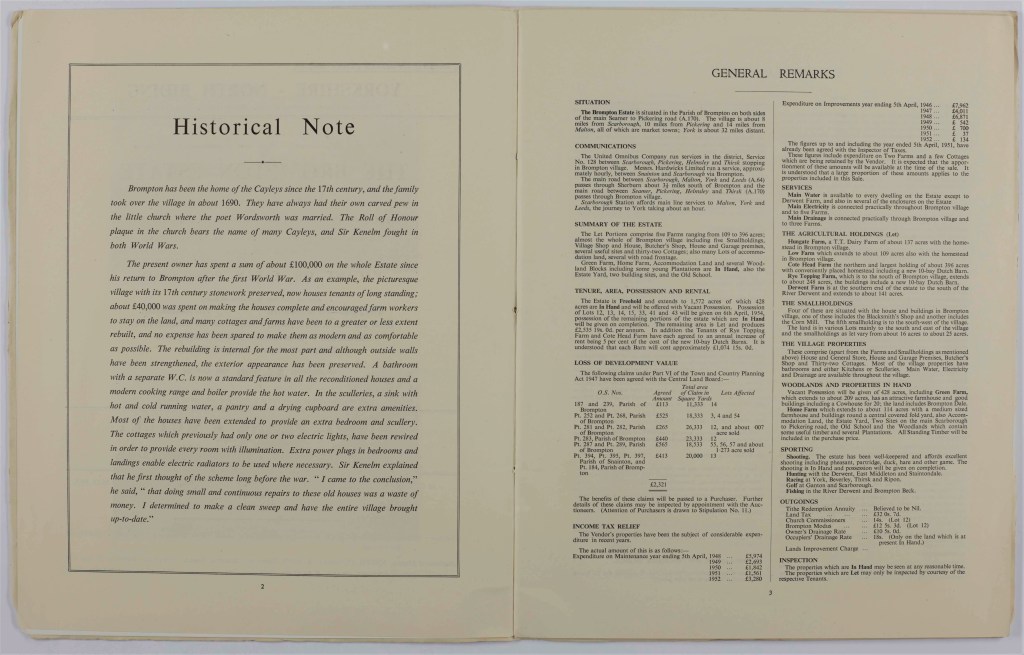
Sale catalogues and particulars

Our collections include a number of sales catalogues and particulars, the majority of which date from the early 19th century onwards. A list of these is available in our search room [K].
Like today’s modern house sale particulars, they include written descriptions, often with photographs and plans. For larger estates, these catalogues provide details of farms and cottages that were part of the wider holding.


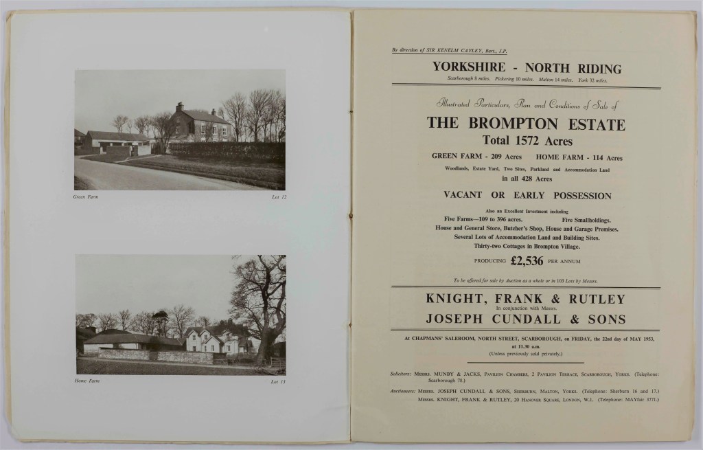


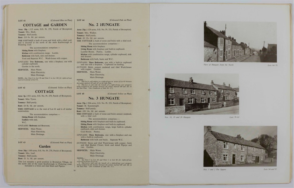
Pages from the sale catalogue of the Brompton Estate, produced by Knight, Frank & Rutley with Messrs Joseph Cundall & Sons, 22 May 1953 [K] containing details & photographs of several cottages & farmhouses amongst the 102 lots
The historical note on page 2 of the above sale catalogue records that the village of Brompton was owned by the Cayley family from the late-17th century. On his return from the First World War, Sir Kenelm Cayley spent a large sum on upgrading and improving properties in the village to make them as modern and comfortable as possible. For each house, this included electrical re-wiring, a bathroom with a separate W.C., a modern cooking range with boiler providing hot water, and a sink with running hot and cold water in the scullery. Sir Kenelm is quoted as saying “I came to the conclusion that doing small and continuous repairs to these old houses was a waste of money. I determined to make a clean sweep and have the entire village brought up-to-date”.
Wills and probate records
Wills are legal documents that record the rights of others over a person’s property. They may contain names and details of the contents of a house, as well as descriptions of the size of the property. Although our collections do not generally hold records of wills and probate, some wills were registered with property in the North Riding Registry of Deeds. Copies of some wills, along with settlements and mortgages, may also be found amongst our estate archive collections.
Before 1858, the Church was responsible for probate (the process of proving that a will is valid) and wills for Yorkshire may be held either at the Borthwick Institute for Archives, York (see their webpage Are you looking for a will?) or the Leeds office of the West Yorkshire Archives Service (see their Collections Guide 4. on Wills).
After 1858, probate became a civil matter. An online search can be made for the will or probate of any person in the UK who died after 1858 using the Government’s ‘Find a Will’ website.
For further information on wills, see the publications noted on our further reading page (Camp, 1963 and Gibson, 1974).
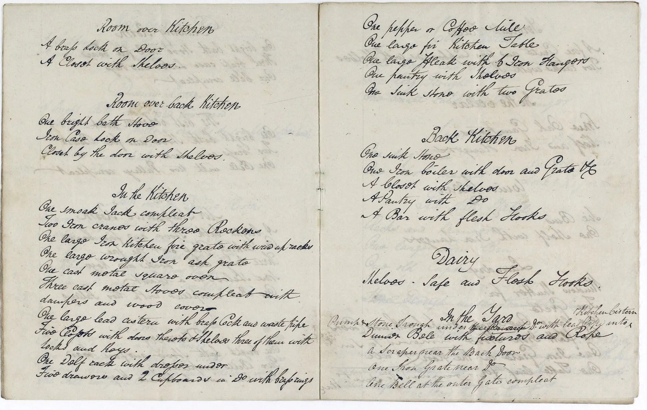
Inventories
Before 1782, every executor or administrator was required to provide an inventory (complete list) of a deceased person’s goods. These lists may not always survive, be some may be found amongst our estate collections. They usually contain a room by room description of the contents of the property, including furniture, linens, tableware and kitchenware, and even livestock.

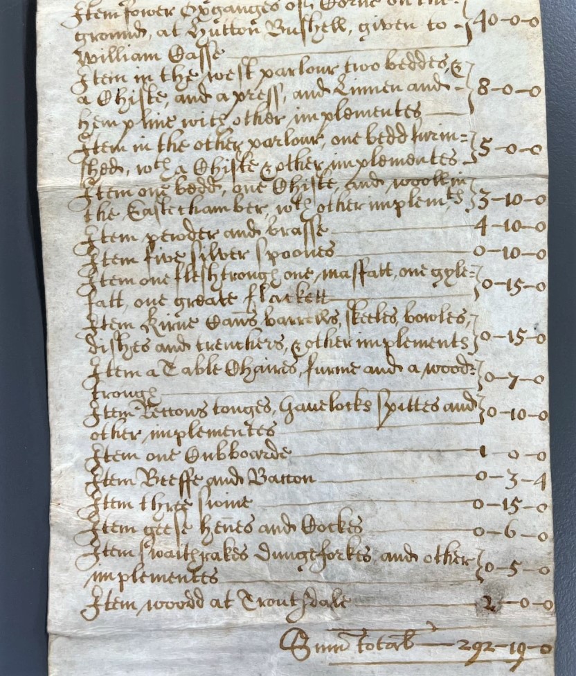
Inventory of Eustace Casse of Sawdon, yeoman, deceased, 1662 with detail of section relating to house contents [Z.54/8]
Amongst details of the land and livestock of Eustace Casse, this inventory records the contents of his house, and their value:
“… Item in the west parlour two beddes, and a Chiste, and a press, and Linnen and hempline with other implements, £8 0s 0d
Item in the other parlour, one bedd furinshed, with a Chiste and other implements, £5 0s 0d
Item one bedd, one Chiste, and wooll in the Easte chamber, with other implements, £3 10s 0d
Item pewder and brasse, £4 10s 0d
Item five silver spoones, £0 10s 0d
Item one fleshtrough one masfatt, one gylefatt, one greate flackett, £0 15s 0d
Item kirne cans’ barrells, skeeles, bowles, dishes and trenchers, and other implements, £0 15s 0d
Item a Table Chaires, furme and a wood’ trough, £0 7s 0d
Item kettons tonges, Gauelocks spittes and other implements, £1 10s 0d
Item one Cubboarde, £1 0s 0d …”
Newspapers
Local newspapers may contain details of properties being advertised for sale or rent, including notices of auctions. More recently, this might include advertisements by estate agents or property developers. There may also be notices of planning applications submitted to District and Borough Councils.
The majority of the old local newspapers we hold can be viewed on microfilm; you will find these listed in the Archives Collection Guide no.1 under the reference ‘N’ (pp. 34-36). There is no detailed index to the content of these newspapers, nor can they be searched digitally.
You will also find local newspaper collections on microfilm in some North Yorkshire libraries, a list of those available at each library can be found on the Libraries – local collections webpage. Some online, searchable historical newspaper resources can be accessed by members of the North Yorkshire library service through Gale Primary Sources: British Library Newspapers of the 18th and 19th century, and the British Newspaper Archive containing newspapers from 1603 to the present day. See the North Yorkshire Libraries online information resources webpage for further details.
