
A variety of records, both archival material and online resources, can help you to discover previous owners and inhabitants of a property. Homes are likely to have changed ownership and/or occupancy several times over the years. We recommend you start with the most recent information you know and work backwards in time. Be aware that an inhabitant of a house is not necessarily the owner, and that an owner may not be the occupier as they may own more than one property.


- Left: Plan of East Witton by William Senior, with names recorded alongside individual houses, 1627 [ZJX 10/1/2]
- Right: Indenture between Hugh Cholmeley of Whitby & Robert Trewhitt of Robin Hood’s Bay regarding the conversion of 2 cottages in Robin Hood’s Bay into 3 dwellings, 1638 [ZCG(W) 1638 no.31]
Key sources for researching previous owners/occupiers at the Archives include:
Historic maps and plans
For further information, see our pages on historic maps.
Historic property deeds
For further information, see our pages on property deeds.
Online databases
We provide free access in our search room via the Ancestry and FindMyPast websites to:
- The 1939 Register
- England census records 1841-1921
Published material
- North Riding & North Yorkshire electoral registers 1832 to 2000
- Trade directories
Taxation, administration and other records
- Estate surveys
- Railway plans and reference books
- Richmond burgage books
- Rate books
- Inland Revenue land valuation records 1910
- Land tax records c.1781-1832
- Window tax
- Hearth tax
- Parish records
1939 Register
The National Archives research guide on the 1939 Register gives an overview of this resource, which provides a record of the civilian population of England and Wales on 29 September 1939. The information recorded for each individual includes their name and address, as well as date of birth and occupation. Some of the online Register entries are redacted (blanked out lines), indicating that the record is closed because the individual may still be alive.
Census records
The National Archives research guide on census records provides details of the background to, and content of, these records that were made every ten years from 1801 (with the exception of 1941) to provide information about the population. The 1841 census was the first to list names of individuals, however, less information was collected in 1841 than in later census years. Before that, between 1801 and 1831, the census was statistical only, the returns did not include details of individuals and their names. However, such information may have been written down by those compiling the statistics, which included the clergy and Overseers of the Poor. In rare instances, such notes may survive amongst ecclesiastical parish records, for example the 1801 census notes for Newby Wiske in amongst the Kirkby Wiske parish records in our collections. Whilst these provide a list of inhabitants (see image below), it is not clear which specific houses they lived in.


- Left: Census return notes for Newby Wiske, 1801 [PR/KRN 5]
- Right: Page from census return for Newby Wiske, 1901 [GBC_1901_4546-4549_0501 from FindMyPast website]
The following information on addresses in the census is taken from The National Archives research guide:
“Exact addresses were not required in 1841, only ‘place’. From 1851 an exact address was required, including the house name or number, if any. However, in rural areas the only information given still might be the name of the village or parish. Numbers in the left-hand column are schedule numbers, and should not be mistaken for house numbers.
A note was made of buildings that were uninhabited, or under construction, in every census year. In 1891 and 1901 the number of rooms in a dwelling was listed, if fewer than five. In 1911 and 1921 the number of rooms is shown on all household schedules, and other information is in the Enumerators’ Summary Books, described in section 5, above, for 1911 only.
From 1851 to 1901 a census entry for a new household is indicated by a new schedule number. In all census years except 1851, 1911 and 1921 the last entry in a building is indicated by a double oblique line //, and where there is more than one household within a building, they are separated by a single oblique line /. In 1851 a line is ruled across the page at the end of a building, or half-way across the page between households within a building.“
Viewing 1939 Register and census records (1841-1921)
These records are not part of our collections, but can be viewed online via commercial, subscription websites, including Ancestry and FindmyPast. 1921 England census records are currently only available via FindMyPast. We have a People’s Network computer in our search room that provides free access to these websites, which can be booked by appointment. North Yorkshire libraries also provide limited free access at most of their branches.
Electoral registers 1832 to 2000
Our collections include North Riding electoral registers from 1832-1973 and North Yorkshire electoral registers from 1974-2000 [QDE(R)]. From 1885 onwards, these registers were compiled on a constituency basis.
Since 1974, for the modern county of North Yorkshire, registers have been compiled by the District and Borough Councils, copies of which are deposited in the Archives up to the early 2000s. The registers may be consulted by prior appointment in our search room. Some registers are accessible on self-service microfilm, details of these and the related microfilm numbers can be found listed under the reference QDE(R) in Archives Collection Guide no.1 (pp 71-74).
North Riding electoral registers 1832-1971 are available to search online via Ancestry, provided in association with North Yorkshire County Archives via this link.
West Riding electoral registers 1840-1962 are available to search online via Ancestry, provided in association with the West Yorkshire Archive Service via this link.
Electoral registers were first introduced in 1832 with the Great Reform Act. They were compiled annually (except for the war years 1916-1917 and 1940-1944) to record members of the population who were entitled and registered to vote and include the reasons for their eligibility. Following the First and Second World Wars, registers of absent voters were produced to record those away from home on military service. Before 1918, the right to vote was closely linked to ownership or occupation of a property. Registers include names and addresses and the nature of qualification/description of property, though they may vary in their detail and format. The general arrangement for each polling district is in address order, i.e. with streets listed in alphabetical order and properties within them listed in sequence (which is not always ordered by house number). In rural areas, voters are usually listed alphabetically by surname, followed by their first name. Detailed street names and house names/numbers are not always given, especially in earlier registers.
The 1832 Act extended the vote to an estimated one in seven men aged 21 years and over, who owned or occupied lands and tenements worth between £2 and £5 per annum, thus including tenants for the first time. Holders of property worth more than £10 were also given the right to vote.
The second Reform Act 1867 increased the number of men who could vote in elections to all owners of real estate worth £5 or more, as well as those who occupied land and paid rent of £50 or more per year and owners and tenants of lands with a rateable value of £12 or more who were paying taxes.
The third Reform Act 1884 further extended the vote to freeholders of inherited land worth 40s, freeholders of any land worth £5 and certain leaseholders, occupiers and lodgers. The majority of male householders over 21 (estimated at over 60%) were now entitled to vote, but they must have resided in one place for twelve months.
Some women were entitled to vote for the first time in 1918 following the Representation of the People Act. They had to be aged over 30 and be householders, or wives of householders. All men over 21 were entitled to vote; they must have resided in one place for six months. In 1928, the vote was given to all men and women over the age of 21. This age limit was reduced to 18 in 1969.
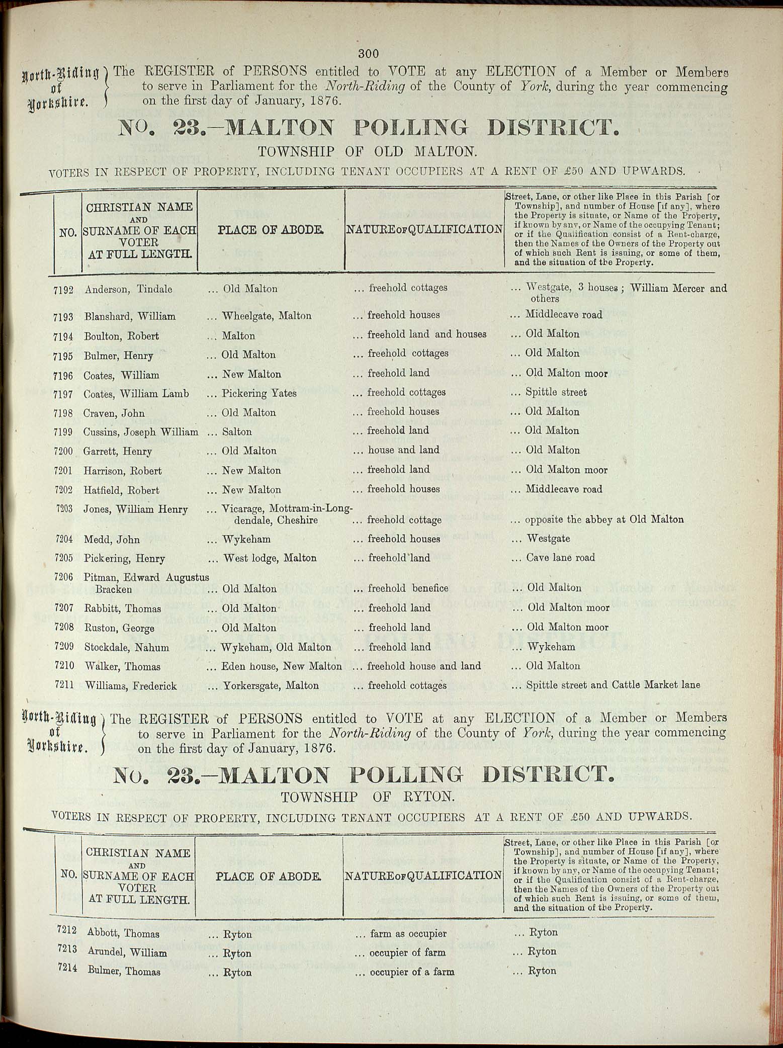

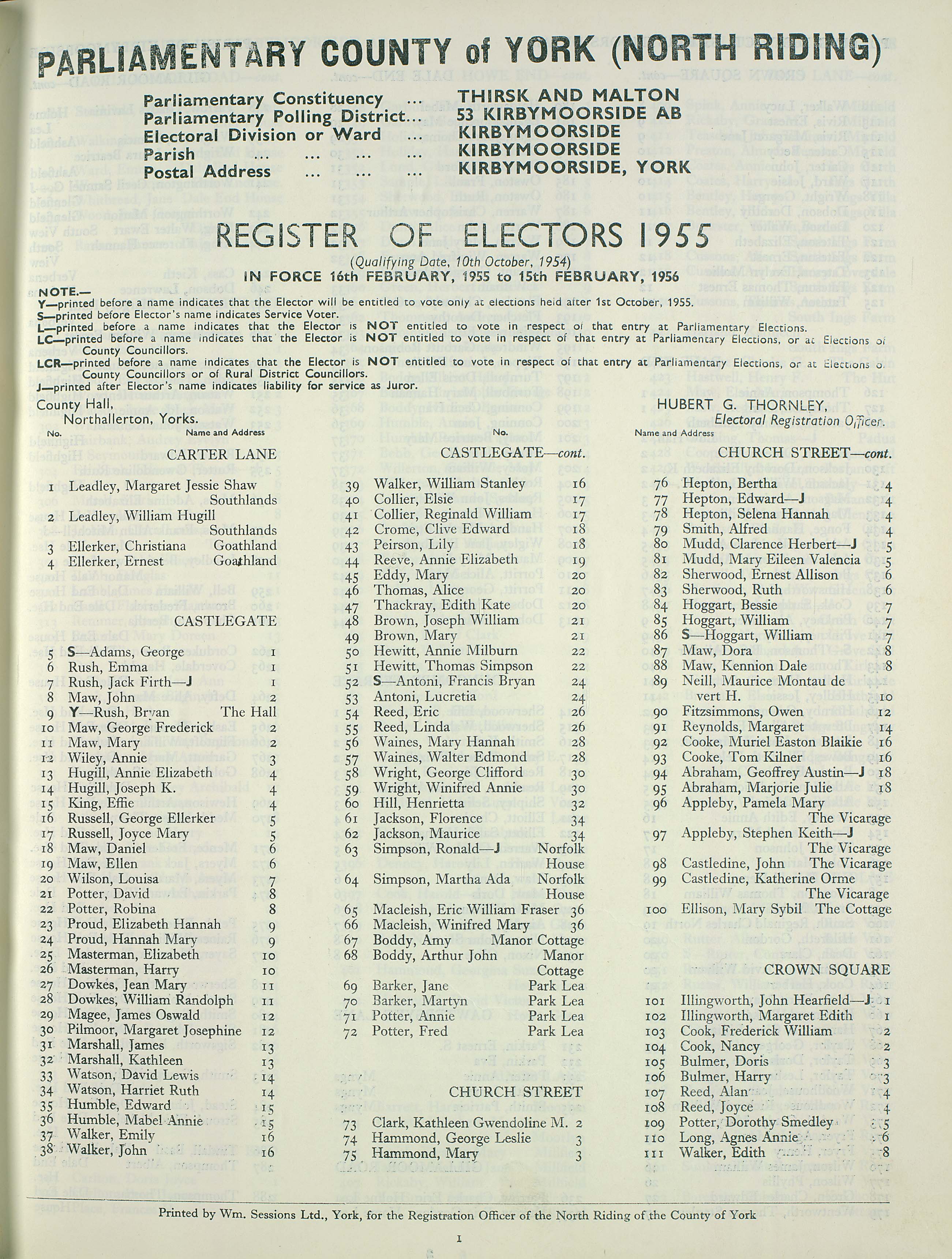
Left to right: Pages from North Riding electoral registers for the townships of Old Malton 1876; Scarborough 1892 & Kirkbymoorside 1955 [QDE(R)]
In the examples above, you can see the differences in the format and content of the register entries. In 1876 and 1892, those eligible to vote are listed alphabetically by surname, whereas by 1955, entries are arranged alphabetically by street name and then by house number. In 1876, place of abode is usually recorded by place-name, with occasional mentions of house or street names. In Scarborough in 1892, both street names and numbers are given.
Trade directories
Directories were published from the 18th century, providing information about local towns and villages, their inhabitants and local businesses. They may be helpful in tracing the history of houses and commercial premises as they contain lists of the names of residents and traders.
We hold a limited number of 19th and early-20th-century trade directories for the North Riding of Yorkshire; others may be found in North Yorkshire library local studies reference collections, using the online North Yorkshire library catalogue. Entries in the directory usually begin with a short history and description of each town or village, followed by an alphabetical list of names and addresses of private and commercial residents, the latter including shopkeepers and tradespeople. As with electoral registers (see above), there are differences in the format and content of directory entries depending upon the date of publication and whether areas are urban or rural. In smaller townships, such as those illustrated below in 1937, occasional farm, house or street names may be given, but not detailed addresses. In urban areas, especially in later editions, both street names and numbers are recorded.


Further information about historical directories and a searchable online collection of digital directories from the 1760s to the 1910s can be found via the University of Leicester Archives and Special Collections website.
British phone books published between 1880 (the year after the public telephone service was introduced to the UK) and 1984, from the historic phone book collection held by the British Telecom (BT) Archives, are also available online via Ancestry.co.uk.
Estate surveys
Estate surveys are one of the sources of evidence that can provide information about both buildings and people. Undertaken to record the property of particular owners, estate surveys may comprise plans with details of occupiers/tenants either written on the map itself, or recorded in a separate survey, or field book, which may or may not survive with the map. In some instances, several smaller maps of different areas or farms of larger estates were drawn in portable, leather-bound volumes containing details of tenants, the acreages of fields and often their rental values. Further examples of such books can be seen on the overview of sources for buildings webpage.

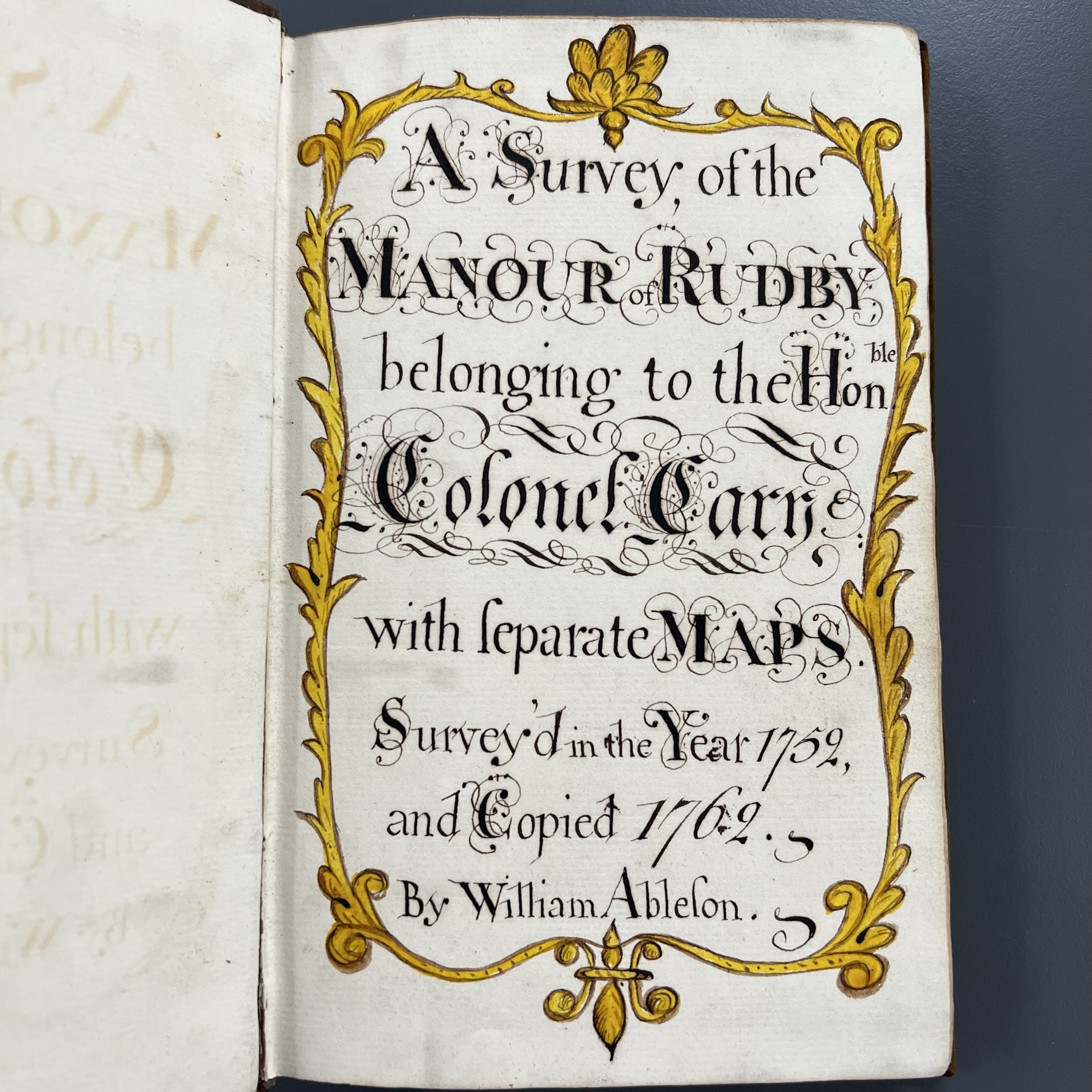

A survey of the manor of Rudby belonging to the Honourable Colonel Cary surveyed in the year 1752 & copied 1762, by William Ableson, 1762 [ZFD]
Many examples of estate surveys are held within our extensive collections of estate and family archives. These collections, which have references beginning with the letter ‘Z’, can be identified within our online catalogue and Archives Collection Guide no.1.


Extracts from ‘Plans & Particulars of the Right Honourable Lord Dundas’s Marsk, Redcar & Upleatham Estates and also of the Freeholds within the Manors’, by Thomas Bradley, 1815 [ZNK V 3/1/30]
Railway plans and reference books
If your home is located close to a railway line, it is possible that information about owners and occupiers may be found using historic railway plans and their associated reference books [QDP(M) & NG/RY]. Details of these holdings may be found in our Archives Collection Guide no.8: List of Plans of Railway Lines & Buildings. The list of railway lines is indexed by place and by line at the back of the volume. This collection can also provide information about railway buildings, such as station master’s houses (see our page on sources for buildings with other uses).
Plans of undertakings that required authorisation by Act of Parliament (e.g. railways, canals, turnpike roads, docks, harbours & piers, gas & water works) were to be deposited and made available for public inspection at the time of the Parliamentary Bill needed to authorise the undertaking. Our collection holds 412 such plans dating from 1792 to 1960. Most of the railway plans are accompanied by a book of reference giving details of the owners and occupiers of the lands crossed by the line. The plans deposited with us relate only to lines wholly or partially in the North Riding. Deposited plans for the former West Riding are held by the West Yorkshire Archive Service, Wakefield and those for the former East Riding at the East Riding Archives in Beverley.
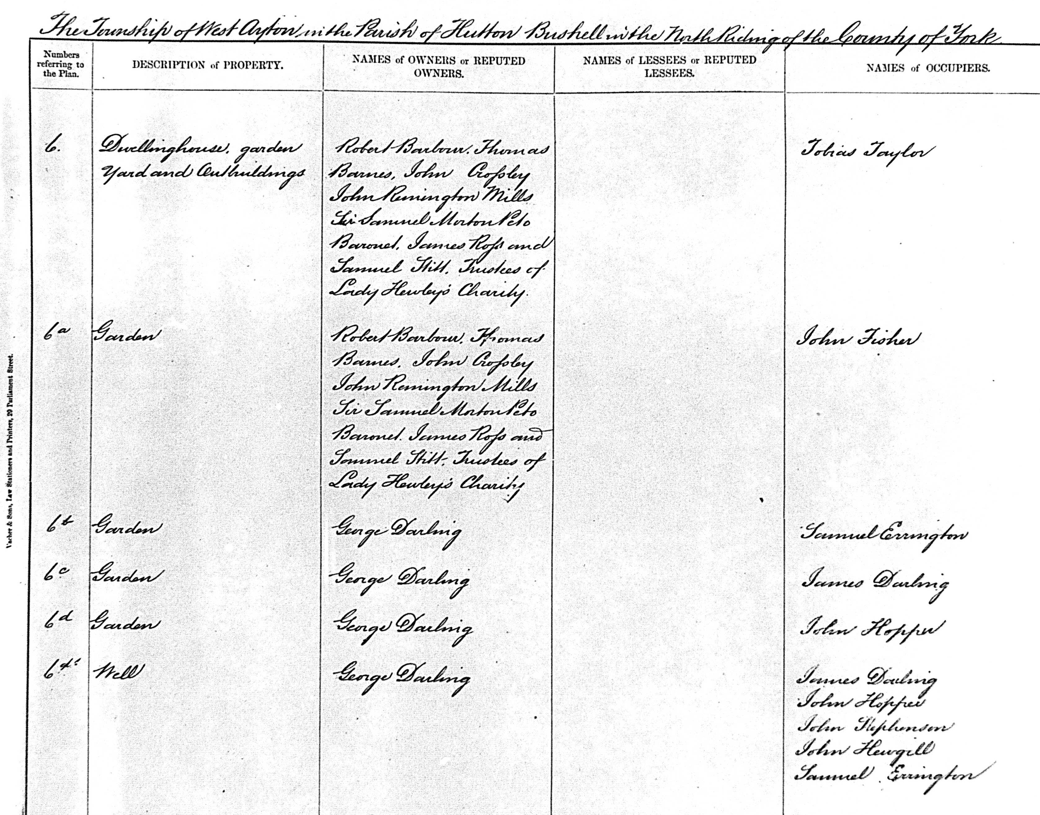


Forge Valley Railway, Page from Book of Reference to the Plans, showing owners & occupiers of numbered property (numbers refer to the plan), 1873 [QDP(M) 190/2]
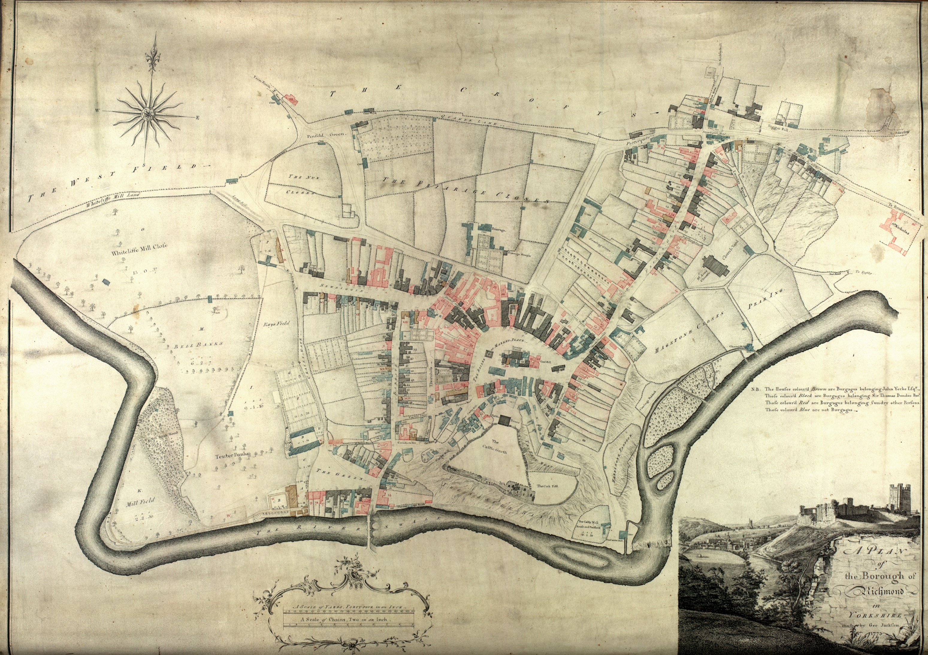
Richmond burgage books
During the 17th and 18th centuries, the right of voting in the parliamentary borough of Richmond was transferred to owners of specific houses, which became known as burgage houses. Further details, including transcriptions of burgage books can be found in NYCRO publication Richmond Burgage Houses: surveys of 1679, 1773 and 1820, ed. Leslie P. Wenham, 1978. This volume supplies information on the location and owners of the burgage houses for 1679, 1773 and 1820.


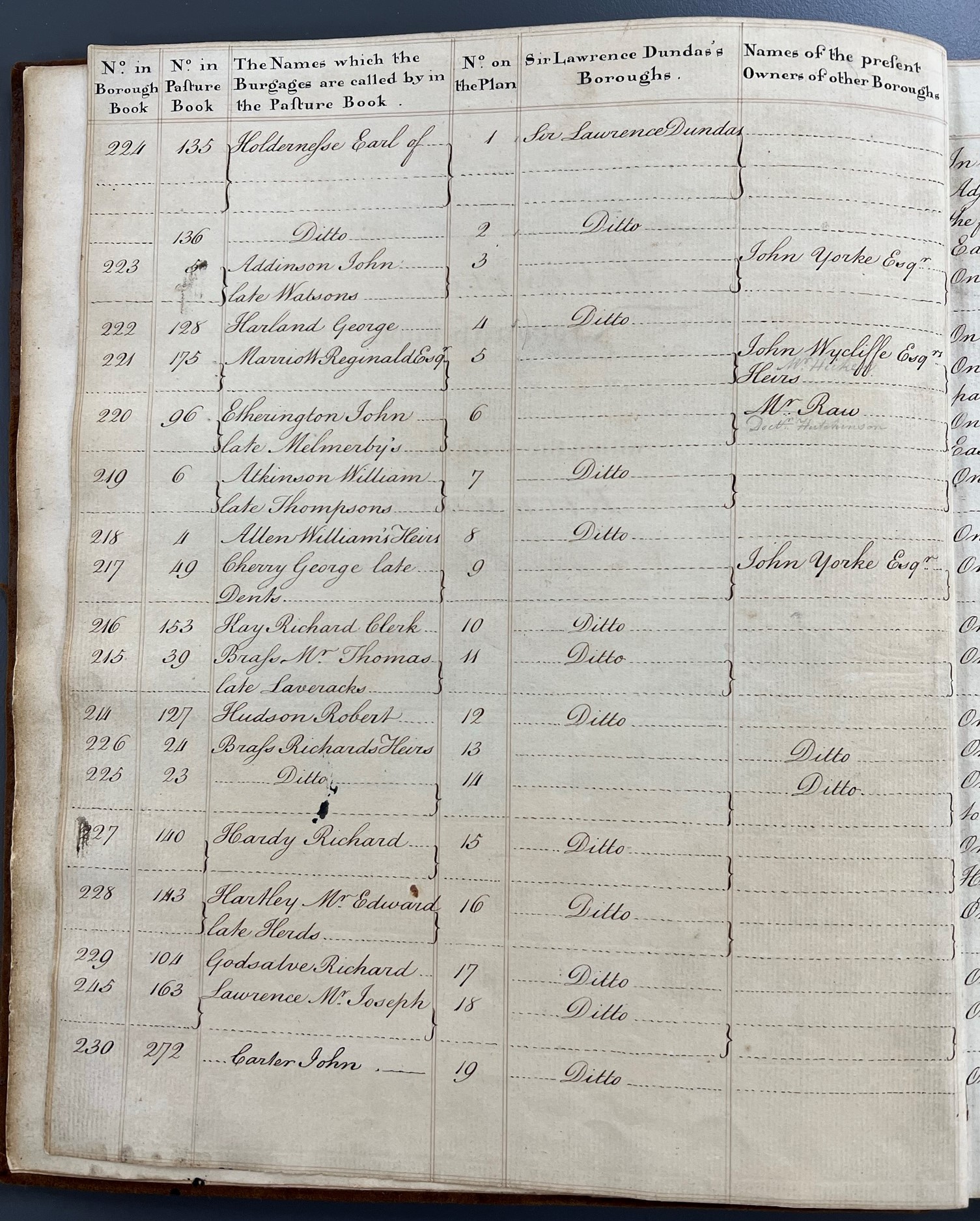

Images of a ‘complete borough book of all the burgage houses within the borough of Richmond’, by George Jackson, 1773 [ZNK V 2/1/2] – the numbers in this book relate to those on the accompanying map (see below)
Rate books
Our parish church record collections may sometimes contain poor rate books. After the Poor Law Amendment Act, 1834 rate collection was transferred to local councils, so rate books can also be found in our parish council and district council collections. Prior to the 1980s, these record the levying and payment of rates in each parish and are usually listed by street and householder, although it can be challenging to establish which specific building an entry is referring to in earlier records for rural areas.

Inland Revenue land valuation records 1911
Under the provisions of the Finance (1909-1910) Act 1910, the Commissioners of the Inland Revenue were instructed to ‘cause a valuation to be made of all land in the United Kingdom’. The valuation books for this survey are deposited at the Archives [NG/V]. They include the names of the owners and occupiers of land, a summary description of the property and its situation, and a reference to the series of valuation maps. Note that it may not always be possible to identify a specific building in these books without the related valuation maps held by The National Archives as detailed addresses are not recorded.
Appendix III of Archives Collection Guide no.1, listed alphabetically by place-name, provides reference numbers for the self-service microfilms on which the valuation books may be viewed by appointment in our search room.

The associated valuation maps and the field books are held by The National Archives at Kew. Their online guide to the Valuation Office Survey 1910-1915 provides further details.
The field books may contain a description of a particular property as they were filled in with considerably more information, and frequently included plans (Beech & Mitchell 2004).
Land tax assessments
A land tax was imposed from 1692 to 1832 and was made perpetual in 1797. From 1780, duplicate returns had to be lodged with the Clerk of the Peace to be used to establish voters’ qualifications. Some early assessments survive in our collections, and the returns are fairly complete for all wapentakes from 1781 to 1832 [QDE(L)]. They record assessments for each property, usually naming the landowner and occupier.
Land tax assessments 1692-1832 may be consulted on microfilm in our search room. You can find the reference numbers of the relevant microfilms in Appendix II of Archives Collection Guide no.1 (p. 221), listed by wapentake and date.

Window tax
The Window Tax was a tax on windows or similar openings, levied from 1696 until it was abolished in 1851. We have no comprehensive collection of Window Tax records. Returns were not enrolled among the records of the North Riding Quarter Sessions, although occasional returns may rarely be found in estate archive collections. These records typically contain names of occupiers and tax payable, and later, numbers of windows; property names and addresses are not generally noted in earlier records.
Hearth tax
The Hearth Tax was levied on households between 1662 and 1689. Original Hearth Tax records are held by The National Archives about which there is a podcast on their website. Further information about the Hearth Tax may be found on the Hearth Tax Research project’s Hearth Tax Digital website.
We hold transcriptions of the Hearth Tax lists for the North, East and West Ridings dating to 1672-3. These were published by the Ripon Historical Society and Ripon, Harrogate and District Family History Group in the 1990s and are available to consult in our search room. These include names of occupiers and numbers of hearths; property names and addresses are not noted.
Parish records
Should you wish to find out more about early residents or owners of your property, you may find information about them and their families in the parish record collections held by ourselves and neighbouring archives. These include registers of baptisms, marriages and burials beginning in the early-16th century, from 1538. Details of the date range of the registers for each parish and their whereabouts can be found in Archives Collection Guide no.5 Location of Parish Registers in the County of North Yorkshire.
Parish registers may be consulted in our search room by appointment; they are available to view on self-service microfilm only, in order to protect the unique original documents from wear and tear. A large number of parish register transcripts can also be accessed in the search room; where these exist, they can be identified by a lower case letter ‘t’ against the parish name in the lists of registers at the Archives in Collection Guide no. 2. Many of our parish record collections are accessible via both the subscription websites FindMyPast and Ancestry. We have a People’s Network computer in our search room that provides free access to these websites, which can be booked by appointment. North Yorkshire libraries also provide limited free access at most of their branches.
