
Comparing a sequence of maps and plans of different dates for the same area, looking for changes and similarities working backwards through time is called map regression. This may help you to:
- establish dates the property was built between
- identify how the building footprint might have changed over time
- see if the house name or address has changed
- discover former owners and occupiers
- find out an earlier use of the site
- place the house in its wider context
- track changes in the surrounding area
Map regression case study for the Old Vicarage, Alne, near Easingwold, North Yorkshire:
- Step 1a: Identify your research area/property on a modern Ordnance Survey map using the NYC maps webpage ‘general maps’ function
- Step 1b: Identify your research area/property on an older Ordnance Survey map using the NYC maps webpage ‘historic maps’ function
- Step 2: Identify fixed points of reference
- Step 3: Identify which historic maps are held at the Archives
- Step 4: Compare the various maps
- Step 5: Verify your evidence
This five-step case study provides a practical, visual guide to carrying out a map regression exercise for house history, using the resources described on our historic maps and plans webpage. The examples below show a sequence of online Ordnance Survey maps and historic maps from our collections for the village of Alne. Using these, it is possible to regress (work backwards) in time through a period of over 200 years to the year 1771. (Not all areas of the county will necessarily be represented in our historic map collections so fully, but online Ordnance Survey maps will give you a good starting point and you may find older maps in other archive collections held elsewhere if we do not have them).
Step 1a: Identify your research area/property on a modern Ordnance Survey map using the North Yorkshire Council maps webpage ‘general maps’ function
You will see different scales and types of Ordnance Survey map showing at different zoom levels using the + and – buttons.
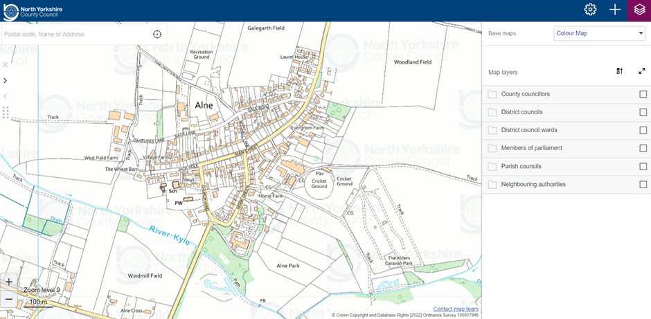
- Left: Screenshot of NYC general map webpage showing map view of raster image of 1:50,000 scale Ordnance Survey Landranger map at Zoom level 9 with Colour Map selected as the base map – the address search box is at the top left of the screen
- Right: Screenshot of NYC general map webpage showing research area as vector Ordnance Survey data viewed at Zoom level 11 with Colour Map selected as the base map
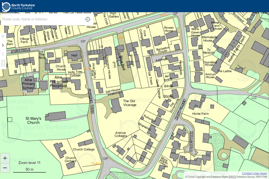
Step 1b: Identify your research area/property on an older Ordnance Survey map using the North Yorkshire Council maps webpage ‘historic maps’ function
You can select different editions of the base map to see how the area changes through time back to the 1850s. Viewing at zoom levels 10 and below will remove the red overlay of the modern mapping.
NB: The closer you zoom in, the more the base map will look grainy (pixelate) as it is a raster image made up of pixels. The red overlay will stay in focus as it is vector data, which is made up of digital lines and points and is infinitely scalable. Due to the relative accuracy of the various map editions, the red overlay will not always correlate exactly with the base map, but it provides a helpful guide to compare present with past.


- Left: Screenshot of NYC historic maps webpage showing map view at Zoom level 9 with 1953-58 selected as the base map
- Right: Screenshot of NYC historic maps webpage showing research area viewed at Zoom level 11 with 1953-58 as the base map, when the red outlines of the modern Landmark Information Group Ltd mapping will appear as an overlay
Step 2: Identify fixed points of reference
Before you move on to looking at earlier maps, find a number of fixed points or features of reference so you will be able to identify and compare your research area between maps more easily. Older maps may look different and be drawn at different scales.
In this example, we have chosen three reference features:
- St Mary’s Church to the west,
- the distinctive inverted (upside-down) triangular shape of the road layout of Monk Green (to the east), Church Wynd (to the west) and Main Street (to the north),
- the course of the River Kyle to the south, which is aligned approximately east to west.
We have also made a note of the direction of the cardinal compass points (north, east, south and west). Not all historic maps are drawn with north to the top, as the Ordnance Survey maps are.
Step 3: Identify which historic maps are held at the Archives
Using our Archives Collection Guide no. 3: List of North Yorkshire & North Riding Maps & Plans and Guide no. 4: List of North Yorkshire & North Riding Enclosure Awards & associated documents and our Ordnance Survey map lists in our search room, we have identified six maps of Alne, and an additional Ordnance Survey map edition available online via the National Library for Scotland maps website:
| Date | Description | Ref | Microfilm/Frame no. |
| 1911 | Ordnance Survey (2nd edition) 25-inch to one mile scale, revised 1909 | Sheet 139.6 | MIC 1897, also via maps.nls.uk website |
| 1893 | Ordnance Survey (1st edition) 25-inch to one mile scale, surveyed 1891 | Sheet 139.6 | Available online via maps.nls.uk website |
| 1856 | Ordnance Survey (1st edition) 6-inch to one mile scale, surveyed 1848-1852 | Sheet 139 | MIC 1830, also via maps.nls.uk website |
| 1843/1844 | Alne Tithe map and apportionment | T | MIC 1771/97-103 |
| 1811 | Alne Enclosure map and award | I (PR/ALN) | MIC 315 |
| 1795 | Plan of open fields and ings, Alne | M5 | MIC 1685 |
| 1771 | Jefferys’ map of Yorkshire, Plate 8 | ZDU | MIC 1919/229-430 |
You may also to wish to check the coverage of our historic aerial photograph collections for your area.


published 1911, Sheet 139.6
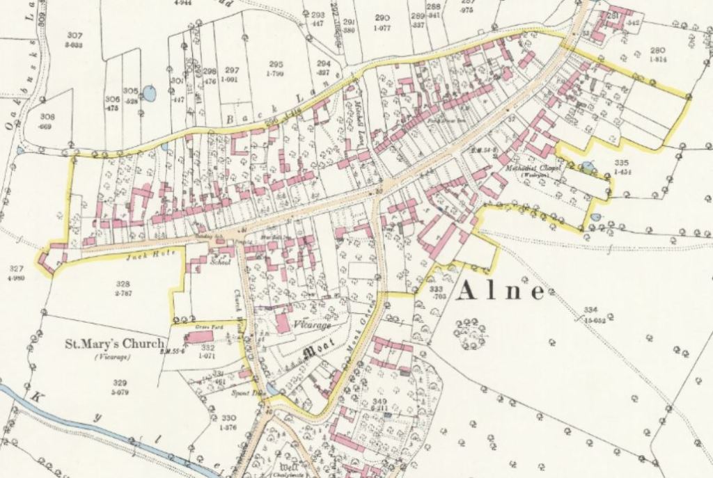
published 1893, Sheet 139.6
(screenshot from maps.nls.uk website
reproduced CC-BY-NC-SA)
TIP: Keep organised notes about the various maps (and any other records) you have consulted and where they are held, their dates, titles and archive references. This is useful if you need to consult the material again at a later date and is essential if you are preparing a report on your findings so you can reference your sources of information. You may find that a spreadsheet helps you to record and organise information in chronological order.
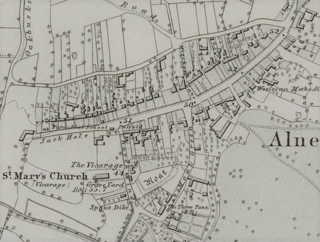
published 1856, Sheet 139

Step 4: Compare the various maps
Starting with the most recent, and working backwards in time, study each map carefully, one by one. Locate the building you are researching and note how it is depicted. Then compare and contrast what you can see between the different maps by looking at them together.
What features can you see, what is not shown? Why might this be the case? Consider the following questions in relation to what you can see:
- What is the scale and orientation of the map?
- What is the date of the map?
- Why was the map produced, and for whom?

Jefferys’ map of Yorkshire, 1771 [ZDU]
| Map and date | What does it show? |
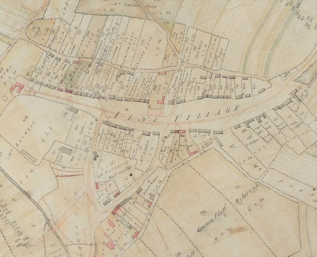
| Current mapping | Building named as ‘The Old Vicarage’, with outbuildings to north, set back from Church Wynd & surrounded by garden |
| 1911 OS map (revised 1909) | Building named as ‘Vicarage’, with outbuildings to north, set back from Church Wynd & surrounded by gardens & orchard, with ditches of former moated site shown to south & east (likely to represent the site of an earlier medieval hall) |
| 1893 OS map (surveyed 1891) | Building named as ‘Vicarage’, with outbuildings to north, set back from Church Wynd & surrounded by gardens & orchard, with ditches of former moated site shown to south & east (on different site to the vicarage shown on the earlier 1856 OS map) |
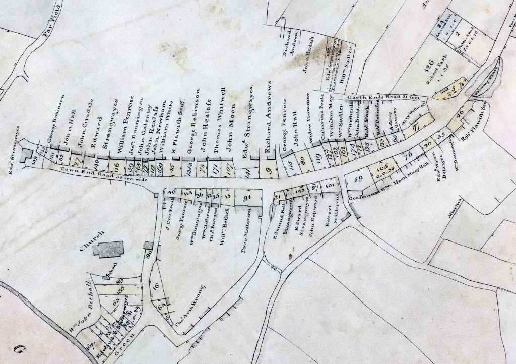
| 1856 OS map (surveyed 1848-1852) | Building named as ‘The Vicarage’ on small plot close to Church Wynd, further west than the building shown on later maps (which does not appear on this map). Outbuildings to north-east & south. Orchard and moat in separate plots to east. |
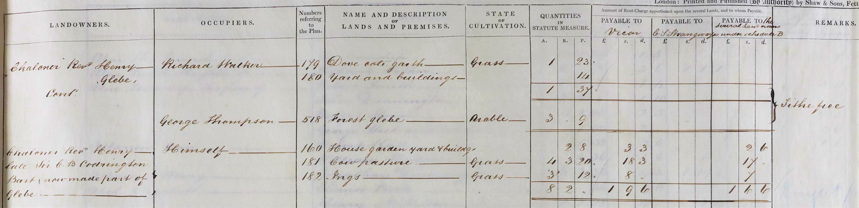
| 1843 Tithe map & 1844 apportionment | Building in same location as 1856 OS map shown numbered 160. Recorded in the apportionment as ‘house, garden, yard and building‘, measuring an area of 2 roods and 8 perches. Landowner noted as ‘Revd. Henry Chaloner, late Sir C.B. Codrinton Bart., now made part of Glebe‘. Occupier is the Revd. Henry Chaloner himself.* * Sir Christopher Bethell Codrington is most likely the person referred to here. Historical information about the parish of Alne in the Victoria County History (see online sources below) refers to Sir C. Bethell-Codrington holding the advowson from 1836 to 1873 (advowson is the right to nominate a candidate to the bishop for appointment as rector or vicar of a church). |
| 1811 enclosure map | Unnamed building shown only in part in the same location as building no. 160 on tithe map. Limited details are mapped for this area of the village, as is the case for other parts of the settlement, most likely as these areas were not related to the main purpose for which the map was drawn (see questions to consider when looking at historic maps). Other properties in the village are numbered & have names of owners written against them; further details are likely to be found within the associated Enclosure Award. |
| 1795 plan | Unnamed building shown in same location as on the 1811 & 1843 maps. Land to the east is labelled as ‘MR BETHELLS’ and named as ‘Hall Garths’, a reference no doubt to the moated site. Numbers, acreages & names are written against individual properties. If there was originally a survey or field book recording additional details to accompany this plan, it does not survive within our collections. |
| 1771 Jefferys’ map | On large, county-wide maps such as this, the mapping is not sufficiently detailed to rely on for accurate depictions of individual buildings, although in this representation of the village, the church is clearly visible and so is the triangular road layout |
Conclusion: What do these maps tell us about the history of The Old Vicarage in Alne and the site it is built on?
To conclude, through a comparison of these various maps and seeing when the building is first shown, we can deduce that the building named as ‘The Old Vicarage’ on the modern OS map was most likely built as a vicarage between 1848/1852 and 1891. It appears to have been built as a replacement for an earlier building that stood a small distance to the west, closer to Church Wynd.
We know this earlier building was in existence as early as 1795 through to 1848/1852, but had disappeared by 1891. It is named as a vicarage in 1848/1852. From the tithe apportionment of 1844, we know that it was owned at that time by Revd. Henry Chaloner and previously by Sir C.B. Codrington.
Looking closely at the depiction of this earlier building on the maps, you can also see slight changes to the shape of the building footprint and surrounding outbuildings, which may indicate extensions and alterations to the property over time.
The mapping of surviving remains of part of the ditched enclosure of a moated site, and the name ‘Hall Garths’, indicate that this area is the site of an earlier medieval hall.
Step 5: Verify your evidence
Once you have collated the findings from your map regression exercise and drawn conclusions about any changes through time, where possible cross refer with other sources. Integrate the mapping data with evidence you’ve gained from other material to check your conclusions and identify/review any questions you have. Look for other records that may help to answer your questions and provide you with further information.
For example, you might want to investigate some of the following questions using a range of other sources held at the Archives, held elsewhere and online:
Can a more precise date for the building of the Old Vicarage be found? and When did it cease to be used as a vicarage house?
- Look in the ecclesiastical parish records of Alne [PR/ALN], held by the Borthwick Institute for Archives, University of York
- Look for historic property deeds in the NRRD
- Check other online archive catalogues to see if records relating to Alne are held in collections elsewhere.
Which vicars might have lived in either of the vicarages? Who has lived there since?
- There is a List of vicars of Alne on the Genuki website, which contains a range of information about the parish
- Look for previous inhabitants in the online 1939 Register and census records (1841-1921)
- Check trade directories and electoral registers for previous occupants
- Extracts from the Imaginary Diary of Mrs Sarah Elizabeth Young, wife of the Revd. Hamilton Young who was vicar of Alne from 1895-1908, compiled from a variety of sources & available as a pdf via the Alne Village website (this document contains an historic photograph of the Vicarage c.1910).
Is there any other evidence for the moated site and the history of the Bethell family?
- The Victoria County History contains historical information about Alne Parish in A History of the County of York North Riding: Volume 2, ed. William Page, 1923, pp. 85-91 via the British History Online website.
- There is an archaeological record for the medieval moated site at Alne [MNY 18416] from the online North Yorkshire Historic Environnment Record accessible via the Heritage Gateway website.
