
A medieval rental of 1434 and Victorian tithe records of 1847 allow us to compare and contrast field names recorded over 400 years apart, plus earlier 13th-century documents show former ownership of land by Byland Abbey
Lying in a valley on the western side of the North York Moors, land at Dale was recorded in 1086 in Domesday Book. The archive of the Mauleverer family, who once owned Dale, contains a collection of related medieval documents; 13th and 14th-century documents show former landholding in Dale by Byland Abbey and subsequent grants by the Colville family. A rental of 1434 (below) lists the holdings of 19 tenants, naming many parcels of land, which differ from the post-enclosure field names recorded in the 1847 tithe apportionment (see below at end).
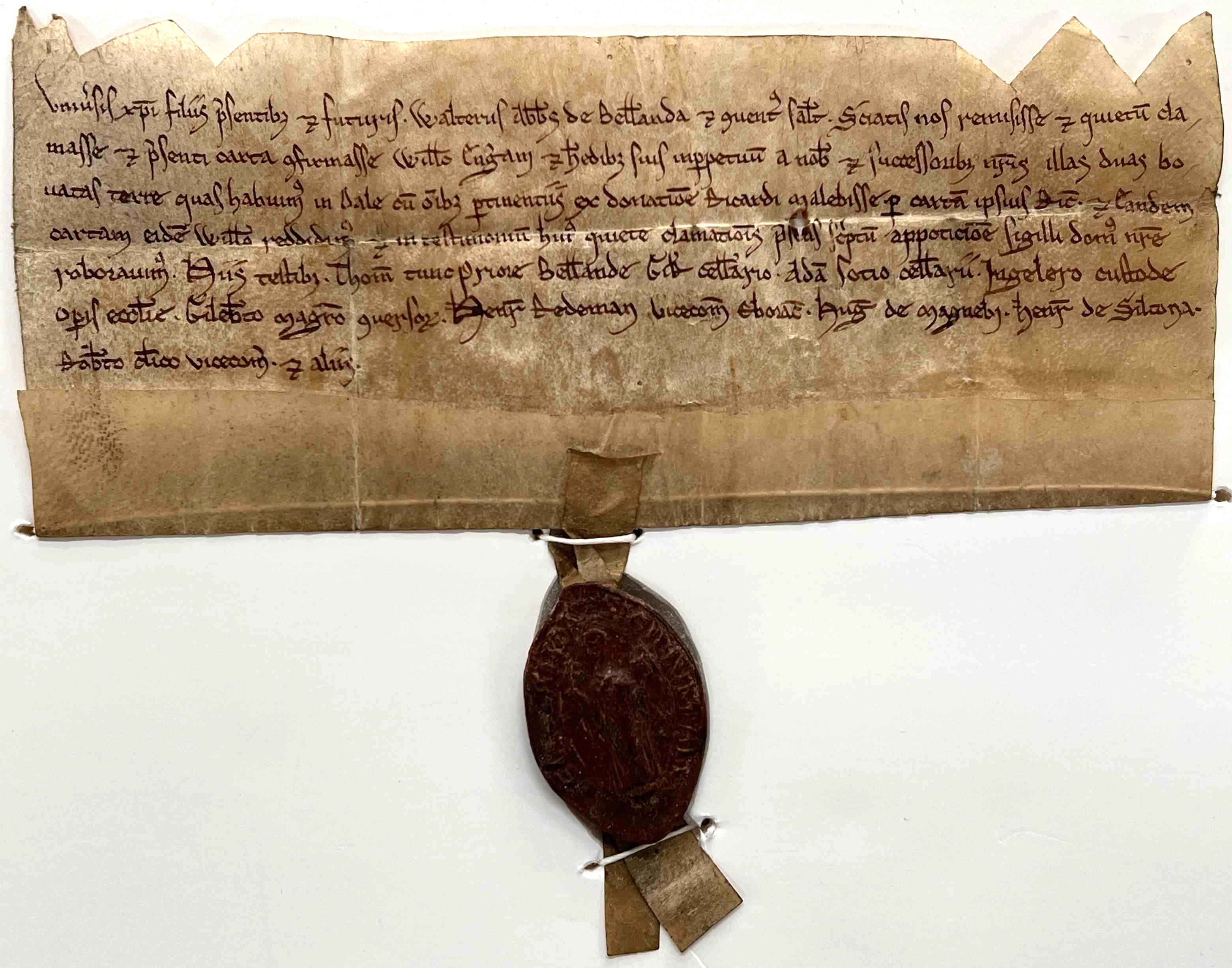
Release by Walter the abbot and the convent of Byland to William Engeram, of all right in two bovates of land in Dale, which they had by grant of Richard Malebisse, from the records of the Mauleverer family, c.1210, Latin [ZFL 3] – Wax seal depicts an abbot with crozier in one hand and book in the other
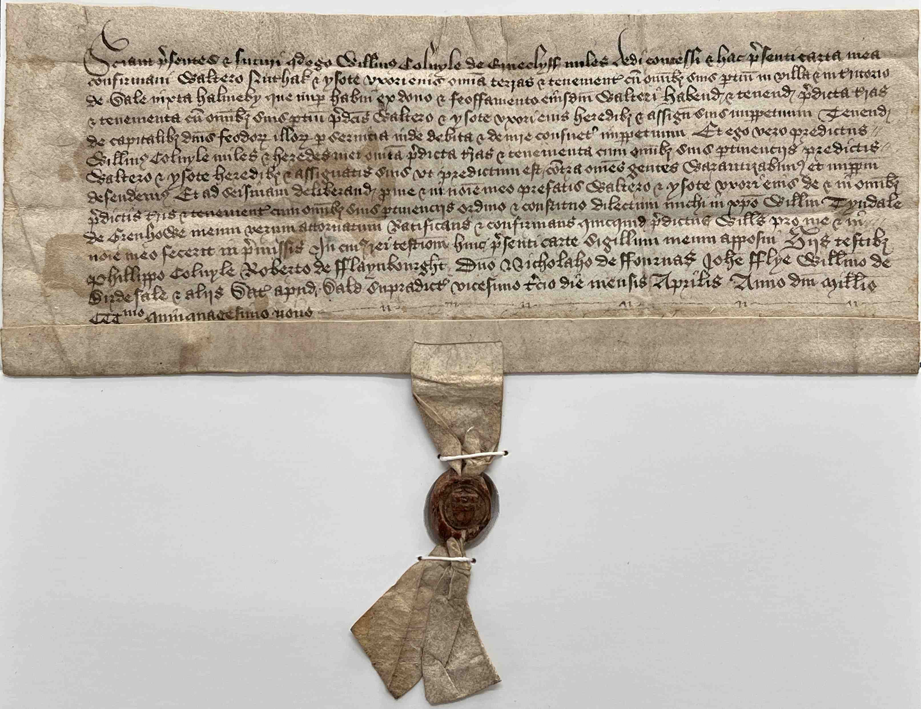
Grant by William Colvyle of Arncliffe, Knight, to Walter Nuthak and Ysot his wife, of all the lands in Dale by Hawnby, which he had by grant and feoffment of the same Walter, from the records of the Mauleverer family of Ingleby Arncliffe, 23 April 1359, Latin [ZFL 3] – Wax seal bears the Colville arms
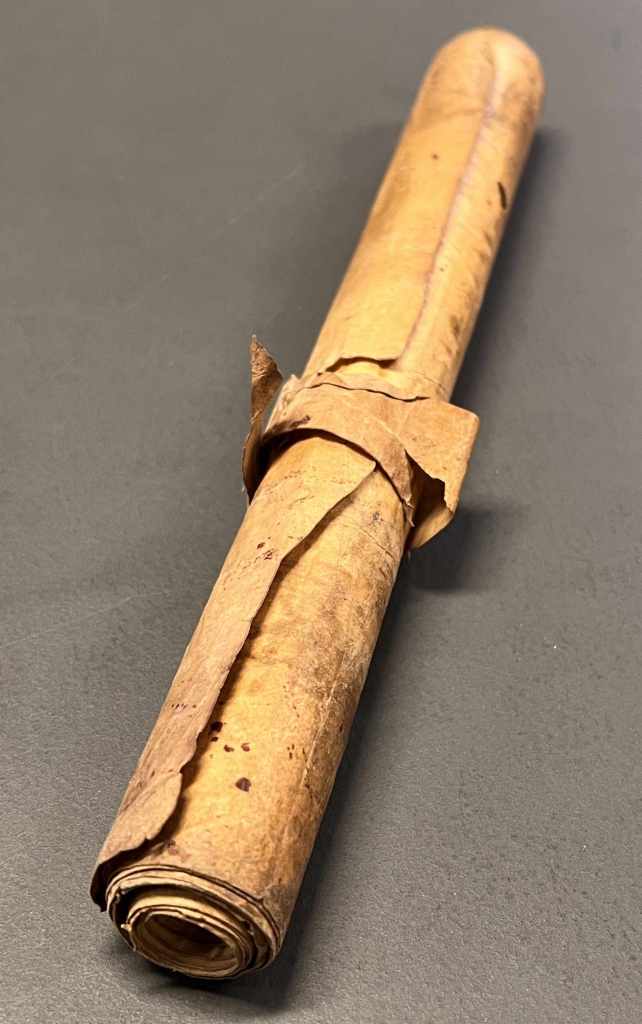
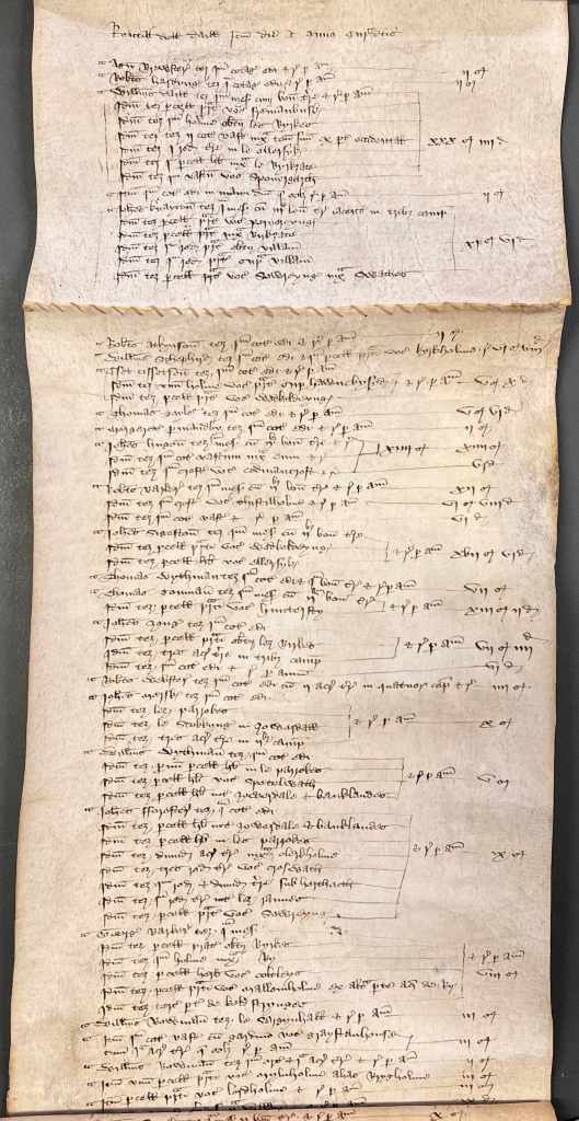
Parchment roll of rentals of Arncliffe, Dale, Thimbleby and Kirby Sigston; opened to show a rental of Dale naming all tenants and their fields, from the records of the Mauleverer family of Ingleby Arncliffe, 22 February 1434, Latin [ZFL 134]
Translation of the top section of the above rental down to the stitching joining the two membranes of parchment:
Rental of Dalemade on the feast of the Chair of St Peter (22 February 1434)
Agnes Brewster holds one built cottage and renders per annum 2 shillings.
Robert Hardyng holds one built cottage and renders per annum 2s.
William Daill holds one messuage with a bovate of land and renders per annum
The same holds a parcel of meadow called fremanbusk
The same holds one holme beneath les Byrkes
The same holds 2 waste cottages next to his tenement on the west side
The same holds one rood of land in le Ellersyk’
The same holds one parcel of grassland next to le Byrkzate
The same holds one waste called Sponergarth 30s. 4d.
Also one built cottage in the lords hands which used to render per annum 2s.
John Knayton holds one messuage with 3 bovates of land lying in 3 fields
The same holds a parcel of meadow called Pernereyng’
The same holds a parcel of meadow next Birkzate
The same holds one rood of meadow beneath the village
The same holds one rood of meadow above the village
The same holds a parcel of meadow called Sowreyng’ next to Swathes 11s.6d
Early names include Wodkeldeyng, Codmancroft, Huntersty, lez Parrokes, lez Birkes and Pernereyng. Later names are typical of enclosure, including Calf Garth, Barn Field, Clover Close, New Piece and Cow Pasture. The area was depopulated in the 16th century. Traces of stone foundations and earthworks of ridge and furrow are all that remain of the former settlement, recorded archaeologically by aerial photography.
The tithe map of 1847 (below) shows a mixture of enclosed fields and woodland. Of the 1765 acres of the township, the apportionment calculates that 180 are arable, 709 are meadow or pasture, 478 are woodland and 396 are common. The landowner is Samuel Bamford Hamer Esq. and there are seven tenants.
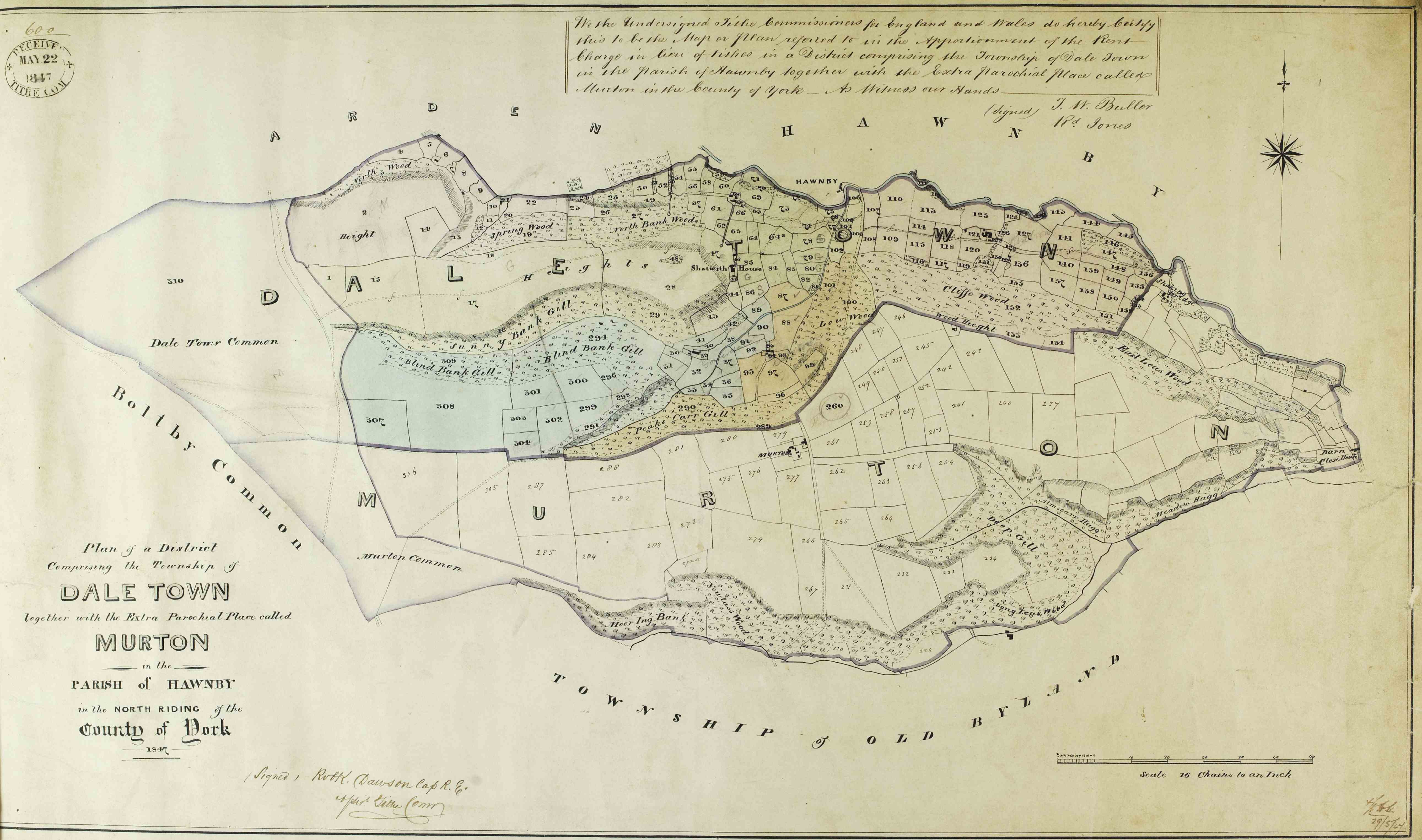
Tithe map of Dale Town and Murton, 1847 [T]
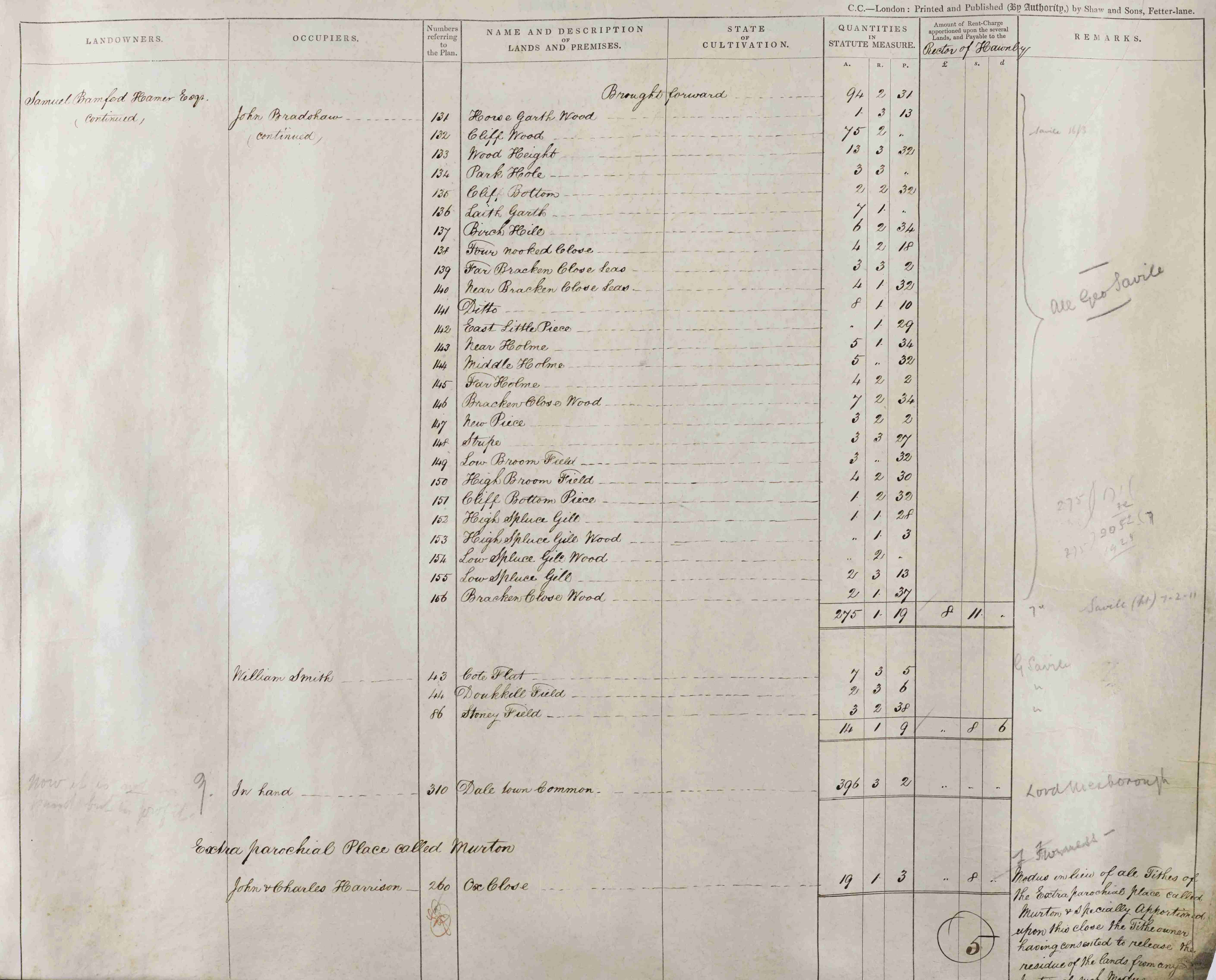
Page from the tithe apportionment for Dale Town and Murton, 1847 [T]
Tithe maps and their accompanying apportionments were produced after the Tithe Commutation Act, 1836 to identify tithable lands and calculate rent charge values in lieu of in-kind payments. They provide a highly detailed record of the fields of a parish, listing the name, acreage, land use (such as meadow or arable), owner, and occupier of every plot identified by numbers on the map.
Further reading:
Explore the Daletown and Murton tithe map and apportionment in more detail on the North Yorkshire Tithe Maps website
