
by Gail Falkingham, Record Assistant
On 31st May 2024, for Local and Community History Month, the Record Office took a pop-up archive to Easingwold Community Library with examples of historic maps, photographs and other documents relating to the town. Maps and plans are always popular items of interest at such events, as they can tell us so much about local history and changes through time. This blog has been written to showcase the range of 18th- to 20th-century maps of Easingwold held in a variety of Record Office collections. These maps are explored in chronological order below.
Contents:
- Jefferys’ map of Yorkshire, ‘The County of York Survey’d’, 1771
- Plan of West Moors Estate on the north side of New Bridge, Easingwold, 1774
- Set of five plans of the open fields of Easingwold, c.1808
- Easingwold enclosure map and award, 1812
- Copies of Easingwold tithe map, 1841 & 1843
- Historic Ordnance Survey map sheets, 1856 & 1911
- Easingwold railway plans and sections, 1886
- Further information
[Click on images below to open full-screen versions when viewing online]
Jefferys’ map of Yorkshire, ‘The County of York Survey’d’, 1771
On large, county-wide maps such as this, the mapping is not sufficiently detailed to rely on for accurate depictions of individual buildings. However, in this representation of Easingwold, the settlement and the church are clearly visible, as is the triangular road layout.

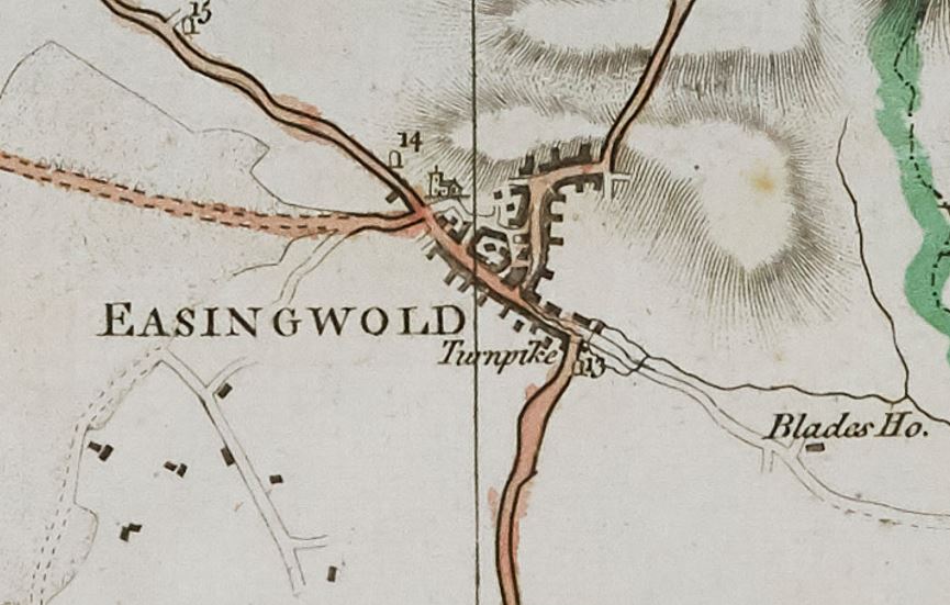
Plate 8 of Jefferys’ map of Yorkshire, ‘The County of York Survey’d’, 1771 with detail showing Easingwold [ZDU]
The Record Office historic map collection includes a number of other county-wide maps of Yorkshire and the North Riding (listed under ‘Yorkshire’ at the end of our searchroom Guide no.3 (link opens as pdf)), some of which pre-date the maps and plans in this blog. Where settlements are shown on these county-wide maps, due to the large areas covered, their depiction is often stylised.
Plan of West Moors Estate on the north side of New Bridge, Easingwold, 1774
This plan of 1774 depicts an area of land at West Moors, just over five miles south of Easingwold, at the very southern tip of Easingwold parish. The plan is from the North Riding Quarter Sessions collection, amongst papers relating to the building, maintenance and repair of bridges [QAB]. The land adjoins the west side of the modern A19 road, to the east of the village of Linton on Ouse by what is now known as Blue Bridge. The bridge crosses New Parks Beck, between Hunting Lodge Farm to the east and Newton Grange and Demesnes Farm to the west. This area can be seen in its wider context in the bottom right hand (south-east) corner of the first edition six inch to one mile Ordnance Survey map of 1856 (Yorkshire sheet 139).
It is titled ‘Plan of an estate called West Moors on the north side of the New Bridge as divided between Sir J.T. Long bt. and Giles Earle esq. in the year 1774‘ and drawn in colour at a scale of 16 chains to one inch on paper measuring 7.75 x 11.75 inches [QAB(M)]. The lands of Giles Earle are shown in green and those of Sir James Long in yellow.
The plan is part of a file of documents concerning the question of who held responsibility for repairing the bridge – the adjoining landowners, or the North Riding of the County of York?
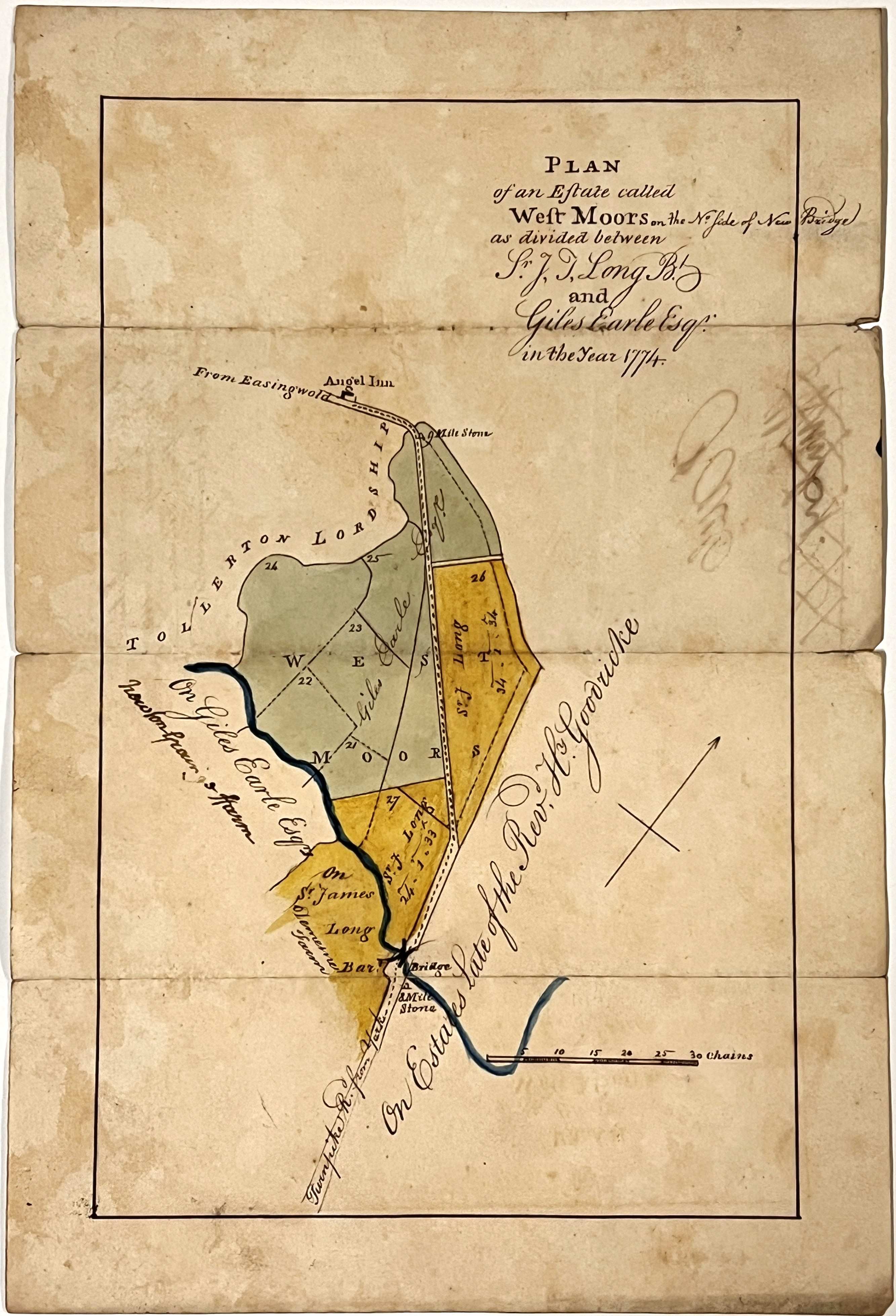

Front and reverse of ‘Plan of an estate called West Moors on the north side of the New Bridge as divided between Sir J.T. Long bt. and Giles Earle esq. in the year 1774’ [QAB(M)]
One of the related documents (see below), was written in 1802, when the bridge was in need of repair and a legal opinion was sought as to who would be liable. It records that around 1773, the year prior to the above plan being made, the two landowners, Long and Earle, had voluntarily repaired and enlarged the bridge, as per a decree made 120 years earlier in the Court of Exchequer on 20 June 1653, when the bridge was originally erected as a horse and foot bridge. At that time, any maintenance and repairs were deemed the responsibility of the adjoining landowners or occupiers. The decree ordered that:
“a convenient Bridge for Horse and Foot over the water called the Fleet in the ordinary road and usual way leading between York and Thirsk near a place called the Grayneige should be made with a foundation of Brick or Stone of such convenient height that the Bridge be not overflowd and that the scaffold thereof be of substantial Planks of Oak and paved upon the said Planks with earth and Stone for the better preservation thereof and a convenient causeway 20 feet of either side of the said Bridge raised two feet with earth and so from time to time repaired and maintained at the charge of the owners or occupiers of the lands next adjoining on both sides of the said Bridge respectively…”.
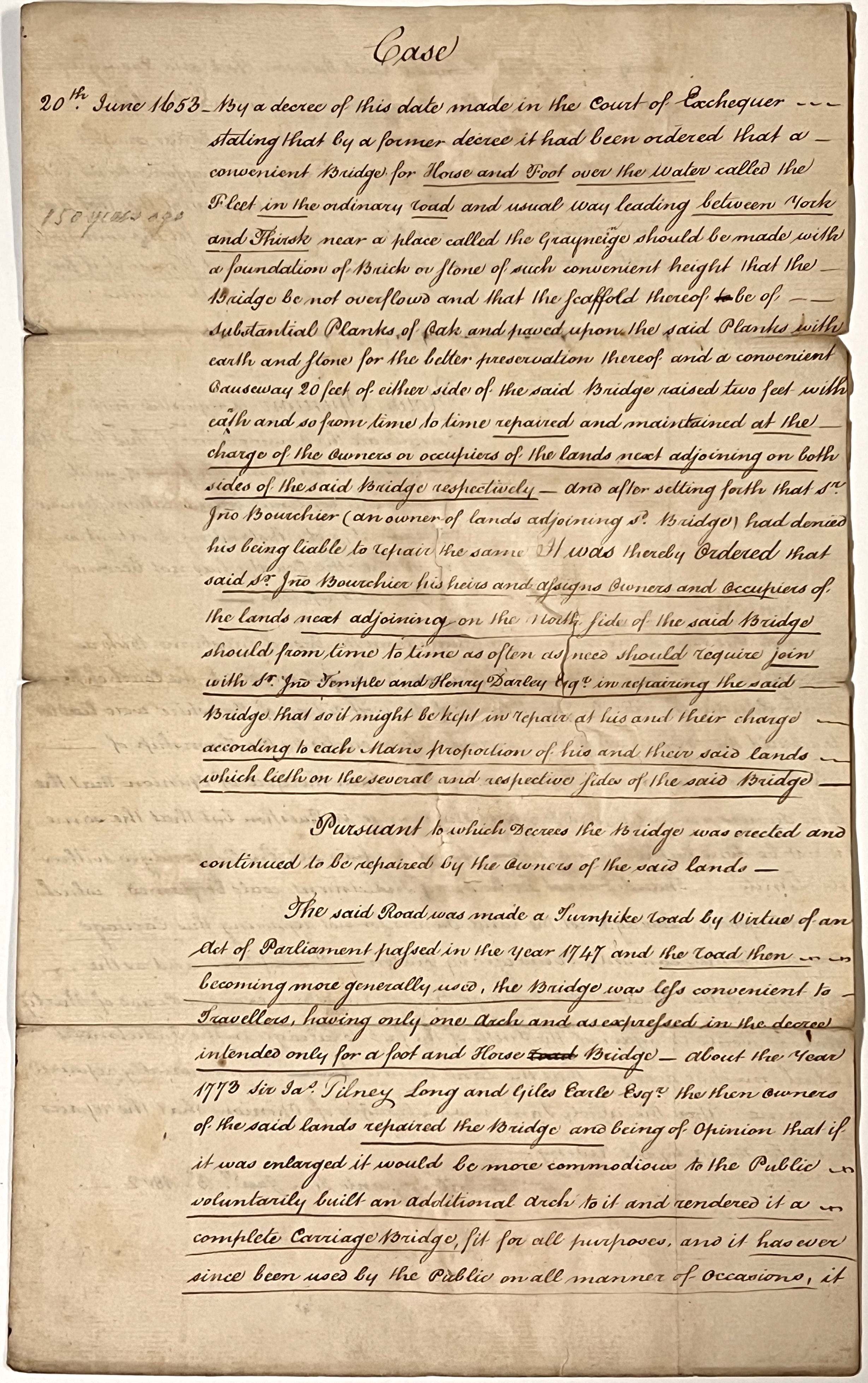
Case and opinion relating to responsibility for the maintenance of Blue Bridge in the parish of Easingwold, 3 January 1802 [QAB]
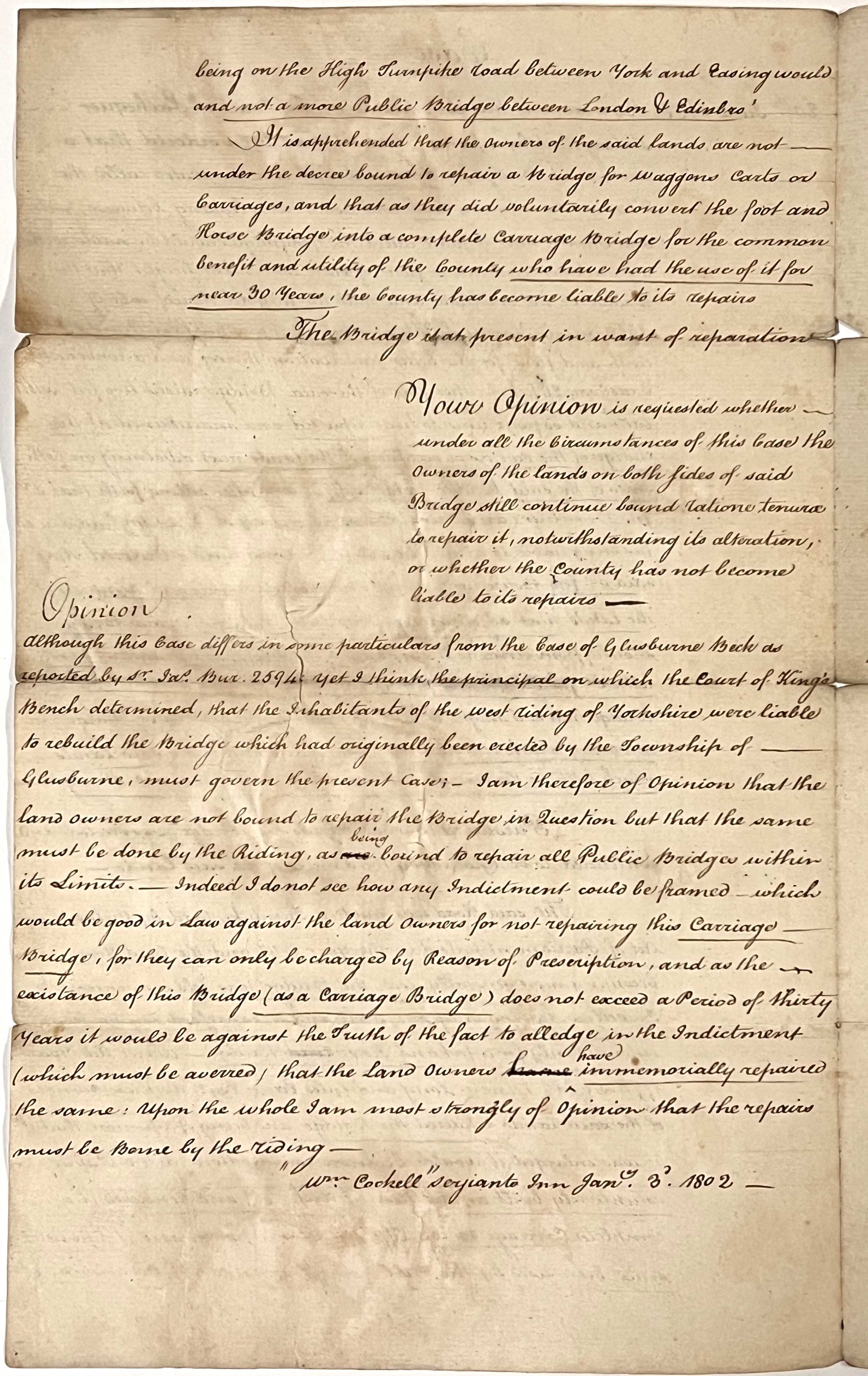
In 1747, by virtue of an Act of Parliament, the road was made a Turnpike. Consequently, the bridge required repairs and needed to be upgraded to a carriage bridge to make it suitable for heavier traffic. As mentioned above, the adjoining landowners (as shown on the above plan), voluntarily undertook such work 25 years or so later, in 1773:
“the road then becoming more generally used, the Bridge was less convenient to Travellers, having only one arch and as expressed in the decree intended only for a foot and Horse Bridge. About the year 1773 Sir Ja[me]s Tilney Long and Giles Earle Esqr. the then owners of the said lands repaired the Bridge and being of opinion that if it was enlarged it would be more commodious to the Public voluntarily built an additional arch to it and rendered it a complete Carriage Bridge fit for all purposes and it has ever since been used by the Public on all manner of occasions it being on the High Turnpike road between York and Easingwould and not a more Public Bridge between London & Edinbro’“.
By 1802, after the bridge had been upgraded and subsequently used for common benefit for a period of nearly thirty years, the opinion of William Cockell, of Serjeant’s Inn (in the City of London), was that the landowners should no longer be held liable for repairs and instead, the responsibility should lie with the North Riding:
“It is apprehended that the owners of the said lands are not under the decree bound to repair a Bridge for Waggons, Carts or Carriages, and that as they did voluntarily convert the foot and Horse Bridge into a complete Carriage Bridge for the common benefit and utility of the County who have had the use of it for near 30 years, the County has become liable to its repairs”.
Set of five plans of the open fields of Easingwold, c.1808
The Record Office holds a set of five plans depicting the open fields of Easingwold: Church Field (in two parts, to the west of the town), Craike Field (to the east), Mill Field (to the north) and Stone Field (to the south) [ZMI 35, see images below]. The plans are drawn on paper and are all of a similar size; the largest, of Craike Field, measures 27 x 15.5 inches and the smallest, of Stone Field, measures 20.25 x 16 inches.


Two plans of parts of Church Field, Easingwold, undated, c.1808 [ZMI 35]
They bear neither date nor name to indicate who drew them and when. There are no elaborate cartouches decorating the plans, just a simple field name on each, encircled with a flourish and all have a basic north point. The scale is noted on the map of Mill Field as ‘3 Chains in one Inch‘, the others have no scale marked but appear to be similar.
Plans of Craike Field and Mill Field, Easingwold, undated, c.1808 [ZMI 35]
Some of the roads are named and their widths noted in feet. There are also various other measurements, field numbers, field names and personal names written on the plans, plus references to ‘old inclosures’. This suggests that the plans are concerned with the reorganisation of the landscape surrounding the town as part of the enclosure of the former, medieval open fields, when individual strips were consolidated into new fields, and new boundaries and roads laid out, a process that was taking place at the beginning of the 19th century (see below). The names of the open fields are still noted on the later, first edition Ordnance Survey map of 1856 (Yorkshire sheet 121), which helps to identify their location relative to the area of settlement (see below).
Plan of Stone Field, Easingwold, undated, c.1808 [ZMI 35]
Some areas of the plans are coloured with a green wash and, although there is no map key, it appears that these green areas denote land that was previously enclosed, presumably by an earlier, private agreement.
Interestingly, nine, very similar, late-18th/early-19th-century plans of the open fields of Easingwold can be found within the collections of the Yorkshire Archaeological and Historical Society (YAHS) held at the University of Leeds Libraries, Special Collections, ref YAS/MD382/1-9. These plans are reproduced in black and white on pages 105-112, and one in colour on the back cover, of the publication: ‘Ye dear Object of my Affections’: The Diary of William Lockwood of Easingwold 1778-1836 – From 1st January 1796 to 30th September 1797, edited by Helen Kirk, published by the Forest of Galtres Society, 1996. Plans of the Church Field in 1797 and Mill Field about 1800 are reproduced in black and white between pages 16 and 17 of Geoffrey Cowling’s 1968 The History of Easingwold and the Forest of Galtres. Copies of both these publications are held by the Record Office*.
The nine YAHS plans referred to above are drawn at the same scale of three chains to one inch as the five plans held by the Record Office and depict the same fields. The nine plans are in two groups, thought to have been made about ten years apart, and they appear to be more detailed, showing individual strips and furlongs, which are named and numbered within each field, and some are coloured. One of the plans of Craike Field from the earliest group is dated May 1796 and there is a clue to the cartographer on the early Church Field map on which is noted ‘W Lockwood delin’ (drawn by W Lockwood) (Kirk ed. 1996, pp.113-114).
It is suggested that the set of five plans of the open fields held by the Record Office is dated slightly later than those of the YAHS, to circa 1808 around the time of the Enclosure Act (see below). It is interesting to compare these five plans with the set of nine and with the 1812 enclosure map (see below) as there are both similarities and differences.
Enclosure map and award, 1812
A private Act of Parliament for ‘inclosure’ at Easingwold was passed in 1808 [Act 48 Geo III c.26]. The enclosure award recording the subsequent changes made to boundaries, roads, drains, landholdings and ownership is dated 12 November 1812, and has an accompanying map of the same date (see [I – NRRD 14] below).

Extract from the Easingwold enclosure map entitled: ‘A Plan of the Allotments & Partitions at Easingwold referred to by the Award of the Commissioners appointed under an Act of parliament passed in the 48th year of the Reign of King George III intitled an Act for inclosing Lands in the Township of Easingwold in the North Riding of the County of York, John Humphries surveyor, 1812’ [I – NRRD 14]
There are two copies of the enclosure map and related award within Record Office collections, one set as part of the Easingwold Parish Council records, the map being drawn on parchment and measuring 43 x 37 inches [PC/EAW]. The other copy was enrolled within the North Riding Register of Deeds, the award written into one of the large, leather-bound Register volumes [NRRD DO/18/92-124, see images below]. The accompanying map was drawn on paper on linen, measuring 37 x 40 inches [NRRD no.14, see image above]. Under the title in the top left corner, this plan is signed on 12th November 1812 by the two Enclosure Commissioners, Thomas Scott and John Tuke. The ‘Remarks’ in the top right corner note the following colour conventions:
- Leasehold Land coloured Red
- Freehold Land coloured Green
- Copyhold in the Manor of Easingwold & Newby coloured Blue
- Copyhold in the Manor of Easingwold in the ArchDeaconry of Richmond coloured Yellow


Pages from the North Riding Register of Deeds volume DO containing the handwritten, enrolled copy of the Easingwold enclosure award, dated 12 November 1812 [NRRD DO/18/92-124]
Copies of Easingwold tithe map, 1841 and 1843
Tithes were payments by parishioners to support their parish church and its clergy. Traditionally, tithes were paid ‘in kind’ and based on one tenth of one’s annual produce. This produce included crops arising from the ground, such as corn, hay, vegetables and wood, which were known as great tithes. These great tithes were usually paid to the rector of the parish, who was often a lay person (non-clergy) known as the impropriator of tithes, who had no religious responsibilities, though in some cases they provided for a curate. The rector was not always resident in the parish and might lease out the right to collect the great tithes to others more locally based.
Livestock nourished by the ground, such as the young of cattle, sheep, pigs and geese, plus associated animal produce, including milk, eggs and wool, as well as the profits of labour, for example from mills and fishing, were known as small tithes and usually paid to the vicar of the parish.
Tithe maps and apportionments were produced as a result of the Tithe Commutation Act of 1836, which led to the conversion of the traditional ‘in kind’ payments into monetary payments. These cash payments were known as the tithe rent-charge and were calculated according to the prevailing price of grain, subdivided between property owners according to the valuation of their properties.
Plot numbers link each parcel of land shown on the tithe map to the descriptions in the apportionment, which record how much tithe rent-charge was due on each plot as well as the names of the respective landowners and occupiers (tenants), field names, land use and acreages.
The parish copy of the Easingwold tithe apportionment of 15 April 1840 [PR/EAS/109] and associated tithe map of 1841 [PR/EAS/110], surveyed by Henry Scott, are held by the Borthwick Institute for Archives, York.
The Record Office holds a similar plan of part of the township of Easingwold surveyed at a scale of six chains to one inch by H. Scott, dated 1841 [M15, see images below]. This folded plan is drawn on paper on linen, measuring 54 x 49 inches and bears similar field numbering to the later, 1843 tithe map copy (see below).


Extracts from a ‘Plan of part of the township of Easingwold in the North Riding of the County of York’, surveyed by H. Scott, 1841 [M15]
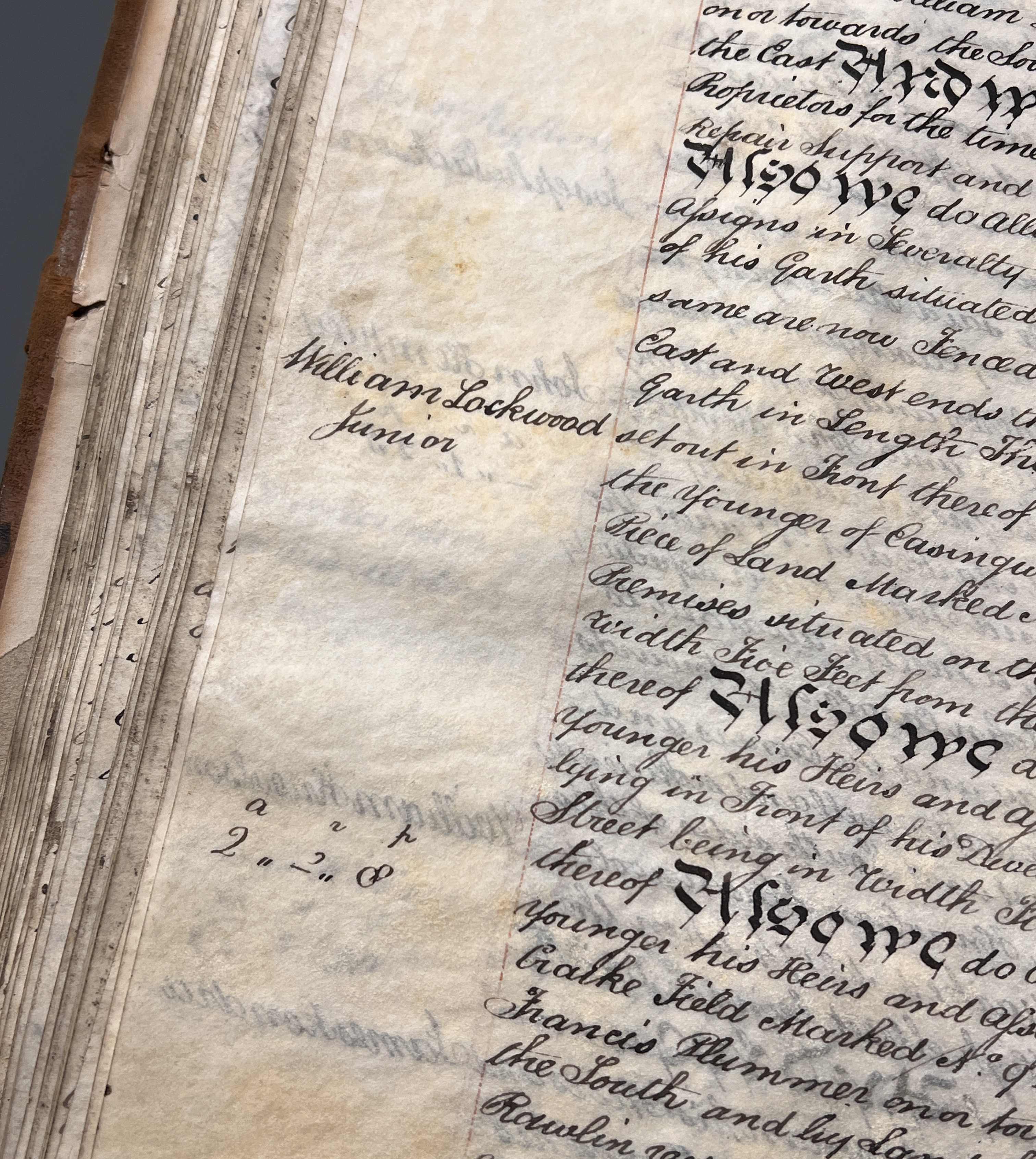
A later copy of the Easingwold tithe map was recently deposited with the Record Office. This was made for the use of the lessees of the great tithes and surveyed by Henry Scott of Oulston in 1843 [M, see image below]. The map is accompanied by a copy of the associated tithe apportionment of 1840, handwritten onto the pages of a pre-printed, bound rate book. The introduction to this apportionment records that the Lord Bishop of Chester, as appropriator of the great tithes, has leased out the great tithes to the lay impropriator William Lodge Rocliffe of Easingwold, Doctor of Medicine, his executors or assigns.

Extract from copy of the tithe map, ‘made for the use of the Lessees of the Great Tithes’, drawn by Henry Scott of Oulston, 1843 [M]

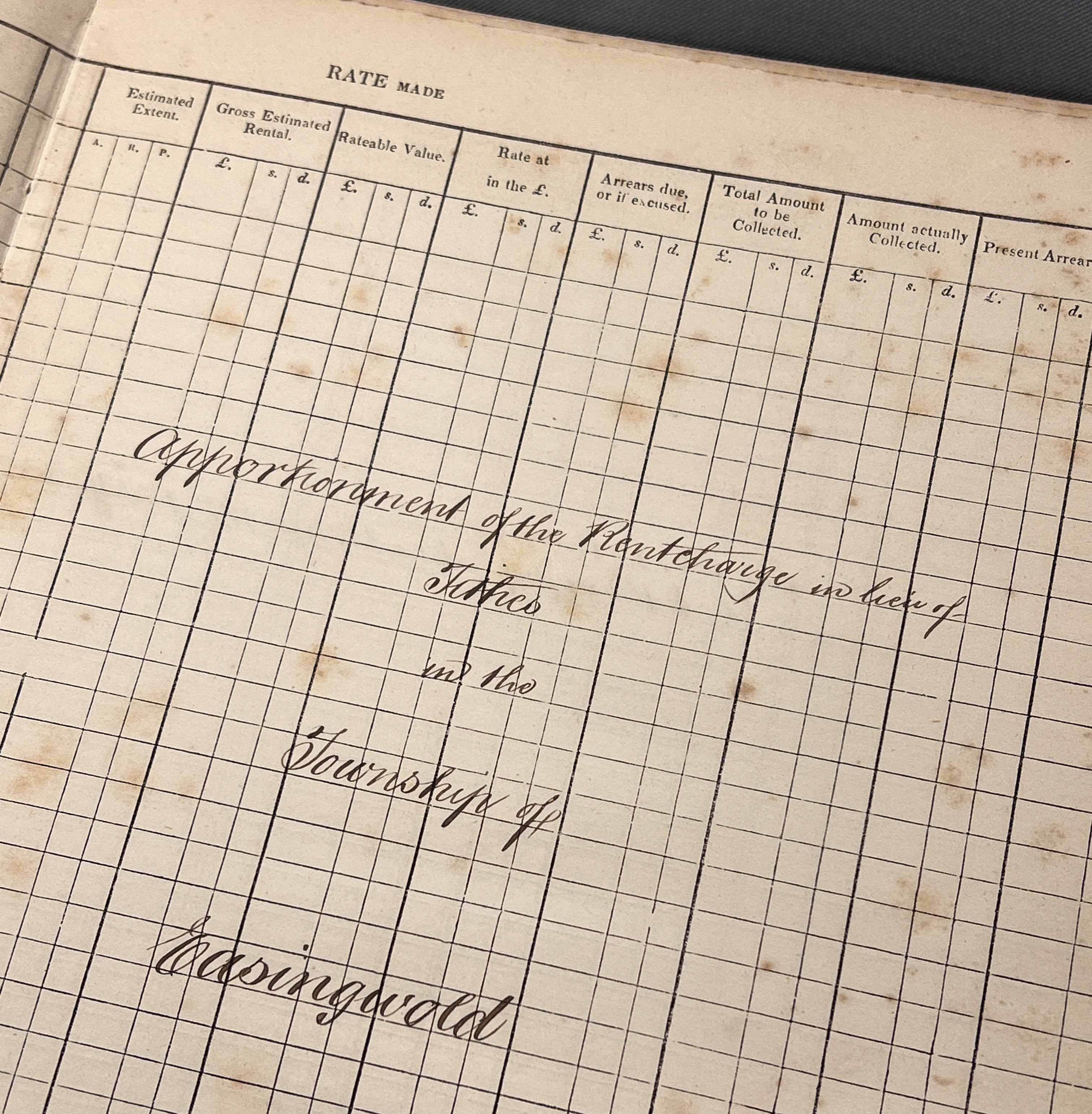

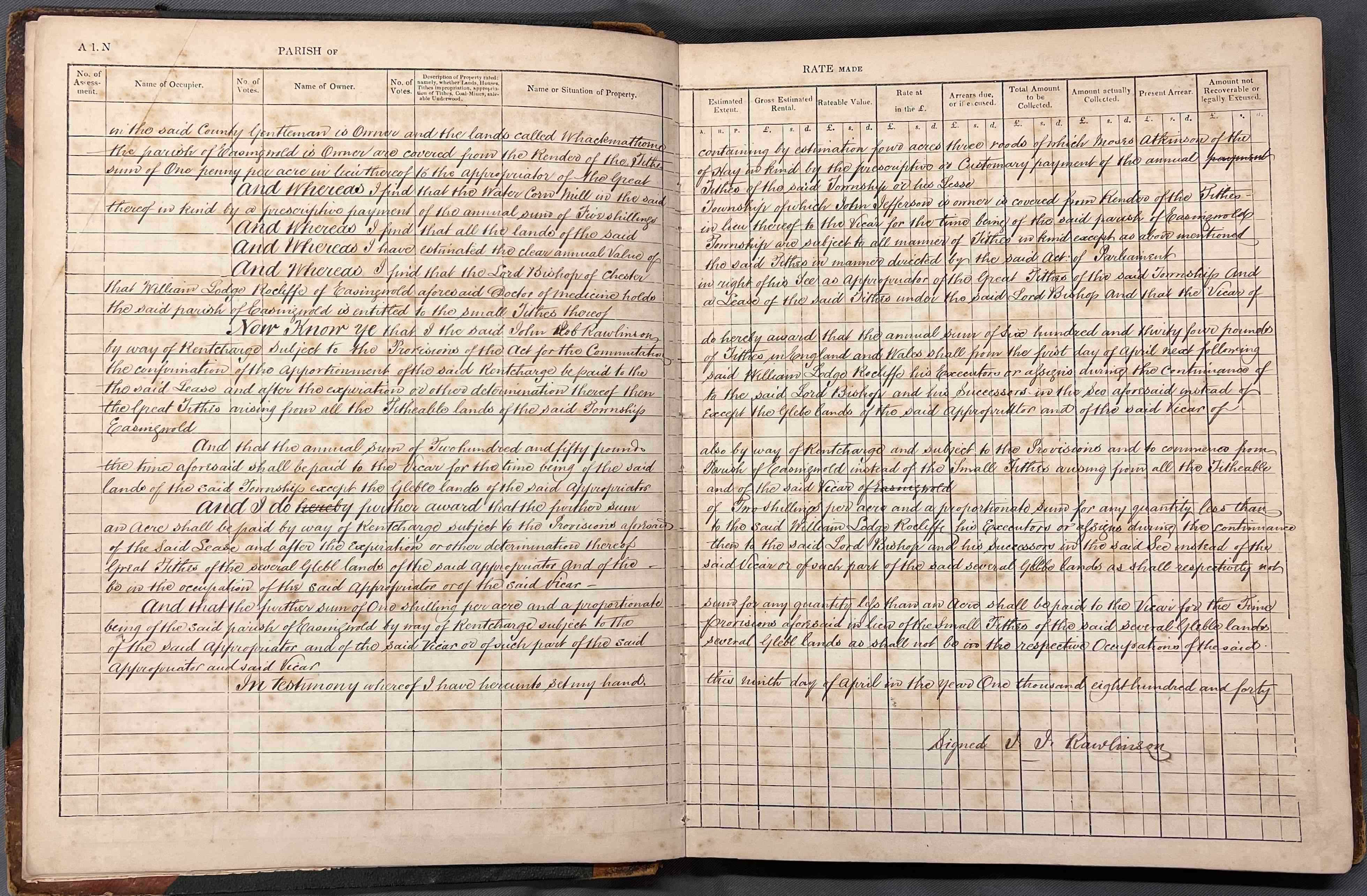


Examples of pages from the copy of the Easingwold tithe apportionment of 9 April 1840, including the four-page introduction, handwritten into a pre-printed, bound rate book.
The annual values of the rent-charge payments in lieu of tithes are given in the introduction to the tithe apportionment, as are the measurements of the extent of titheable lands in the township. The annual sum of £634 (equivalent to just under £54,200 today according to the Bank of England inflation calculator) is to be paid to William Lodge Rocliffe, his executors or assigns during the continuance of his lease, and after the expiration or other determination then to the Lord Bishop of Chester and his successors in the see, instead of the great tithes arising from all the titheable lands of the township except the glebe lands of the said appropriator (the Lord Bishop) and of the vicar of Easingwold. Instead of the small tithes, the annual sum of £250 (equivalent to just over £21,300 today) is to be paid to the vicar.
By virtue of the provisions of the 1808 Act for inclosing the commons and waste of the township of Easingwold (see above), 565 acres, 2 roods and 25 perches of land are absolutely exempt from payment of all tithes great and small. Land that is subject to tithes amounts to 6118 acres and 9 perches, of which 4437 acres, 1 rood and 24 perches are arable land, 1525 acres, 2 roods and 27 perches are meadow or pasture and 154 acres, 3 roods and 38 perches are woodland.
Historic Ordnance Survey map sheets, 1856 and 1911
The Ordnance Survey (OS) is the national mapping agency for Great Britain. From the 1840s to the 1890s, the OS undertook a county by county survey of the whole country to produce their ‘County Series’ maps at both a six inch to a mile (1:10,560) and a more detailed twenty-five inch to a mile (1:2,500) scale. From then onwards, individual map sheets were produced in a series of revised editions, published at regular intervals.
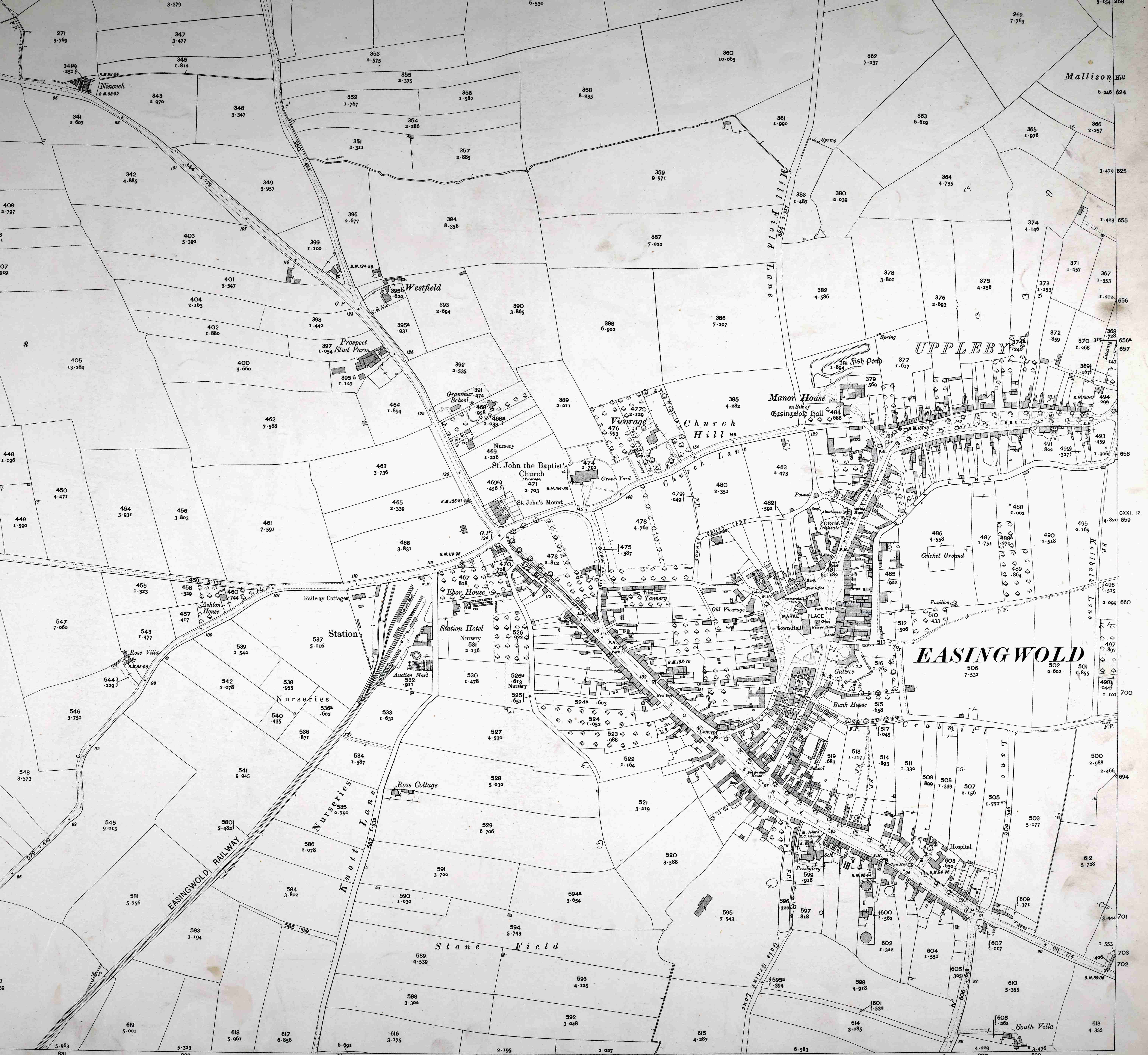
The first edition of the six inch to one mile OS sheet covering Easingwold was surveyed in 1852-1853 and published in 1856 (Yorkshire Sheet 121, see image below).

Extract from first edition six inch to one mile Ordnance Survey map Yorkshire Sheet 121, surveyed 1852/1853, published 1856, showing the town and surrounding fields
The second edition of the 25 inch to one mile OS sheet covering Easingwold was revised in 1910 and published in 1911 (Yorkshire Sheet CXXI.11, see image below).
Extract from the second edition 25 inch to one mile Ordnance Survey map Yorkshire Sheet CXXI.11, revised 1910, published 1911 showing the town and Easingwold railway line and station to the west
The National Library of Scotland website makes historic Ordnance Survey map sheets available online.
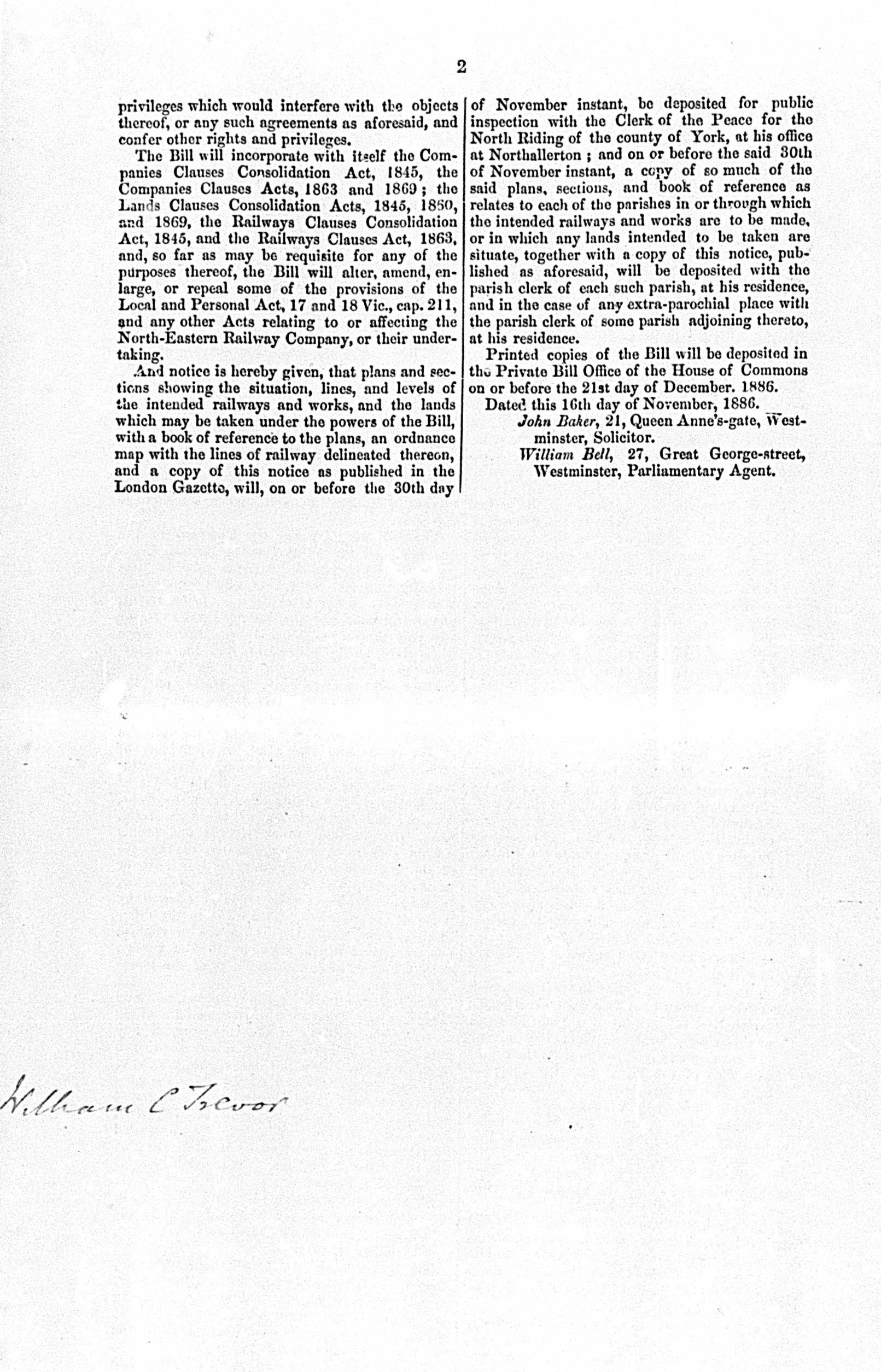
Easingwold railway plans and sections, 1886
The privately-owned Easingwold railway, which operated from 1891 to 1957, ran for 2.5 miles between a station to the west of Easingwold and a station located a short distance to the south-west, to the north-east of Alne village. Further information about the Easingwold railway can be found on the LNER Encyclopedia webpage and in Hartley (1991).
The Record Office holds plans of railways that were deposited with the Clerk of the Peace as part of the North Riding Quarter Sessions collection [QDP]. Records relating to Easingwold include plans and sections of the railway line with an associated Book of Reference dated November 1866 [QDP M257, see images below].

Easingwold Railway plans and sections, 1886 [QDP M257]
In the top right hand corner of the above plan is written:
“These plans and sections with Ordnance work to each of which I have signed my name were lodged in the office of the Clerk of the Peace of the North Riding of the County of York at Northallerton in the said Riding on Tuesday the Thirtieth day of November 1886 between the hours of ten and eleven in the forenoon.
signed by William C Trevor, Deputy Clerk of the Peace of the North Riding of the County of York“
The Book of Reference identifies all owners, lessees and occupiers with a qualifying interest in land and property affected by the railway scheme. All persons and organisations are listed by parish against each of the numbered parcels of land that are described in the Book of Reference and shown on the associated plans.


Pages from the Easingwold Railway Book of Reference, November 1886, including notice that application is intended to be made to Parliament in the ensuing session [1887] for leave to bring in a Bill for the incorporation of the Easingwold Railway Company and for construction of the Railway &c [QDP M257]
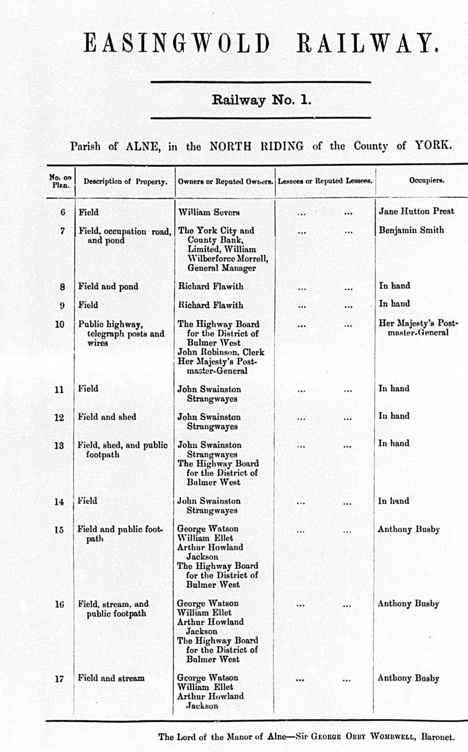


Pages from the Easingwold Railway Book of Reference, November 1886 identifying all owners, lessees and occupiers with a qualifying interest in land and property affected by the railway scheme [QDP M257]
Further information:
Read our related blog pages: Introduction to historic maps and plans, Guide to historic map regression (featuring a case study for Alne village), Glebe, terriers, tithes and enclosure and Enclosure in the landscape: a case study from Harome, near Helmsley
Listings of historic maps held by the Record Office can be found in our searchroom Guide no.3 (opens as pdf) and also Guide no.4: North Yorkshire & North Riding enclosure awards and related documents (opens as pdf). Printed copies of these Guides are available from our online shop.
A list of North Yorkshire and North Riding plans of railway lines and buildings available for consultation at the Record Office can be found in our searchroom Guide no.8 (opens as pdf) and is available in print from our online shop.
To find other records relating to Easingwold held at the Record Office, search our online catalogue.
To find out more about enclosure, read The National Archives Research Guide on ‘Enclosure awards and maps’. For tithes and tithe maps, read The National Archives Research Guide on ‘Tithes’
Cowling, G.C. 1968 The History of Easingwold in the Forest of Galtres. Huddersfield/The Advertiser Press Ltd.
Hartley, K.E. (revised Redman, R.N.) 1991 The Easingwold Railway. Locomotion Papers 46. Oxford/The Oakwood Press.
Kirk, H. (ed.) 1996 ‘Ye dear Object of my Affections’: The Diary of William Lockwood of Easingwold 1778-1836 – From 1st January 1796 to 30th September 1797. Forest of Galtres Society.
Page, William (ed.) 1923 ‘Parishes: Easingwold’, in A History of the County of York North Riding: Volume 2, British History Online.
* I am most grateful to Mr Brian Taylor of Easingwold for drawing my attention to the YAHS maps of the open fields and their publication.
