
By Gail Falkingham, Record Assistant
Introduction
The township of Harome has an interesting agricultural history, which can be traced through a fine collection of historic maps dating back to the 18th century from the Feversham/Duncombe of Duncombe Park, Helmsley Records [ZEW]. The history of the open-field system and later enclosure can be further explored through a pains book of the manor court, the enclosure award and plan, tithe apportionment and plan, as well as historic aerial photographs, listed building and archaeological records.
Prior to 1863, the township of Harome was part of the parish of Helmsley in the historic North Riding of Yorkshire. A nucleated village with medieval origins at the centre of the township operated an open-field system, whilst the demesne lands of the Lord of the Manor surrounded a moated Old Hall to the west. Map evidence and the manor pains book indicate that areas of this open-field system survived into the later-18th century, by which time piecemeal enclosure by agreement was taking place. This was followed by Parliamentary enclosure of Harome Common in 1816 and the laying out of new drains and roads. The open fields had disappeared by 1830 as a result of enclosure by private agreement, and a number of new farmsteads were created in outlying areas of the township.
Background to enclosure
Prior to enclosure, the farmland of a manor was usually divided into a number of large, open fields, cultivated on a two-, three- or four-field system of crop rotation. This open field system was administered by a manorial court. The lord of the manor would have their own land, known as the demesne farm.
Within each open field, tenant farmers were allocated a number of strips to cultivate; each tenant had several strips spread across the manor. The crops they grew each year would follow the communal cycle of rotation for each field. In addition, they had certain rights over common or waste land, such as for grazing animals and collecting fuel. Each year, a different field would be left uncultivated and used for grazing animals, whose manure would fertilize the land.
The process of enclosure usually involved the consolidation and redistribution of the dispersed strips of the open fields and the division of areas of common and waste into new fields, enclosed by hedges, fences or walls. What had been large areas of communally-farmed land were divided into smaller fields farmed by individuals, a practice which became widespread by the 18th and 19th centuries.
Enclosure could be piecemeal and take place at different times. Therefore, there may be a number of phases of enclosure over different areas within the same township or parish. Enclosure could take place publicly or privately, informally or formally, the latter by written agreement between all parties or Act of Parliament. Evidence of formal enclosure usually comprises a written enclosure award accompanied by a map, and an associated Act of Parliament where relevant. Additional information for enclosure may be found in manorial records, historic maps and plans and from archaeological evidence.
Location, topography and early history
The township of Harome lies approximately three miles to the south-east of the historic market town of Helmsley at the south-western foot of the North York Moors. The township is bounded by the River Rye to the west and on all other sides by the neighbouring townships of Beadlam, Nawton, Wombleton, East Newton and Nunnington.
The village of Harome is first mentioned in Domesday Book in AD 1086 and lies central to the township on a main street aligned east to west (Page ed 1914). There is also a north-south axis of properties at the western end parallel to Riccal Beck, an offshoot from which forms the mill race and pond associated with a water mill dating from the 13th century (NYHER MNY 24939).
A medieval moated site and old hall in Harome Haw to the west of the township, known as Hall Garth, survived as earthworks until c.2009 (NYHER MNY 1336). A later manor house, Harome Hall, stood at the western end of the village (NYHER MNY 1350). It is here that the manor court was formerly held. The ruins of this late-17th-century tied-cruck frame timber building were dismantled in the early 1970s and reconstructed at the Ryedale Folk Museum in Hutton le Hole.
The majority of the township lies around the 40m contour, with land to the north rising up to 70m above sea level towards the North York Moors. It is traversed from north-west to south-east by Riccal Beck adjacent to which were the Riccal Ings in the south-east. A large part of the eastern side of the township was an area of low-lying wasteland called Riccal Moor, formerly Harome Common.
Open-field agriculture
The earliest surviving plan of the township of Harome dates to 1782 [ZEW(M)8a, see below]. The key to this plan notes that “The open fields are colour’d round within”. These fields are centrally located close to the village, named ‘Hall Garth Field’, ‘Green Syke Field’, ‘Owman Field’ and ‘Heads Field’ to the north, suggesting that a four-field system of crop rotation may have been in operation at this time. Within these fields, individual strips are coloured and numbered, indicating the holdings of particular landowners dispersed across several fields in a variety of different furlongs. In addition, there are linear closes to the rear of each of the village properties perpendicular to the main street to the north and south. These would have been enclosed for gardens and grazing of animals.
Joseph Foord’s plan of Harome, 1782
These lands in Harome were acquired in 1695 by Charles Duncombe, who had bought the Helmsley estate from the heirs of the Duke of Buckingham in 1687. This map forms part of Joseph Foord’s survey of the entire 29,000 acre Helmsley estate for Charles Slingsby Duncombe which he began in 1779 [ZEW(M)8a]. Foord took about six years to complete the survey, the eventual bill for which came to £564.
Although Joseph Foord and his father had between them worked for the Helmsley estate for over 70 years, Joseph Foord was initially refused full payment. Duncombe withheld £133, claiming to have been overcharged, and also attempted to cast doubt over the accuracy of Foord’s surveying work. It took a case in the Court of King’s Bench before Duncombe finally paid Foord all that he was owed. Following his victory over Duncombe, Foord appears to have left the Helmsley estate never to have carried out surveying work again. After spending some time in America, Foord died in 1788 at the age of 73.
Joseph Foord’s life is the subject of the book Water from the Moors: The Life and Works of Joseph Foord by Isabel Anne McLean and published by The North York Moors National Park Authority in 2005.
Further evidence for the ploughing of former open fields can be found in oblique aerial photographs of the 1970s and 1980s showing extant earthworks of ridge and furrow at that time, which are recorded in the North Yorkshire Historic Environment Record (NYHER MNY 1352 & MNY 8912, see aerial photograph above).
Pains book from the Manor of Harome [Z.1353]
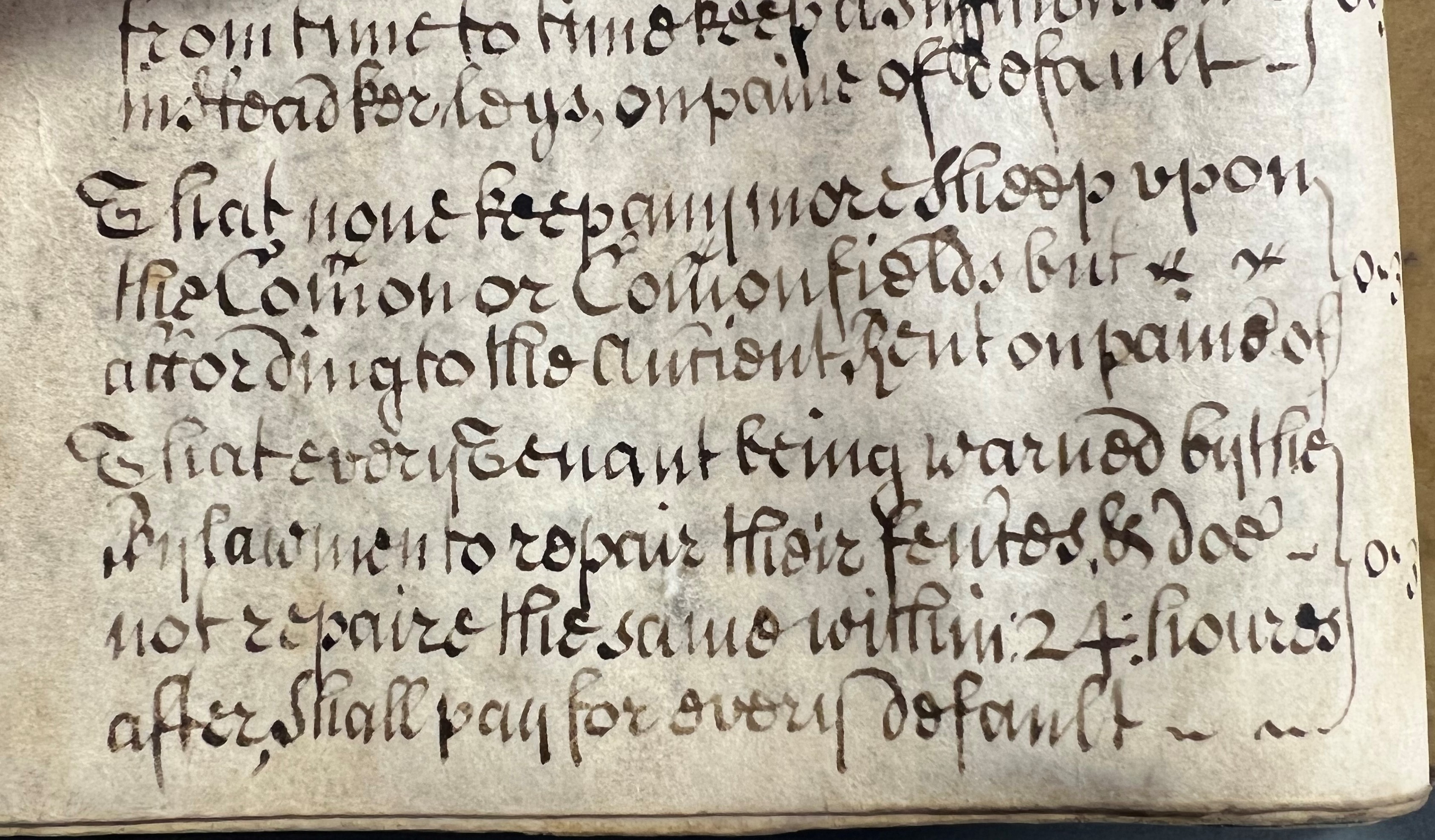
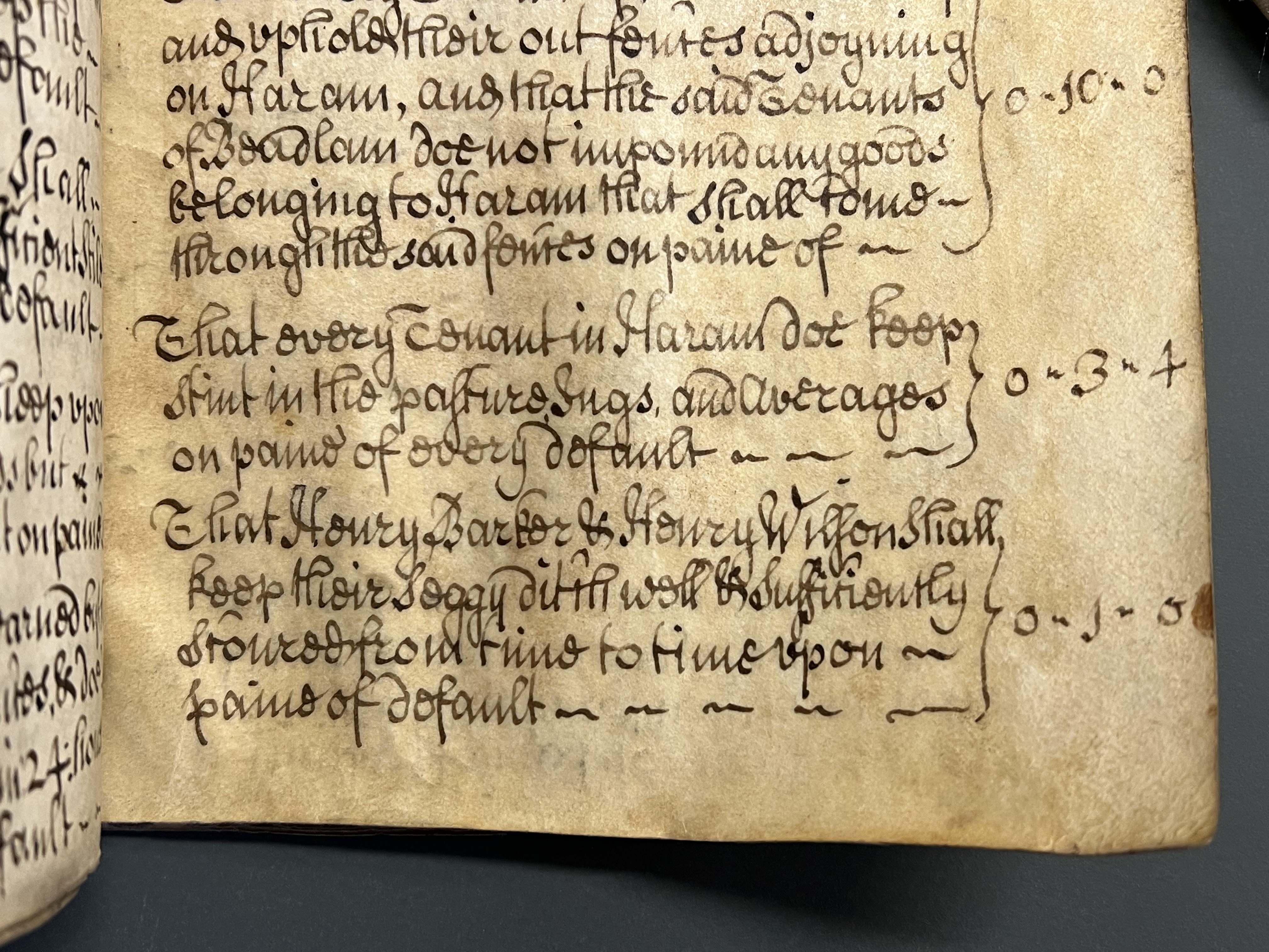
The operation of a communal open field system of agriculture in Harome can be seen in surviving manorial court records, in an 18th-century pains book signed by the Jury of the manor court held on 29 October 1737 [Z.1353]. The ‘pains’ are the rules and regulations of the manor.
The book contains reference to the Townefield, the common and fallow fields: “That every headland in the Townefield be four foot broader than the lands in the same fall, and noe more on paine of default” and “all Rams, Tups, Ridglins be taken in of the common and fallow fields on the 18 day of September or before and kept of until the 18 day of October and then may let go all such as the Maijor part of the Jury shall think fit to be put in and all the rest to be kept of until the 25 of December upon pain of every default 3s 4d”.
Livestock would be moved between the areas of common grazing and open fields at different times of the agricultural year, the locations depending upon which fields were sown and which were fallow. Farmers would usually be allowed to graze their animals on the open fields after the harvest until the middle of October, when the field would be needed for ploughing and sowing. Their droppings would provide a useful source of manure (University of Nottingham ‘Grazing, pasture and common land’ webpage).
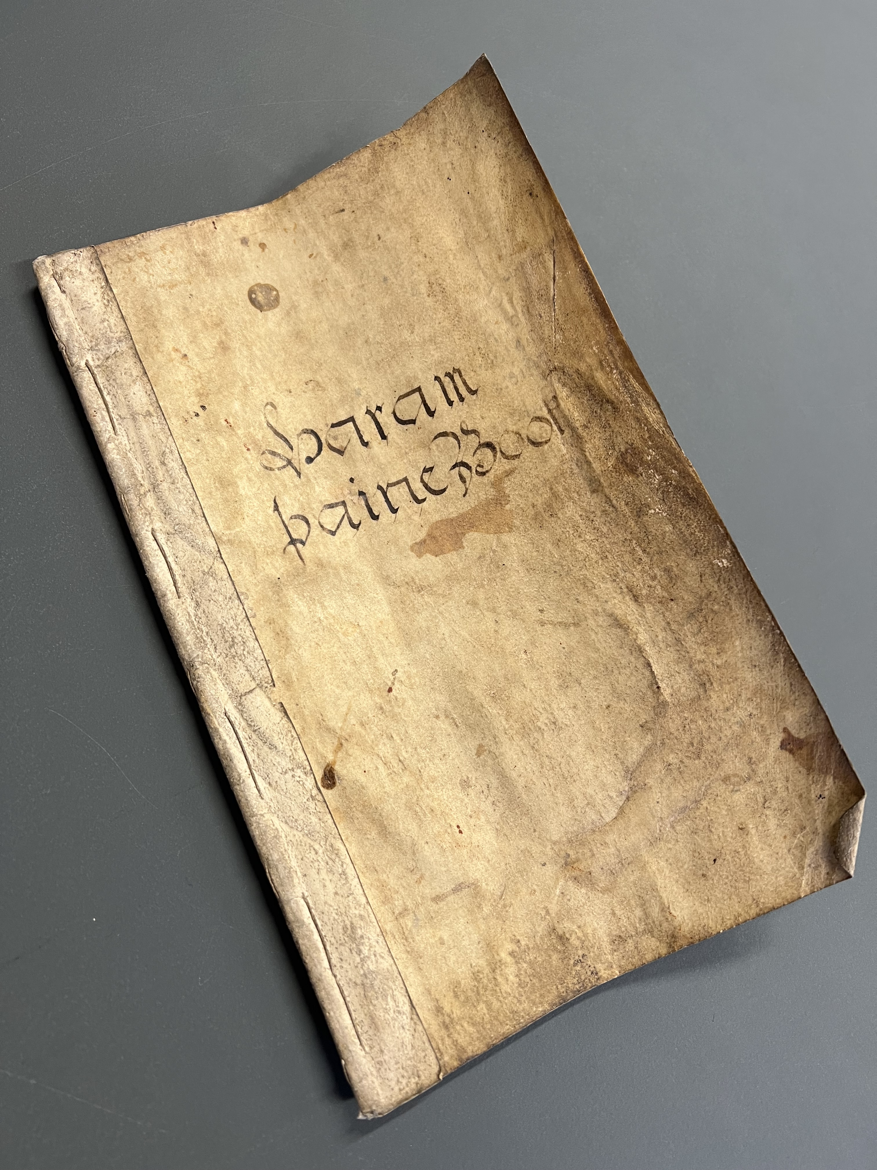
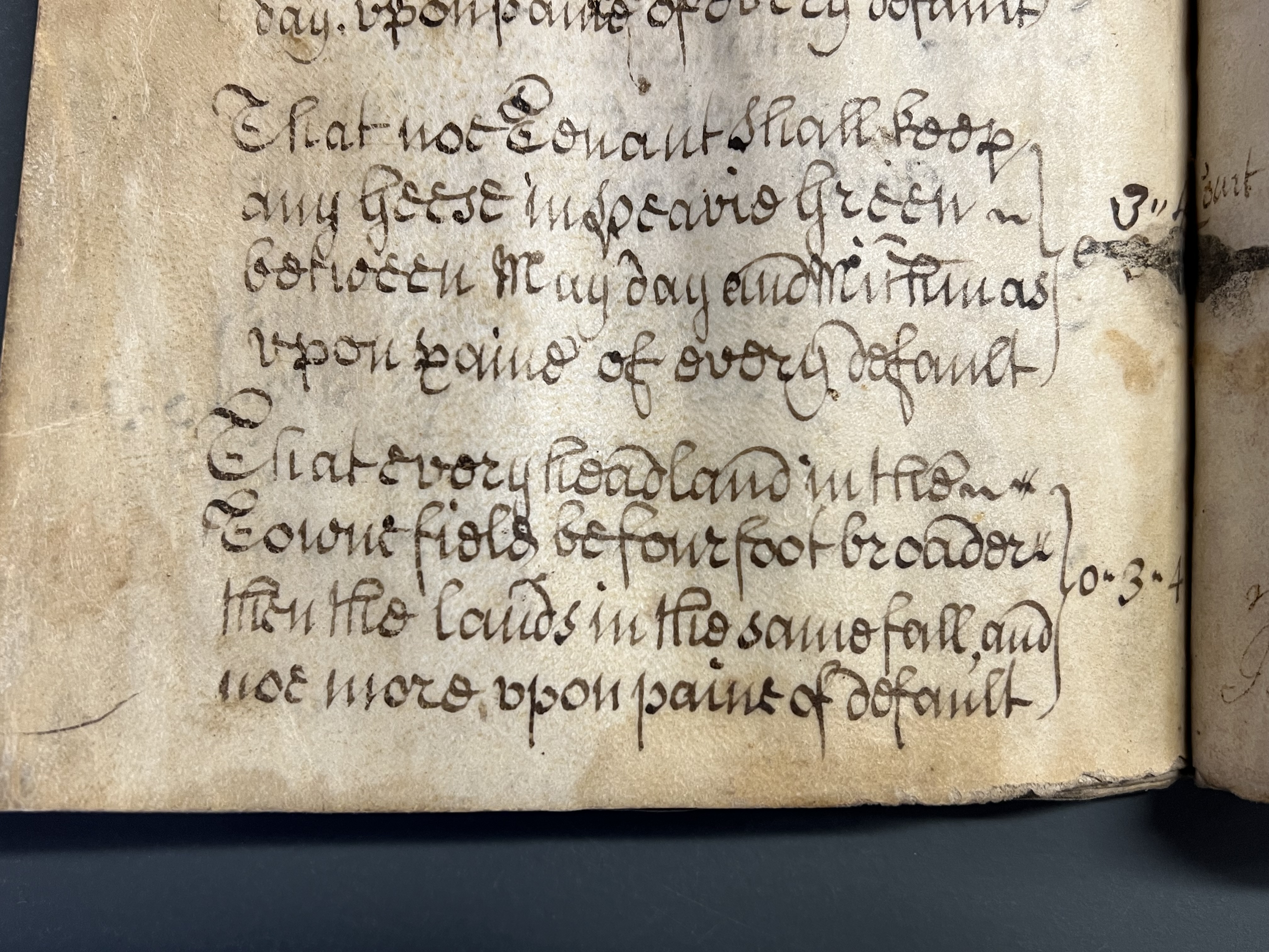
Z.1353 Pains book for the Manor of Harome, signed by the manor court jury, 29 October 1737
These court records also tell us that “none keep any more sheep upon the Common or Commonfields but according to the ancient rent on paine of 3s 4d”. The same fine applies “That every Tenant in Haram doe keep stint in the pasture Ings, and averages on paine of every default” [Z.1353]. The Ings in Harome were a lower-lying area of marshy ground and meadow in the south-east of the township, around 35m above sea level, which would flood seasonally and be used for common grazing on the grass sward and for hay production in summer to provide feed for livestock over the winter months. Further to the east, across the Beck, lay Harome Common, an area of waste land which would also be used for grazing, and collection of whins and gorse for fuel. Villagers would each have been allocated a specified number of animals, or stint, that they were permitted to graze on this common land.
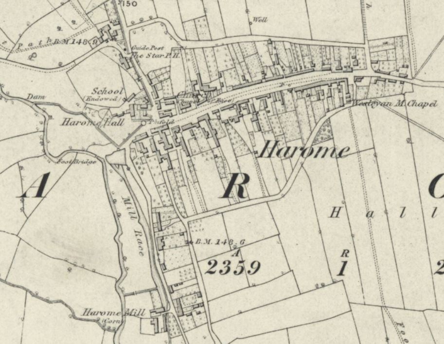
In addition, a pinfold (also known as a pound) for containing stray livestock is shown on the first edition 6-inch to the mile Ordnance Survey map of Harome of 1856 at the north-western end of the main street (NYHER MNY 32499). The pound is also mentioned in the 18th-century Harome manor court pains book, the fine being 3s 4d: “Tenants shall not take their goods out of the common pound without the consent of those who impounded them”.
Enclosure by agreement (prior to 1782)
The major landowner in the late-18th century was Charles Slingsby Duncombe Esquire, who was also Lord of the Manor and Rector of the parish of Helmsley. A plan made for him in 1782 [ZEW(M)8a, see above] also records land owned by His Grace the Duke of Rutland and Lord Downs. Another undated, but probably late-18th century, plan of the township [ZEW(M)17, see below] shows a number of strips of Glebe land belonging to the church distributed amongst various open fields, as well as the ancient Haw Farm, and Hall Garth Farm. These latter two farms, both lying in the western part of the township along the River Rye exhibit an irregular pattern of straight-sided rectilinear fields. Central to the southernmost of the two farms, Haw Farm, was the medieval moated site of the Old Hall. The northernmost, Hall Garth Farm, adjoins the area of the site of the later manor house, Harome Hall, at the western end of the village (NYHER MNY 1350). Originally, the fields of both these farms were most probably demesne lands belonging to the Lord of the Manor and, therefore, outside of the open-field system.
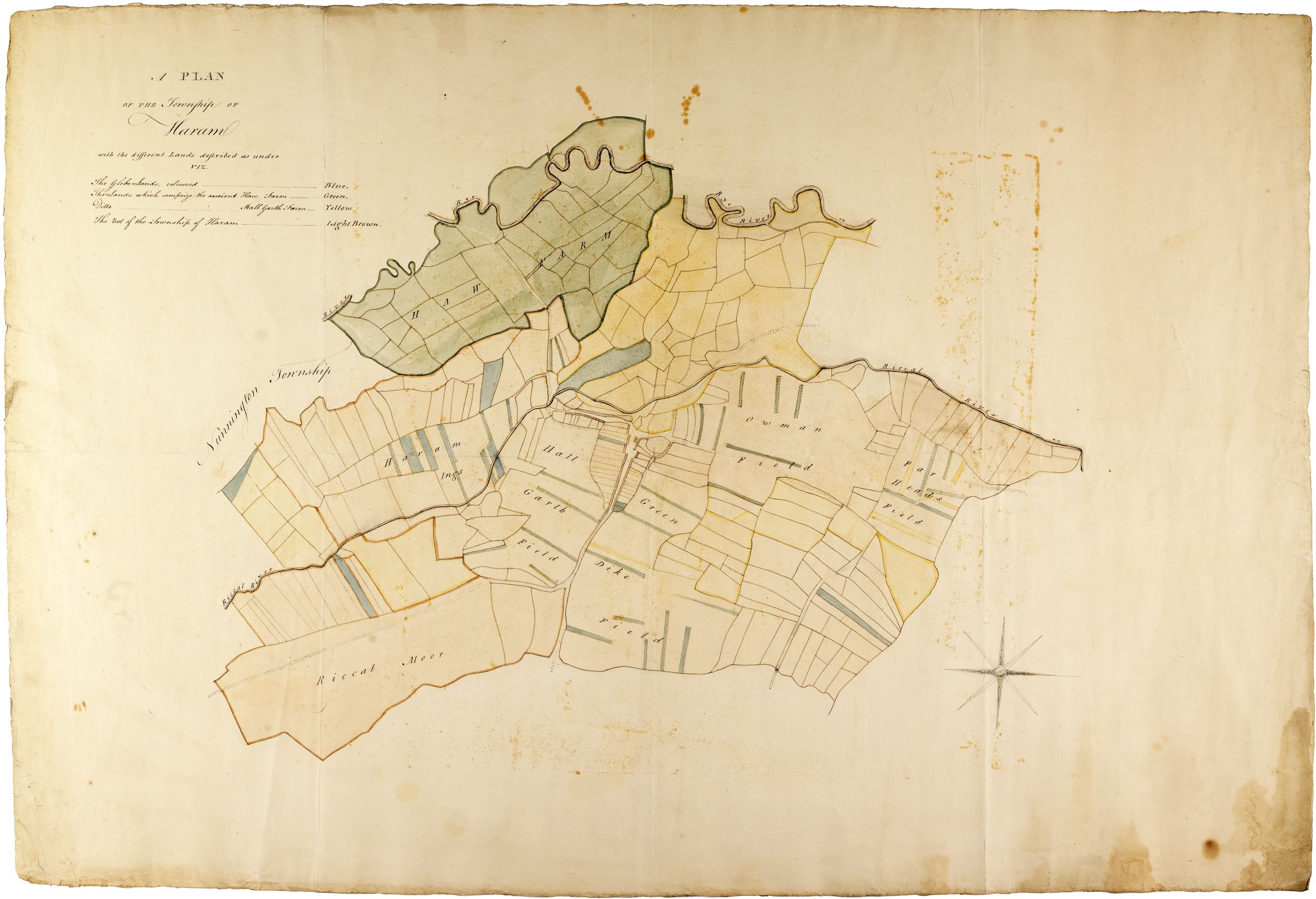
In other parts of the township, both the late-18th-century plans [ZEW(M)8a & ZEW(M)17, see above] show areas of more regular, larger rectilinear fields on similar alignments to the furlongs of the open fields. These suggest that, prior to 1782, there has been gradual and piecemeal enclosure by agreement, whereby some areas of former open fields have been enclosed by combining of a number of strips together. This could have occurred either by a freeholder buying the strips adjoining his, or exchanging lands with others, so that his landholding was consolidated into one particular area rather than being spread over several fields, usually to create enclosed fields for pasture out of the arable areas. That such enclosure had taken place prior to 1816 is also evidenced by the references on the enclosure map of Harome Common [ZEW(M)24], which labels adjacent areas as ‘Old Inclosures in the Township of Harom’, which are also referenced in the Award itself [NRRD I/ZEW].
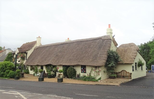
Lake & Edwards (2006, 36) note that following late-18th-century enclosure, the cruck-framed, thatched houses and outbuildings, which characterised villages such as Harome, were largely abandoned as farms grew in size. Some of these early buildings survive today, having formerly been incorporated into farmsteads or converted into accommodation for labourers. Later-17th-century cruck-framed timber structures can be identified by the listed building descriptions of a number of properties in the village, for example The Hollies (NHLE 1315895) and The Star Inn (NHLE 1315892).
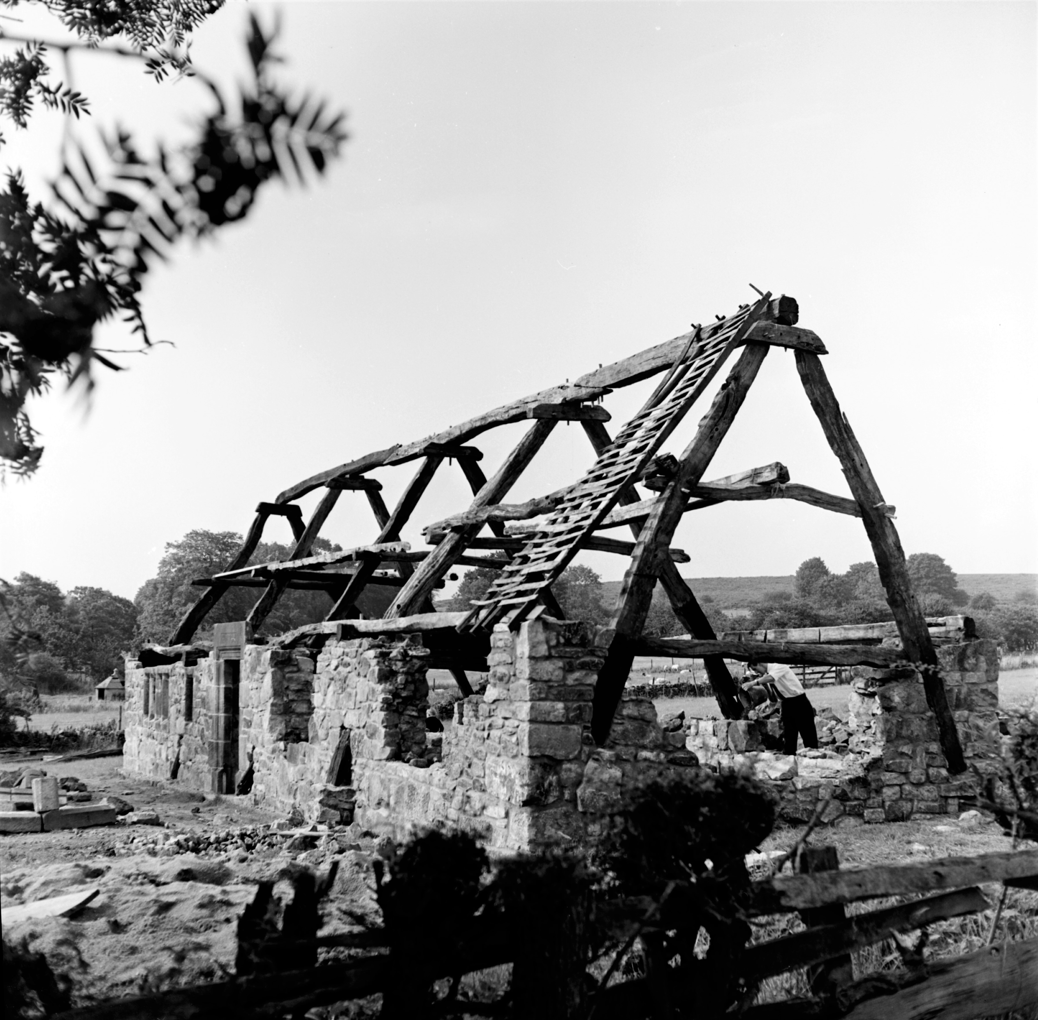
- Left: BU02680A The remains of the cruck frame of Harome Hall being reconstructed in Hutton-le-Hole
- Right: The Star Inn, Harome, 2020 cc-by-sa/2.0 – © JThomas – geograph.org.uk/p/6699355
The 18th-century pains book for the manor of Harome [Z.1353] records fines for numerous offences relating to the management of the land, its boundaries and watercourses. There are many references to the need for the scouring of particular sections of ditch and to keeping the watercourses clear in the areas of the ings and moors. At a time before the 19th-century underdrainage of fields, keeping ditches and watercourses clear was extremely important to ensure that arable land did not become waterlogged and thus affect crop growth. The same manorial records tell us that field boundaries were variously hedges or fences and that tenants should not break these hedges, and fences must be kept in good and sufficient repair.
In an 1801 agricultural return, Murdo (1962, 103) notes that although oats were the main grain crop in Harome, followed by wheat, there was a greater acreage under turnips, which implied ‘improved farmers’ who were planting this crop, which could be used as fodder, instead of having a period of fallow in the rotation (Murdo 1962, 107).
Parliamentary enclosure in the early-19th century
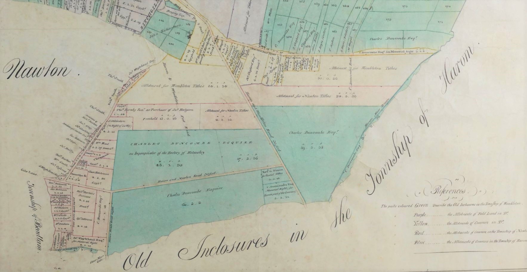
Following an Act of Parliament dated 1806, an ‘Award for the enclosure of open fields and common, including moor or common on Harome Moor, Wombleton Common, Hungerhills etc in the townships of Harome, Nawton and Wombleton’ was made on 15th June 1816 [NRRD 1/ZEW].
This enclosure award describes the division of the lands of Harome Common between the three neighbouring townships of Harome (197 acres), Wombleton (102 acres) and Nawton (103 acres). The accompanying plan shows, in green, the areas allotted to Harome township to the east of Harome Moor Drain, and a triangular area of land in between Harome Moor Drain and the present Common Lane [ZEW(M)24].
There is provision for a new public footpath called the ‘Wombleton and Harom Foot Road’ over the Common to the town of Harom, and a new private occupation carriage road eastward over the Common to a width of thirty feet, excluding the ditches and fences, called ‘Harome Heads Road’. The Enclosure Commissioners also award a public drain to be a width of 3 feet at the bottom, and “of sufficient depth to carry off the water freely called Harom Moor Drain...”
Of the part of the Common apportioned to Harome, 45 acres is allotted to Charles Duncombe Esquire as Impropriator of the Rectory of Helmsley. The Reverend George Dixon and his successors as Vicar of Helmsley are awarded 3 acres and 18 perches in lieu of the vicarial tithes. These tithes, great and small, are calculated “to be equal in value to one eighth part of the residue of that part of the said Common appropriated to the township of Harome after setting out the roads…“ The remaining areas (c.148 acres) are awarded to Charles Duncombe Esquire. All are required to make and maintain a sufficient ditch and fence around their allotted lands [NRRD 1/ZEW]. The introduction of better drainage will have improved the waste land for the cultivation of crops.
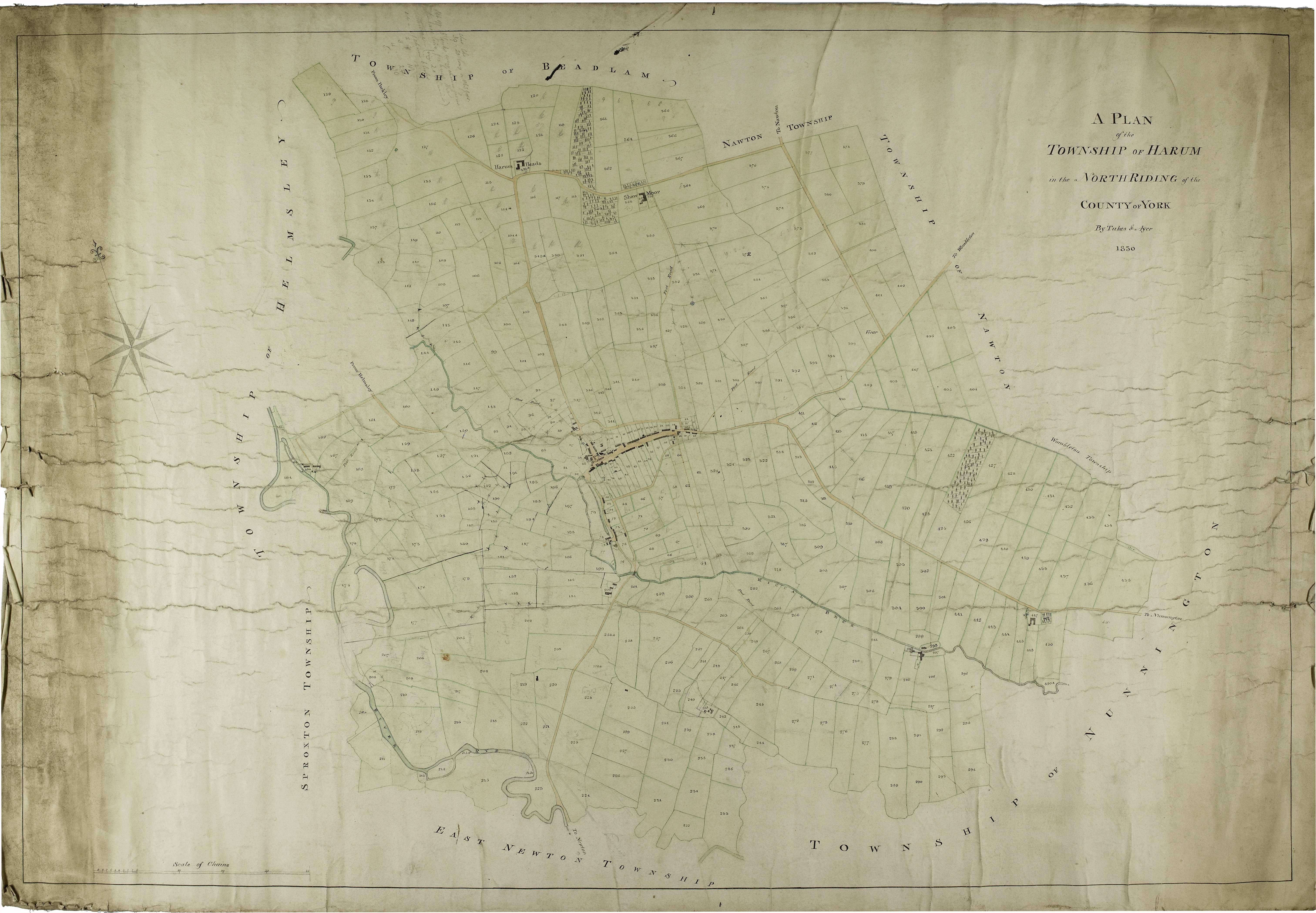
The township of Harome in 1830 and beyond
An 1830 plan of the township of Harome shows the newly-enclosed areas of the Common in the east [ZEW(M)52]. By this date, other areas of the township have also been enclosed, presumably by private agreement; the furlongs of the open fields and their individual strips have gone, and the field pattern has changed to one of larger, rectilinear fields, regularly laid out with straight boundaries. New, isolated farmsteads have been created at some distance from the village to the north (Harum Heads and Shaw Moor, with new woodland plantation in between) and south east, which were not present in 1782 [ZEW(M)8a]. This enabled farmers to be more conveniently located in the middle of their landholdings, closer to livestock and crops. These two northern farms are still subject to tithes, as evidenced by the Tithe apportionment and map of 1848 [T].

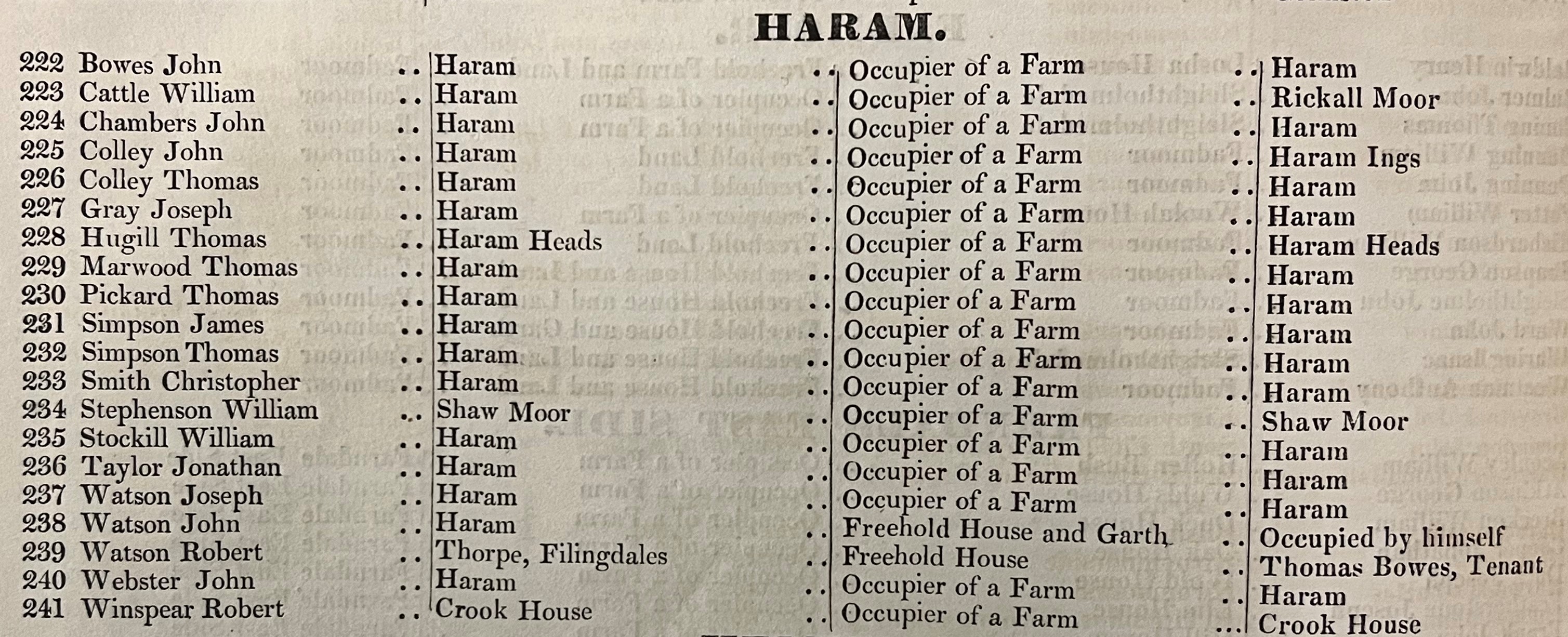
The earliest Register of Electors for the North Riding of 1832 lists eighteen men whose nature of qualification to vote is cited as ‘occupier of a farm’ in Haram [QDE(R)]. Whilst most of these farms are unspecified, Rickall Moor, Haram Ings, Haram Heads, Shaw Moor and Crook House are identified by name.
By the mid-19th century, as seen on the first edition 6-inch to the mile Ordnance Survey map of 1856, the field pattern of the township remains broadly similar (see above and Yorkshire Sheet 89 and Sheet 90). More recently, boundaries have been removed as fields have been combined and further enlarged to accommodate modern farm machinery and practices. Nevertheless, traces of these earlier field systems can still be seen in the modern landscape and evidenced via historic map regression, archive material and archaeological records.
Further information
The National Archives Research Guide on Enclosure Maps & Plans
You can find details of the enclosure maps and awards held in our collections in our searchroom Guide no.4
Copies of many of the historic maps of Harome shown above are available to purchase via our online shop
References
Lake, J. & Edwards, B. Historic Farmsteads: Preliminary Character Statement Yorkshire & The Humber Region English Heritage/Countryside Agency, Gloucester, 2006
Musto, N.M. A study of the settlements to the north of the Vale of Pickering, Volume I, Durham theses, Durham University, 1962
Page, W. (ed) ‘Helmsley Parish’ in A History of the County of York North Riding: Volume 1 London, 1914, pp. 485-505. British History Online
Post Office Directory of the North and East Ridings of Yorkshire with the City of York, London, 1872 – entry for Harome, page 144
