
By Gail Falkingham, Record Assistant
In this blog in our series on garden history, we focus on one particular estate archive and related records within our collection, and what they can tell us about the gardens and designed landscape of the principal country house of the estate, Kiplin Hall.
The Kiplin Hall Archive
The County Record Office holds an extensive archive from Kiplin Hall (ZBL), deposited by Bridget Talbot in 1951. This archive contains material spanning 400 years from 1558 to 1930, over which time four main families made their mark: Calvert, Crowe, Carpenter and Talbot.
The Hall has Jacobean origins and was built around 1620 for George Calvert. It was at its peak as a Victorian garden in the late 19th century, designed for Admiral Walter Carpenter by the architect William Eden Nesfield (1835-1888), elder son of William Andrews Nesfield, the landscape architect and artist. He carried out work to the buildings as well as the gardens. The eastern parkland was most likely fully laid out around 80 years earlier, when the Hall was owned by Robert Crowe.
The Kiplin Hall archive includes title deeds, wills and mortgages, manorial and estate records, legal papers, personal and family papers, parish records as well as maps and plans. These include a wealth of correspondence, hall and garden accounts, vouchers, surveys and valuations, and sale particulars.
Other archive collections, including the North Riding of Yorkshire Quarter Sessions records (QSB) and the ecclesiastical parish records of Bolton on Swale (PR/BOL) also contain relevant information.
Two 18th-Century Plans
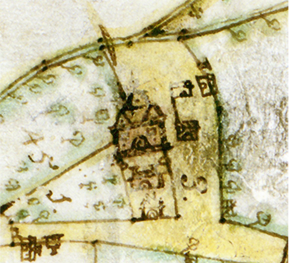
The first detailed map of Kiplin is a 1723 plan of the estate of Christopher Crowe (ZBL M 1). This shows a court to the east front of the house, which appears to be divided by a central building into an inner and outer court, with a gateway out into the land beyond. There are no specific gardens shown, but there are multiple trees depicted in two fields immediately adjacent, which could be orchards. Fields are numbered, but unfortunately no accompanying field book has survived with the map to tell us the field-names and land use.
The surrounding landscape was largely in agricultural use at this time. The rectangular fields to the east of the Hall are enclosed by hedges, and the road from Northallerton to Richmond passes immediately to the east of the house.
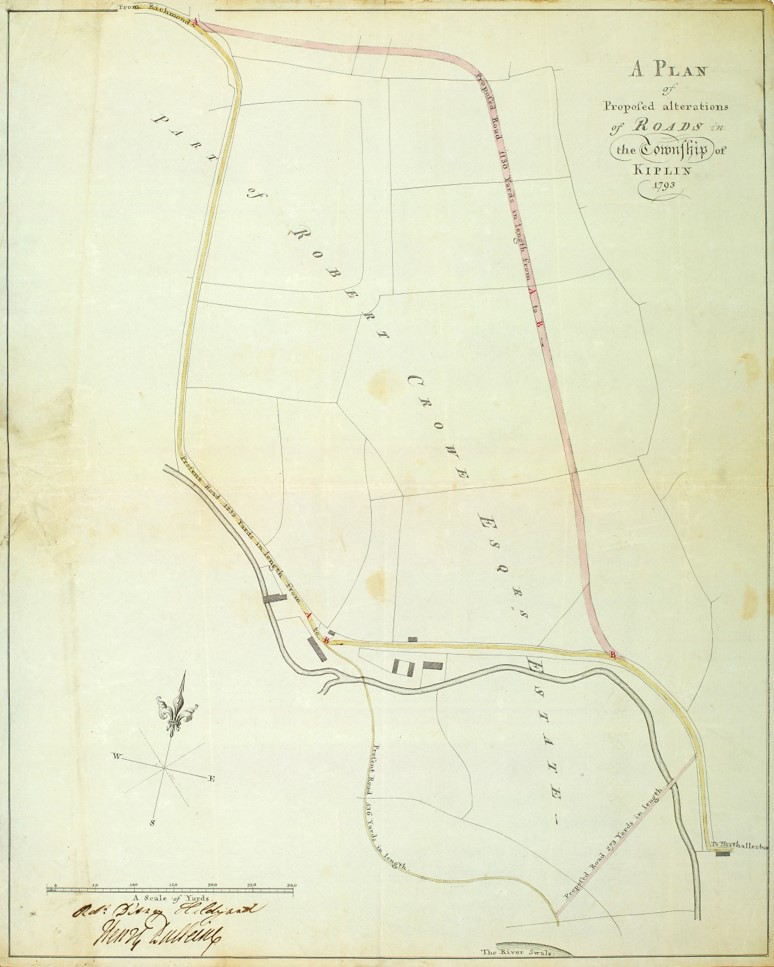
The second plan relates to a 1793 diversion order, which was granted to allow Robert Crowe to move the course of the Northallerton to Richmond road further to the east. The plan comes from the North Riding of Yorkshire Quarter Sessions Records for Easter 1793 (QSB/1793 Q2/13). This would have given Robert Crowe control over a larger area around the Hall, enabling him to extend the area of eastern parkland over existing agricultural land, build the enclosing boundary wall and plant several belts of trees around the perimeter.
Two 19th-Century Survey Books
Estate surveys were undertaken to record the extent and topography of the landholding of particular owners; these usually comprised a plan and an accompanying survey, or field book. Often, only one survives without the other; sometimes both were combined in a single volume. Fields and parcels of land shown on the plan are numbered, and listed in the survey book along with details of the occupier (tenant), field name, land use (such as arable, pasture, meadow, woodland or house and garden), size (measured in acres, roods and perches) and sometimes rental value (in pounds, shillings and pence).
Such surveys were often commissioned for probate purposes after someone had died, or when there was a change in ownership, of land agent/manager, or after new lands had been purchased.
The Kiplin Hall archive includes an undated survey book, c. 1800-1830 (ZBL IV 5/13). At the end, is a summary of the contents entitled ‘A Summary of Robert Crowe’s Esqr Estate’. Therefore, it is likely to have been produced during the period of Robert Crowe’s ownership of the estate, or shortly after his death (he inherited in 1782 and died in 1818). This survey lists the various farms within the estate and the size of all the fields. The record for ‘Kiplin Unlet’ (presumably the home farm) makes the first mention of the different areas of the gardens at Kiplin. Unfortunately, there is no accompanying map to locate these areas. They are listed as:
- A Bowling Green
- Inner Garden
- Flower Garden
- Out Garden
- Pleasure Ground with Long Garden
- Drying yard and nursery
- Rookery
- High Walk, James Walk and Walk North of Hugh Close

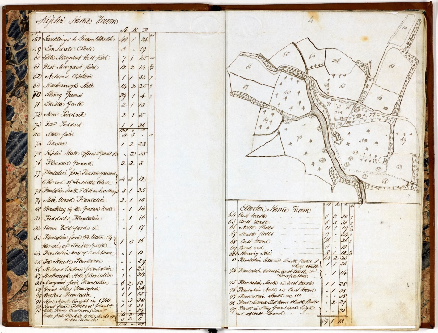
A second survey book can be found within the Bolton on Swale parish record collection (PR/BOL 4/2). This is also undated, but thought to date to around 1840 as it is very similar in style to the tithe map of the township of Kiplin of 1839 (T – see below). It contains a mention of the Earl of Tyrconnel, so is likely to post-date 1818, when John Delaval Carpenter, 4th Earl of Tyrconnel and his wife Sarah inherited the estate from Sarah’s father Robert Crowe. Like the earlier example, for a number of farms within the Kiplin Estate, this survey book contains lists of all the field names with details of their acreages. This one is different, however, as it also contains sketch plans of each farm, which help us to locate specific features (see below).
Listed at Kiplin Home Farm are:
- Garden (referring to the walled kitchen garden)
- Pleasure Ground
- Shrubbery by the garden wall
- Levellings to Gravel Walk (part of the area of the eastern parkland)
- Thistle Garth
- Several plantations of different names, including Ice House Plantation, Great Plum Tree Moor Plantation, and Plantation west of Coach Road.
- Stoney Greens (part of the area of the western parkland)
- Near Paddock (now the orchard)
- Far Paddock (now known as Lady Tyrconnel’s Garden)
Two 19th-Century Maps
The 1839 tithe map (T) shows details of the gardens and plantations at Kiplin Hall, although its purpose was primarily to work out the monetary payments owed in lieu of tithes being paid in kind following the 1836 Tithe Commutation Act. It did not aim to record the landscape to the level of detail that the first edition Ordnance Survey maps would some 20 years or so later.
The parkland to the east of the hall is shown very clearly, as is the Peninsula wood (shaped like a Christmas stocking). There is woodland to the west, two ponds, a serpentine fish pond created from the Kiplin Beck, with a pastoral landscape and the Gothic Barn beyond. The accompanying tithe apportionment listing includes: shrubbery, garden, pleasure ground with two ponds, far paddock and near paddock, plantations and levellings to gravel walk, similar to the survey book previously mentioned above (PR/BOL 4/2).

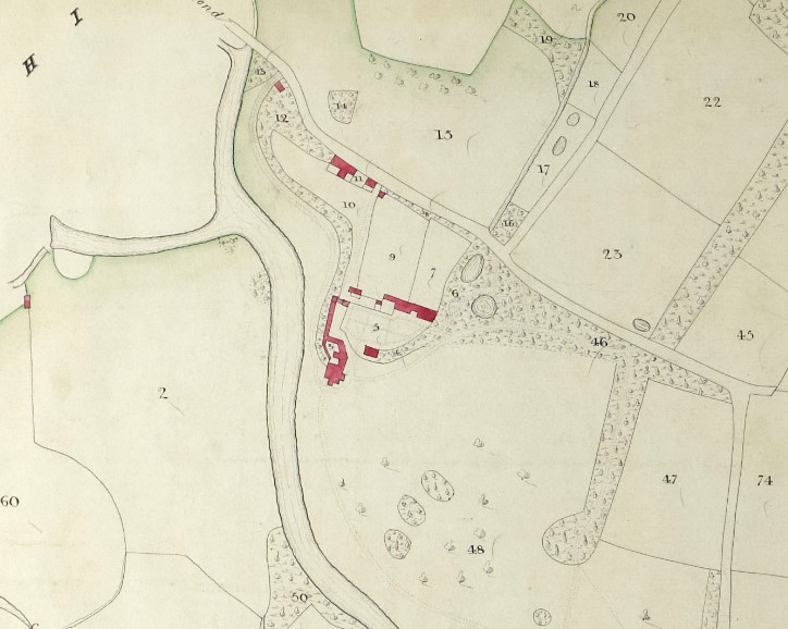
The first edition, 6 inch to the mile Ordnance Survey map which covers Kiplin (sheet 55, surveyed 1854) was published in 1857. This, and particularly the later, 25 inch to the mile first edition map (sheet LV.NW, surveyed 1891), published in 1893, show greater detail, including a summer house marked in the Peninsula wood, orchards planted in one of the paddocks, the arrangement of the walled garden and Lady Tyrconnel’s garden to the north of the Hall.
19th-Century Correspondence
Between 1867 and 1887, Walter Cecil Carpenter, also known as Admiral Carpenter, made improvements to the Hall and outbuildings at Kiplin. He engaged the architect William Eden Nesfield to construct a new stable wing, install the clock tower and to raise the roof over the south wing to create a second storey. He also carried out work on the gardens.
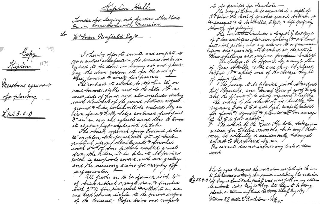
The Kiplin Hall archive includes a copy of Joseph Meston’s agreement for planting, as part of the tender for laying out the gardens, for the sum of £423, dated 23 May 1879 (ZBL IV 6/6).
The archive also contains a large collection of over 1800 letters (ZBL IV). These were transcribed by a dedicated team of volunteers working as part of the Charting Chipeling Project. There is a wealth of correspondence within this collection between William Eden Nesfield and Walter Carpenter. Also featured are Joseph Meston, who was overseeing landscaping works and William Dimes of Sunderland, who was carrying out the planting.
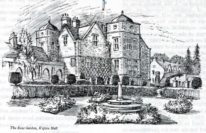
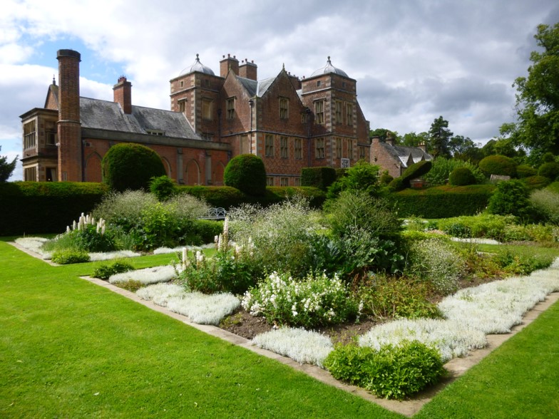
These letters refer to the creation of a new drive from the front door of the Hall through the parkland to the east in 1878. The lime avenue planted before 1891 can still be seen today. A terraced, sunken lawn was made to south of hall for croquet and tennis. Holly and yew hedges were planted, shaped into fine topiary, which also survive today as well as 300 roses. The walled garden had well-defined paths, a cutting garden for flowers and a productive vegetable garden to the east.
However, it wasn’t all plain sailing as the letters show. In November 1879, Admiral Carpenter didn’t like his 13ft high garden walls, and reduced them in height to 9ft. In February 1880, many of the rose and holly plants had died after a harsh winter. The correspondence provides a fascinating insight into the relationship between the client, the architect, tradesmen and the suppliers. They faced issues with delays, bad weather, haggling over costs and chasing up snagging lists, just like we do today.
Kiplin Hall is managed by the Kiplin Hall Trust and is open to the public for the house, gardens and designed landscape to be enjoyed by all (please see their website for details). Further details of the history and development of the gardens can be found in their Garden Museum in the bothy behind the walled garden.
Further Reading
‘The Kiplin Hall Archive’ by Hugh Jaques, 1977, in NYCRO Journal 5 (NYCROP 13)
‘The Designed Landscape at Kiplin Hall’ by Val Hepworth, 1995, in NYCRO Review 1995
‘Charting Chipeling: The Archaeology of the Kiplin Estate’, by James Brightman et al, 2017, Solstice Heritage
An overview of the Kiplin Hall archive (NYCRO ZBL) is available via our online catalogue and a detailed listing of the collection is available for consultation in our public searchroom.
Digital copies of historic maps of Kiplin are available for sale in our online shop
