
Whitby and the Frozen North
Whitby ships have a long history of voyaging north and westwards to the Arctic regions. The main reason for this was the whaling trade, and whalers in search of catches could voyage right to the edge of mapped regions and sometimes beyond. Between 1806 and 1827 the record for ‘Furthest North’, the most northerly point known to have been reached by humans, was held by the Whitby whaler Resolution, captained by William Scoresby Sr, with his son as first mate.

Whitby Whalers by George Chambers. Whitby Museum via Wikimedia Commons. Public domain
However some of those who voyaged from Whitby had exploration in mind, and took part in searches for the North West passage. This was a hoped for route to China which it was thought might lie north of the American continent. Such a route does exist but was usually blocked by ice in the period before modern climate warming. James Cook and Thomas Blanky both took part in attempts to find the passage. William Scoresby did not search for it himself, but he did support and encourage attempts to find it.
Whitby and Whaling
In the later eighteenth and earlier nineteenth centuries many ships voyaged from Whitby to catch whales, whale oil having many domestic uses. There were two main whaling grounds, the Greenland grounds east of Greenland, and the Davis Strait grounds west of Greenland which included the south part of Baffin Bay. William’s Scoresby Jr’s book An Account of the Arctic Regions and Northern Whale Fishery was the first detailed account of the British whaling industry and remains a key text.

View of part of the coast of Greenland by William Scoresby from Journal of a Voyage to the Northern Whale Fishery
There are few surviving British whaling journals or logbooks from before 1800 and Thomas Atkinson’s 1774 journal is the earliest known account of a British whaling voyage to the Davis Strait. The voyage, which began on 27th February and ended on 6th August, was the first time the Hope had sailed to the Davis Strait, as at this time British whalers usually preferred the shorter voyage to the Greenland grounds.
Whaling voyages were high risk, and many ships were lost at sea. However the Volunteer, built at Whitby in 1756, had an exceptionally long career. She made whaling voyages from Whitby between 1772 and 1825 and went on to make later whaling voyages from Hull. Her last known voyage, to Sierra Leon, was in 1841.

Map of whaling grounds adapted from William Scoresby, 1823
Further Reading:
More about Whitby and whaling can be found on the Whitby Museum website
Navigation, Science and Magnetism
Navigation was important enough to sailors that it was taught as a branch of mathematics in Whitby schools. Accurate navigation needed detailed maps of coastline areas and accurate survey work was highly valued by both the Royal Navy and merchant captains. Survey maps were produced by complicated calculations of latitude and longitude, and mapping coastlines was a highly skilled task.
James Cook and William Scoresby were excellent surveyors and both charted a good deal of coastline in the Arctic regions. Cook charted large stretches of the coasts of Newfoundland and later of Alaska. Scoresby charted much of eastern Greenland. While Cook carried out survey work on behalf of the Royal Navy, Scoresby’s surveying was voluntary as the main purpose of his voyages was whaling. Nonetheless his work was carried out to a high standard.
Study of the Earth’s magnetic fields was also closely linked to navigation and exploration. Ships relied on magnetic compasses to navigate, but Magnetic North, which compass needles point towards, is not the same as True North and also does not remain consistent as the Magnetic North Pole is mobile. This made navigating in Arctic regions particularly difficult, and also made the Arctic a major area of magnetic study. William Scoresby was a keen magnetic scientist, and many of his published papers are on the study of magnetism.
A significant step in the study of magnetism was the location of the Magnetic North Pole in the Canadian Arctic in 1831. Thomas Blanky was second in command of a five man party which spent a full day at the Pole making observations. Although the Magnetic North Pole is no longer in the same place this was a major scientific achievement.

This Mariner’s Compass has 32 points, some compass designs have 64 points [ZW IX 3-5]
Elements of Navigation: Pages from a Whitby maths book
If you were learning maths in Whitby in the eighteenth or nineteenth century you would be expected to learn navigation. Navigation means finding how to get from where you are to where you want to be. At sea there are no landmarks to guide you so special methods need to be used.
Today we have GPS satellite navigation, and can learn where we are and where to go from a few simple touches on a screen. Before GPS navigation was much more complicated and was a difficult skill to learn. However it was essential for ships making long voyages and successful sea captains needed to know how to navigate
Our archive holdings include a handwritten Whitby school text book, believed to be eighteenth century, which contains a number of sample navigation problems. Some pages from the book are reproduced here:


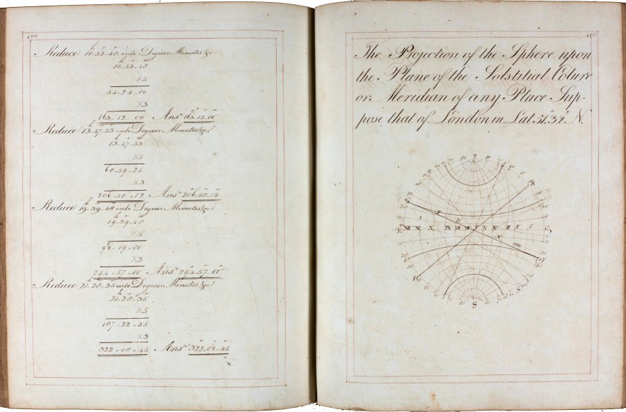


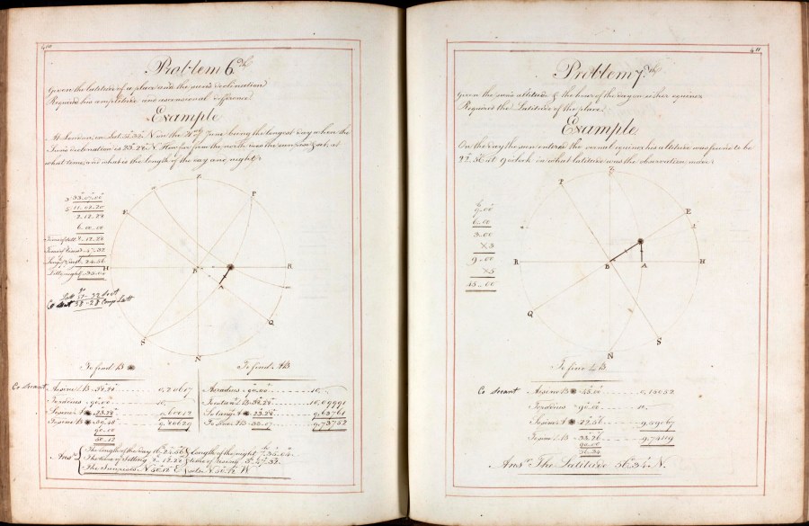


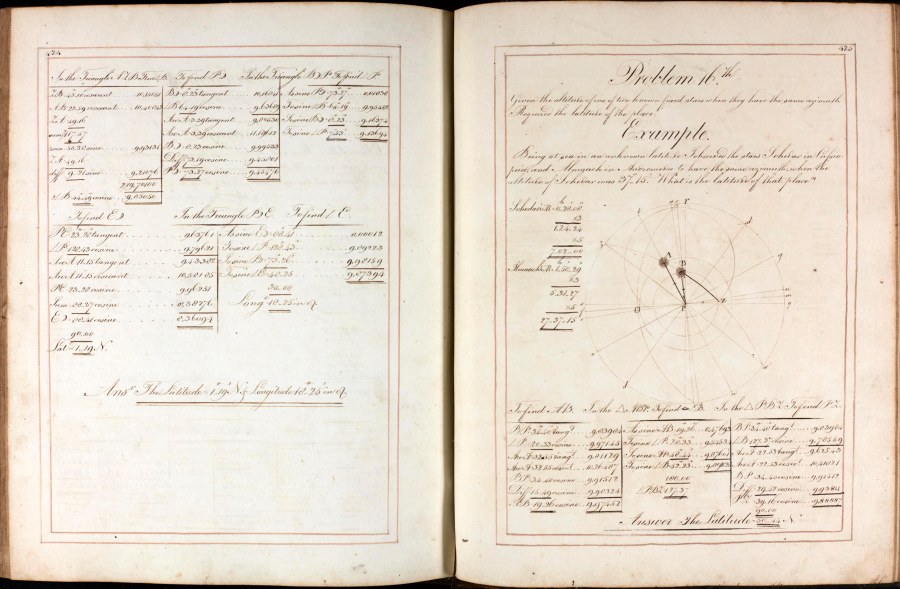


Elements of Navigation [NYCRO ZW IX 3-5]
Explorers in the Archives
While records of exploring voyages are often held in national archives, local record offices can hold a good deal of information about the shore lives of explorers and other mariners.
Famous men like James Cook have been researched in great detail. Parish registers and other local records still offer opportunities for research into the lives of humbler seafarers like Thomas Blanky and Thomas Atkinson, whose journal was discovered and deposited quite recently.
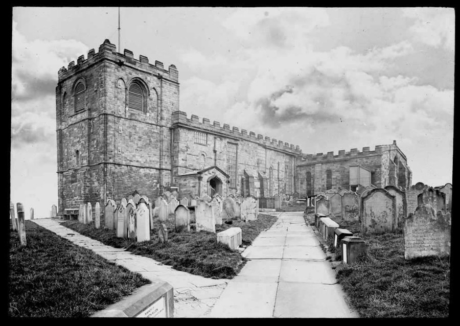
St Mary’s Church, Whitby photographed by George Washington Wilson [EF451-038B] (this image is available from our online shop)
Thomas Blanky’s signature on the Whitby marriage lines of Anthony Buck, one of his shipmates on the 1829 Ross Expedition, shows how friendships among Arctic survivors could endure after they had returned to their home ports. It also made it possible to trace Buck’s later life. Unlike Blanky, he was not tempted to return to the Arctic; his burial in St. Mary’s churchyard, Whitby is recorded in 1860.

Burial record of Anthony Buck [PR-WH 1-50]
Further Reading:
Our holdings of parish registers can be consulted on the subscription websites Ancestry and Find my Past which can be accessed at most North Yorkshire Libraries.
