
Treasures from the Parish Chest: exploring North Yorkshire’s church history from archives to architecture
A number of sources of income and revenue helped to support the parish church and priest. These included the income from the glebe land of the parish, the receipt of small tithes, traditional Easter offerings to the vicar, rents from pews, and charges for services, such as burial.
Glebe
The glebe is an area of land within the parish, used to support the parish priest. The priest could retain the glebe for his own use, or let it out to tenant(s) and keep any income derived from this. Parish and other records may contain details of such glebe land, as shown in the examples below relating to the parish of Masham.


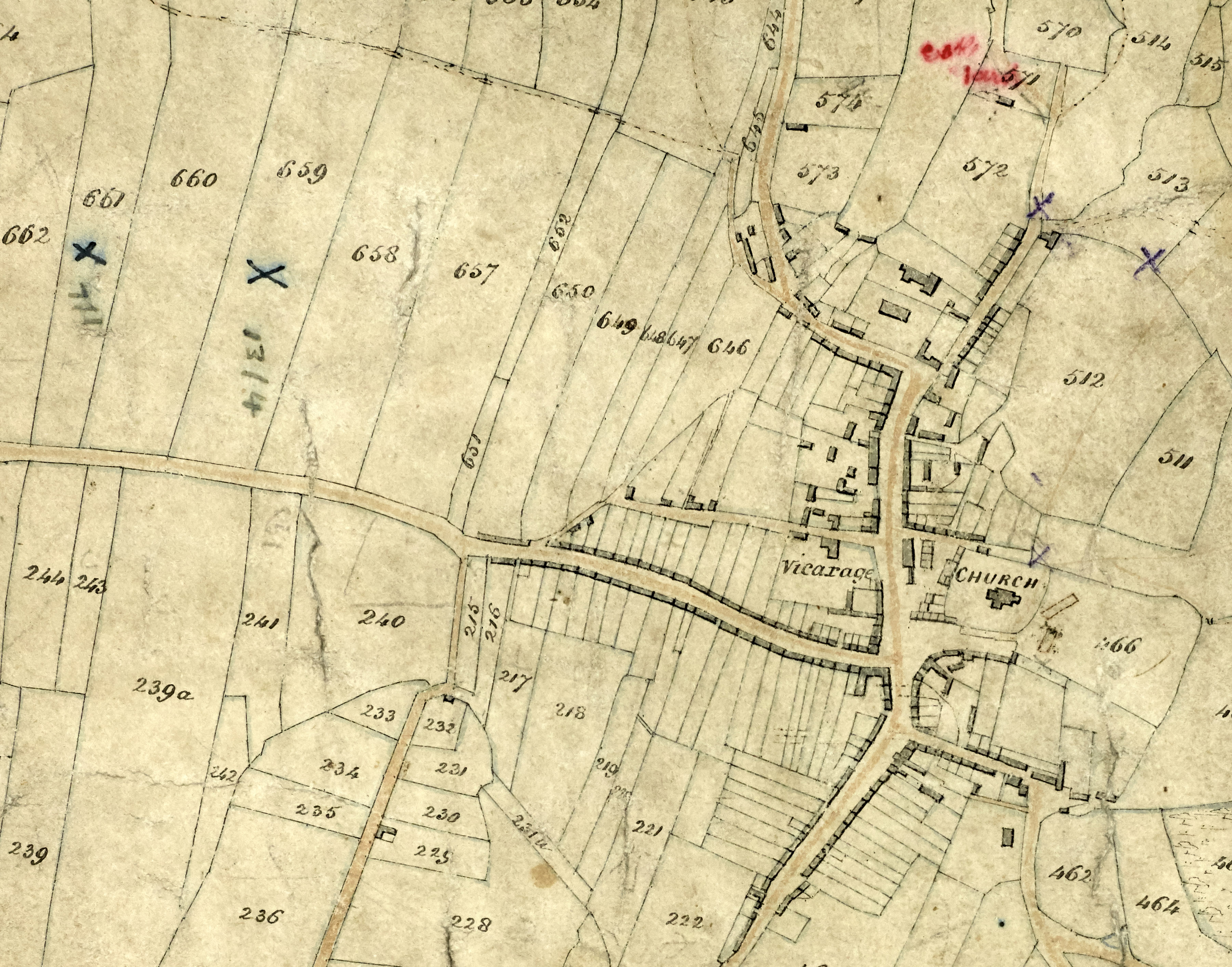
Plan showing the glebe lands of Masham, with detail showing close-up of Masham town, entitled: ‘An actual survey of the glebe lands, and copyhold houses and lands; parcel of the prebend of Masham … lying dispersed amongst the sundry lands of Mr Danby and others, within the townships of Masham aforesaid, in which survey the exact situation of the lands is laid down, together with the roads to the same: taken in 1778 by order of the Master and Fellows of Trinity College, Cambridge and under the direction of Mr Barnard of Leeds by J. Teal his surveyor’ [M27]


A report by members of the Four and Twenty of Masham relating to Masham church land at Sutton Penn Farm, Masham, with related location plan,1895 [PR/MAS 7/14]
The above plans visually record areas of glebe, showing the extent of land in colour and in relation to neighbouring fields and property. As can be seen in the plan of 1778 above [M27], the dispersed distribution of glebe lands across a parish often suggests the way in which the former medieval open fields of a settlement were arranged. Before enclosure, the priest, like other members of the community, would have had a quantity of separate strips of land scattered throughout the open fields, in which the crops grown in each field each year would follow the communal cycle of rotation.
Written descriptions of the extent and location of glebe land can also be found in glebe terriers (see below).
Terriers and inventories
Terriers, or glebe terriers, are written surveys or inventories of glebe land and other property of the parish. The examples below include such property as the church and churchyard, vicarage house, a barn, and a garden, as well as a description of the tithes they are entitled to collect. The 18th century terries for Kirkby Fleetham, Masham and Kirby Sigston are written on pages within churchwardens’ and parish account books. By the 19th century, as in the examples from Thirsk, they are separate documents and ultimately, by the end of the 19th century are written into a pre-printed pro forma terrier and inventory document.
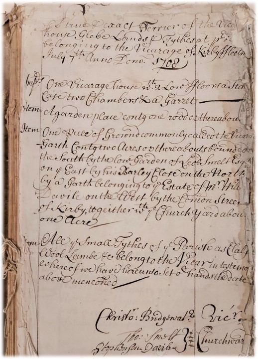

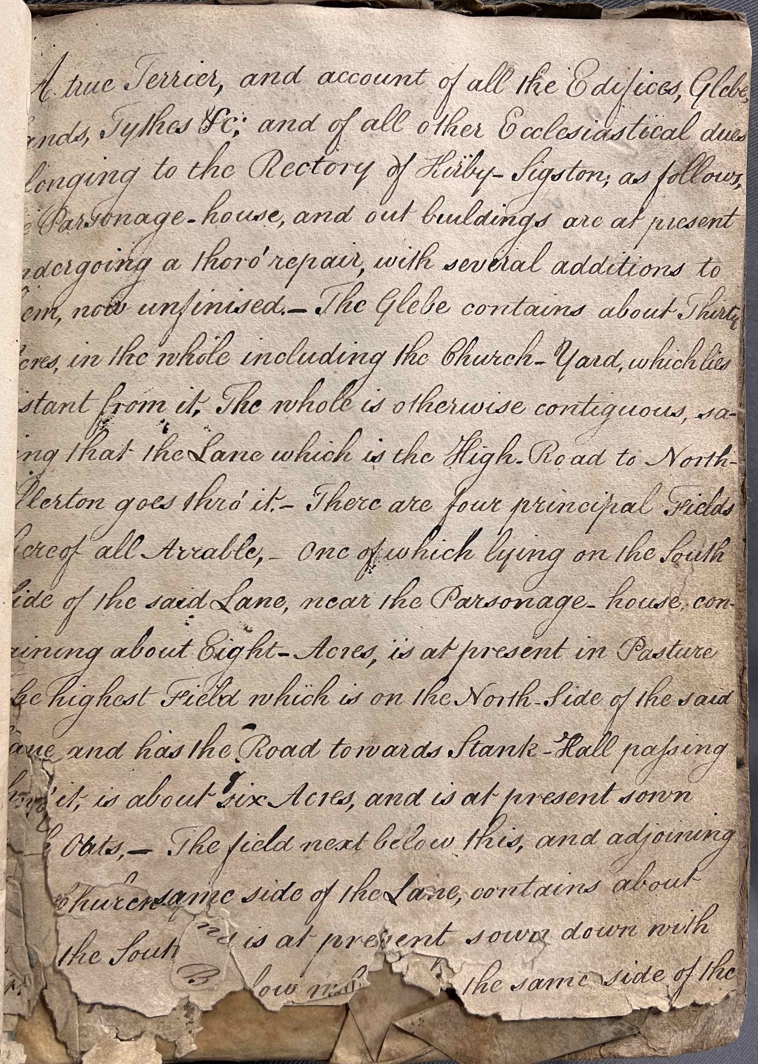

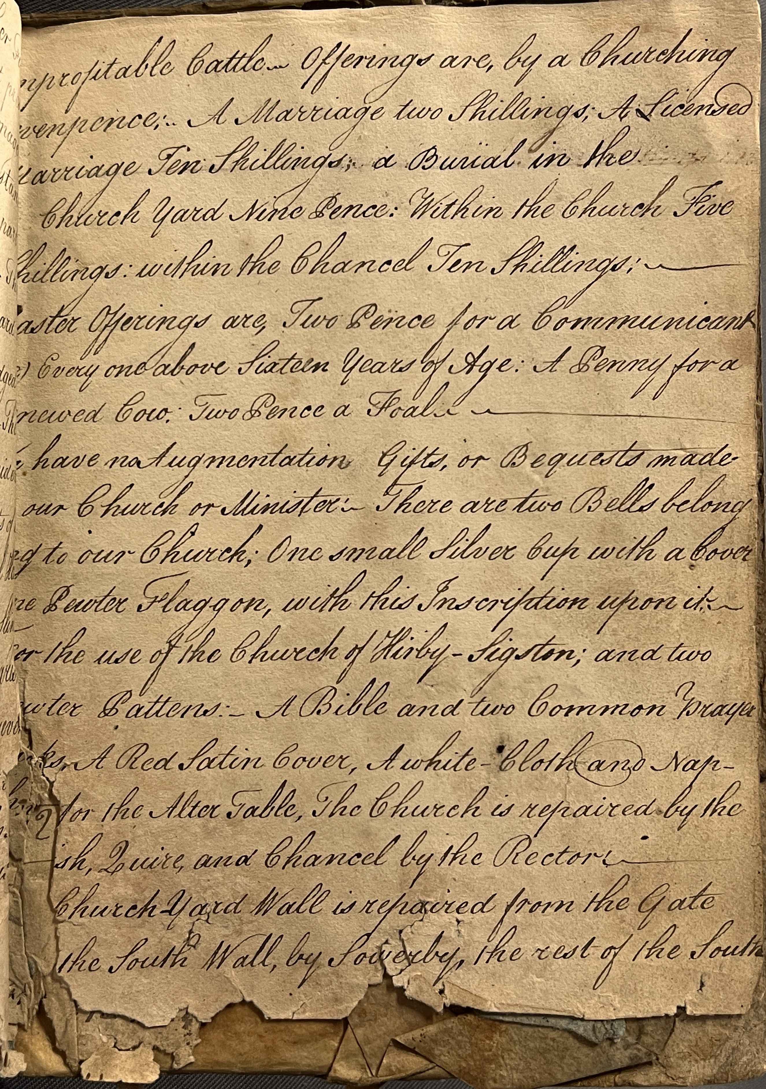

‘A True terrier and account of all the edifices, glebe lands, tythes &c, and of all other ecclesiastical dues belonging to the rectory of Kirby Sigston’, written over four pages at the back of Kirby Sigston, St Lawrence: churchwardens’ account book, 1779-1869 [PR/KRS 4/1]
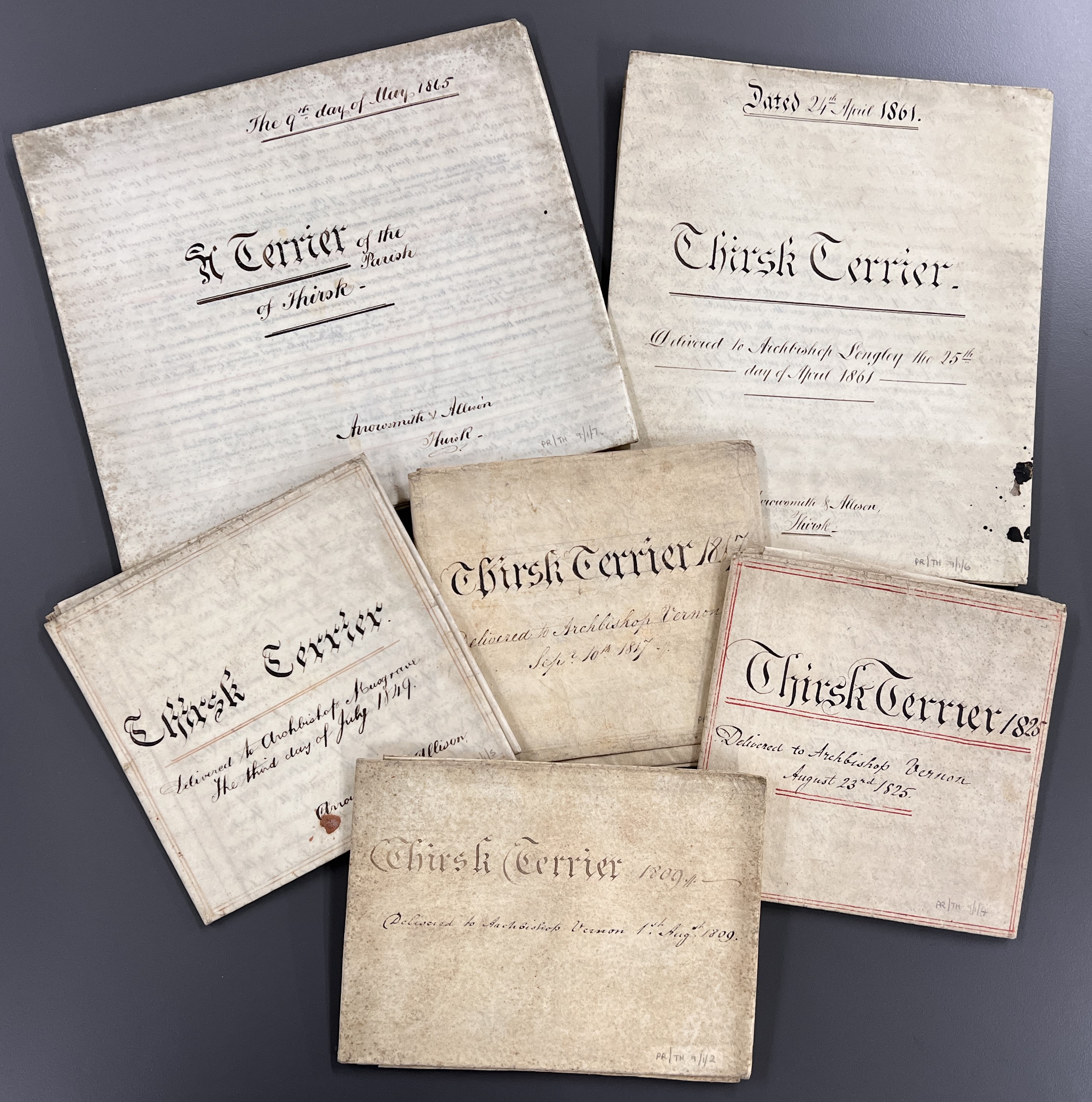

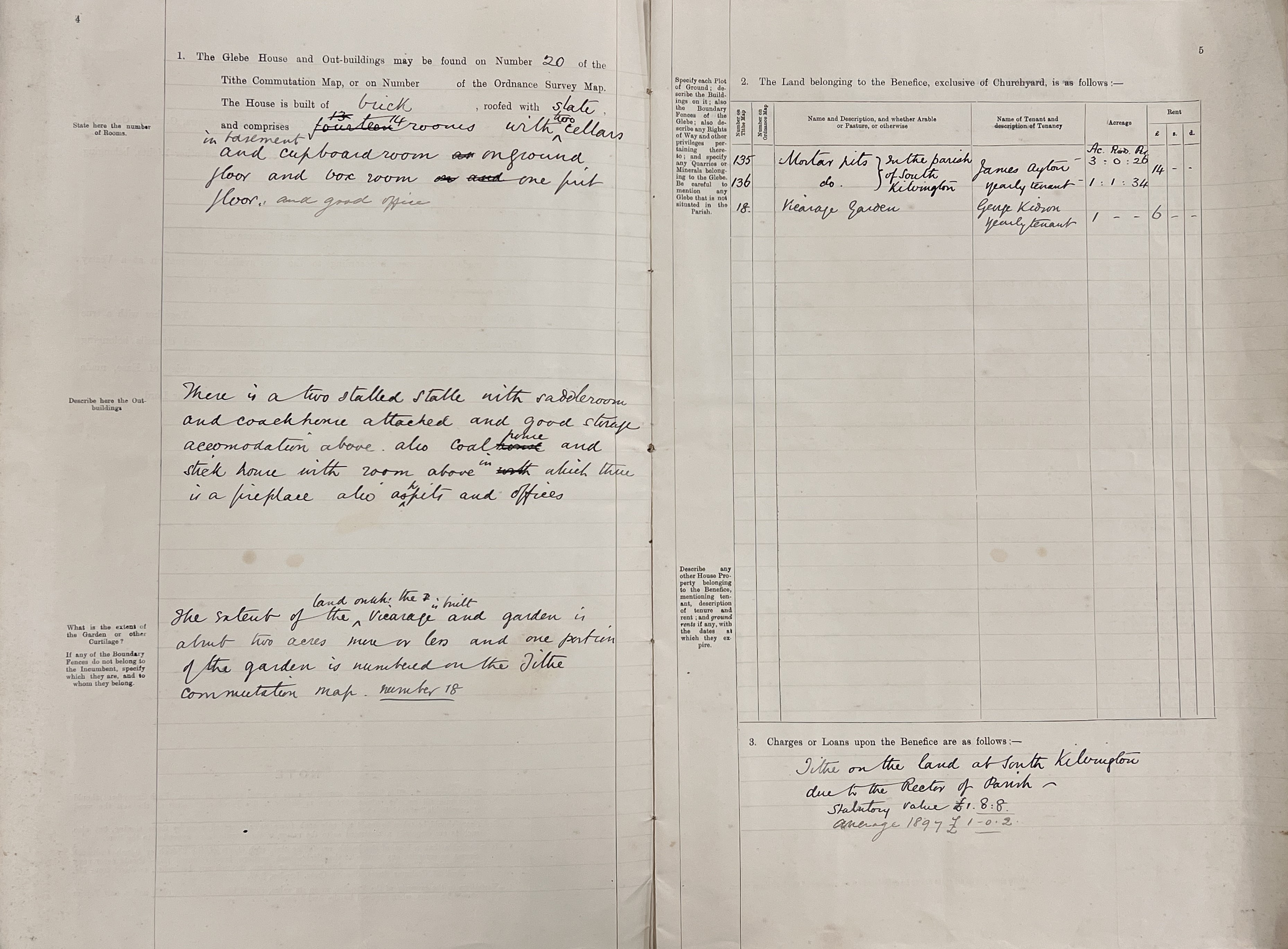
Examples of 19th century terriers and inventories from Thirsk, St Mary from 1809 to 1897 [PR/TH 9/1/2-7 and PR/TH 9/1/8]
Tithes, tithe maps and apportionments
The parish church and its clergy were supported by the payment of tithes. Tithes were a compulsory tax of one tenth on the whole of the produce of the parish, which provided the main source of income for the church. Originally, these payments were made in kind and stored in parish tithe barns.
Great, or rectorial, tithes were usually paid to the rector, who was responsible for the chancel and the rectory. They generally comprised of produce grown on the land, such as corn, grain, hay and wood. The rector could be a lay person, who also acquired the right to nominate vicars, subject to the bishop’s approval. Small, or vicarial, tithes were paid to the vicar, and included animal produce nourished by the land, such as calves, geese, lambs, eggs, wool and milk.


Hampsthwaite, St Thomas a Becket: parish book, 1709-1776 with ‘geese notes’ [PR/HMP 4/2]
These late-17th century ‘geese notes’ appear to be records of the payment of ‘small’ tithes to the vicar of Hampsthwaite and their survival is unusual [PR/HMP 4/2]. The pages give the names of those paying the tithes, the goods on which tithes were raised, mainly numbers of geese and lambs, and their value in £ s d. pounds, shillings and pence. Other pages appear to record payments of the traditional Easter offerings to the vicar, two old pence for every parishioner over the age of sixteen.
By the 19th century, a unified system was introduced throughout the country via the 1836 Tithe Commutation Act. All in-kind parish tithes were converted into a single, annual monetary payment or ‘rent-charge’ linked to the price of grain, subdivided between property owners according to the property’s valuation. In the decade or so after 1836, a survey of the whole of England and Wales was undertaken to establish the boundaries of each parish, and assess land on which tithes were payable. This resulted in the production of tithe maps with an associated reference book, known as the apportionment, identifying each plot of land and the amount of tithe due. The tithe apportionment was originally bound together with the tithe map. Tithes were virtually abolished in 1936.
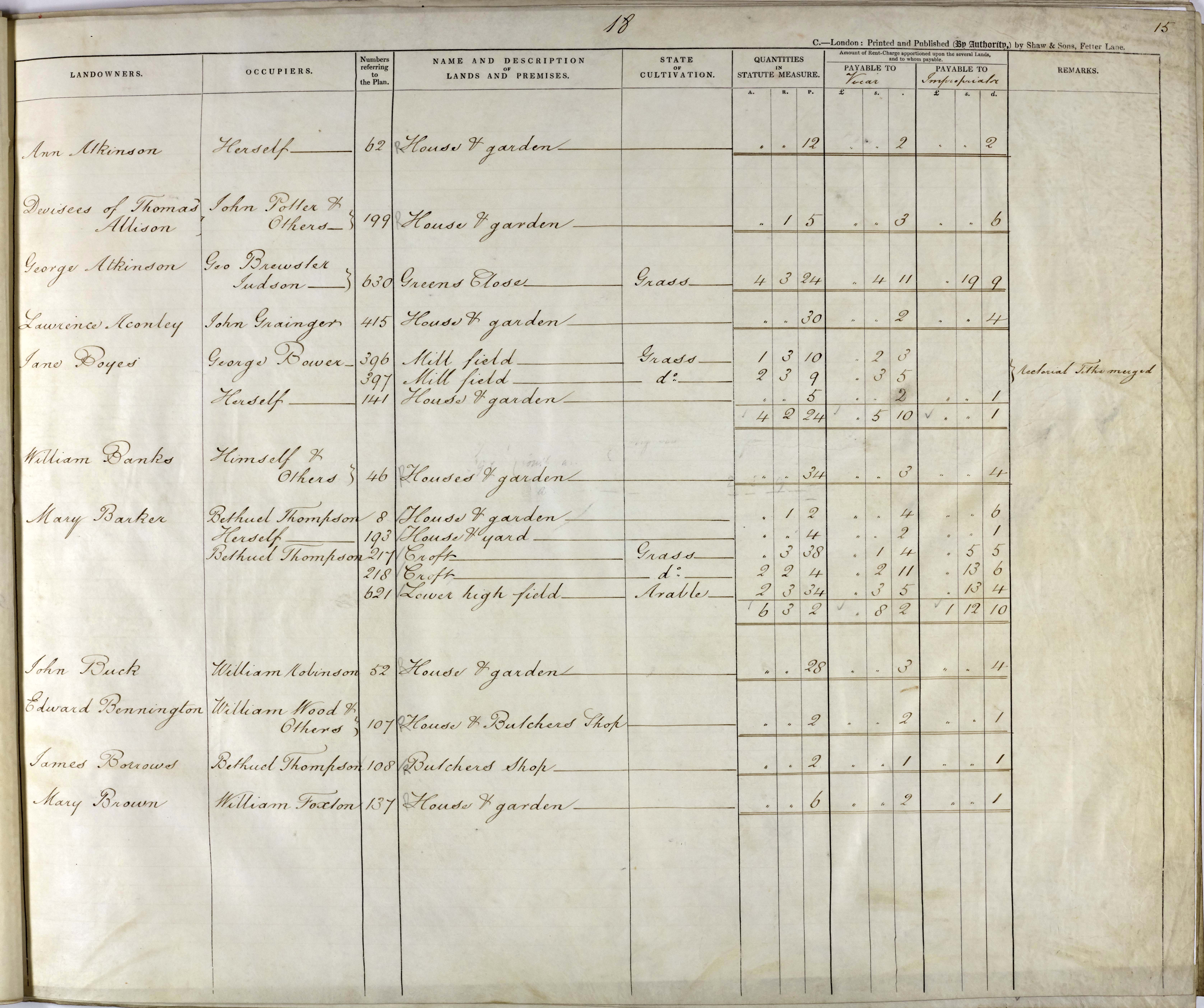
Extracts from Kirkbymoorside tithe map showing the church and vicarage and associated apportionment, recording the amount of tithe rent-charge payable to the vicar and impropriator of tithes, 1848 [T]
In many cases, tithe maps are the earliest complete plan of a parish, as they pre-date the first edition six inch to the mile Ordnance Survey maps, and estate maps and enclosure maps may not map an entire parish. After a map and apportionment had been ratified by the Tithe Commissioners and displayed in the parish, two further copies would be made, one for the diocesan registry and one for the incumbent of the parish. The County Record Office holds over 300 tithe maps for parishes and townships throughout North Yorkshire, but they do not exist for all areas. The National Archives holds a complete set of the Tithe Commissioners’ maps. Neighbouring archives also hold collections of parish and diocesan copies.
You can find out which tithe maps are held at the Record Office via our searchroom Guide no.3, and read more about tithe maps and apportionments in some of our blog posts. We have a guest post by members of the Thornton le Street History Group, about their ‘Roads to the Past’ tithe project and a post about our ongoing County Record Office volunteer tithe project. See also The National Archives Research Guide on Tithes.

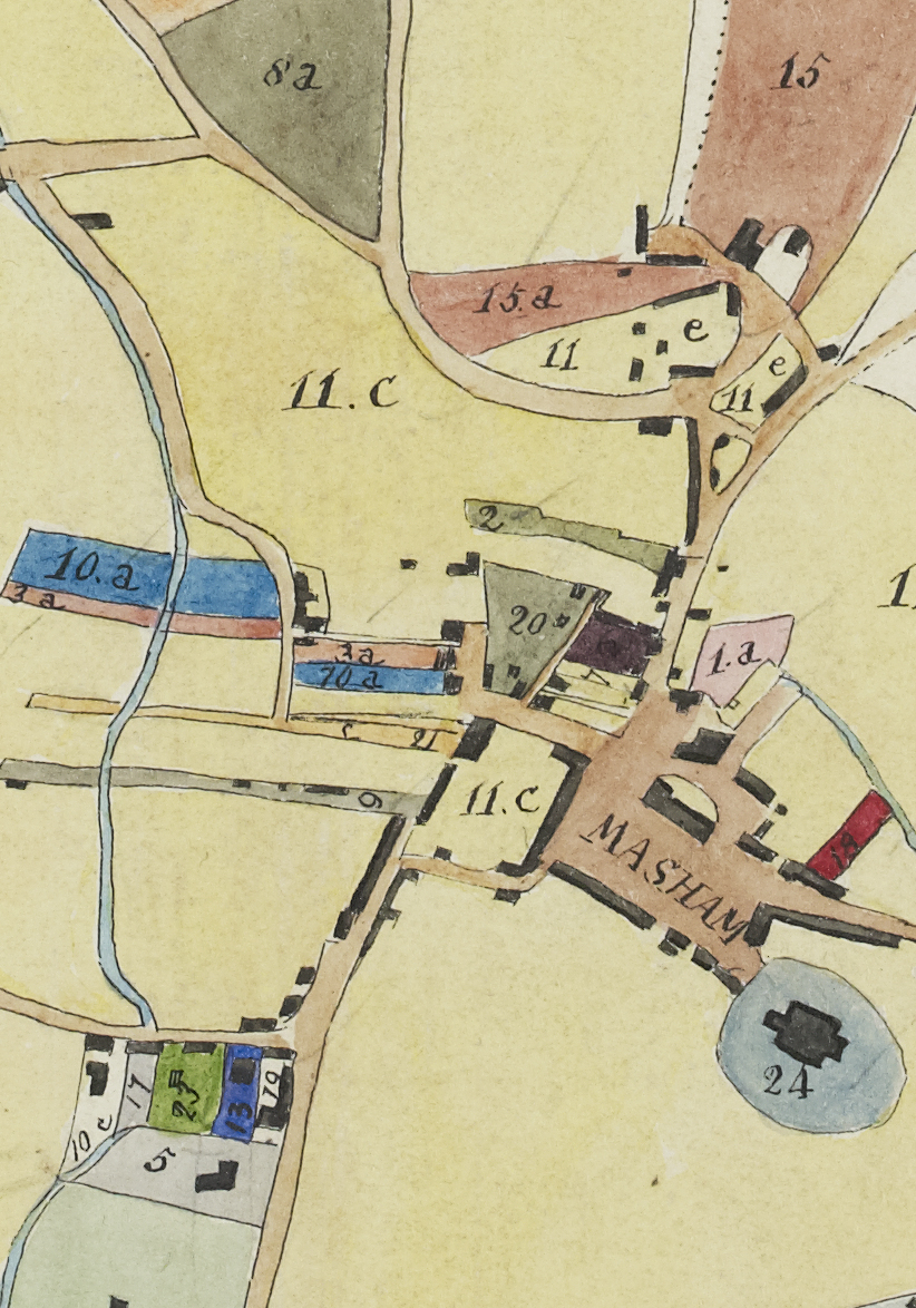
Masham tithe map, 1839 and detail showing Masham church and market place [T PR/MAS]
Enclosure of the open fields
Parish record collections may include material relating to enclosure, a process which usually involved the consolidation and redistribution of the dispersed strips of the open fields and the division of areas of common and waste into new fields, enclosed by hedges, fences or walls. What had been large areas of communally-farmed land in a parish were divided into smaller fields farmed by individuals, a practice which became widespread by the 18th and 19th centuries.
Enclosure Acts frequently removed the obligation to pay tithes. This was done either by the allotment of land in lieu of tithes, or by the substitution of a fixed money payment, details of which were recorded in the Enclosure Award and associated enclosure map. For this reason, 19th-century tithe maps do not exist for every parish, or cover only parts of a parish.
Details of enclosure maps and awards held at the Record Office can be found in our Guide no.4. See also The National Archives Research Guide on Enclosure Maps & Plans and our 2022 blog providing a case study of Enclosure and the Landscape: Harome, near Helmsley.


Enclosure maps of Kirk Hammerton, 1767 and 1861 [I PR/HMK]
Record Office map guides
You can find details of our holdings of maps and plans, listed alphabetically by place, in our searchroom Guides:
Guide no. 3: List of North Yorkshire & North Riding Maps & Plans
Guide no. 4: List of North Yorkshire & North Riding Enclosure Awards & associated documents
A selection of our historic maps are available to view and/or purchase via our online shop.
Further information
The National Archives Research Guide on Tithes
Fonge, CR. 1994 Tithe Awards and Maps at the Borthwick Institute: A Handlist. York: Borthwick Institute List and Index 11.
Kain, RJP. & Oliver, RR. 2011 The Tithe Maps of England and Wales: A Cartographic Analysis and County-by-County Catalogue. Cambridge: Cambridge University Press.
Kain, RJP. & Prince, HC. 2006 The Tithe Surveys of England and Wales. Cambridge: Cambridge University Press
